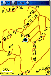
In last week’s Waypoints, I issued a challenge to Free Geography Tools’ Leszek Pawlowicz to check out Open Street Map (OSM) on a Garmin handheld, now that OSM has incorporated U.S. TIGER data. He good naturedly accepted the gauntlet and posted his findings. The screen shot at left shows a sample.
I’m disappointed that using OSM data in this way doesn’t allow for autorouting. Still, for those of you with Garmin handhelds that don’t want to lay out the bucks for MetroGuide or City Navigator, this is another option.
Thanks Leszek!

Rich, for what it’s worth I’m working on creating routable Garmin maps from OSM data, but my progress has been slow because my time is very limited. I actually already created one version using XSLT, but it chokes on even 10 MB input files, so it’s not usable.
Karl,
Keep me posted on how it goes. You can email me at rich at makeyourownmaps dot com.
I am wondering does any of your hand held have city street and address cap.
I bought a Garmin Dakota 10 which is useless for city use. no address cap. why?
Tom
You need to add maps like City Navigator to get that functionality.
Oh wait, did you put OSM maps in it? Try switching to the automotive profile.
I’m not sure I’m on the same page as you guys but my GPSmap62stc allows me to enter and Find house address’ from osmusa. To route to the address you have to have the unit in Automotive Profile but not to find the street address on the map you do not.