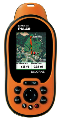
We heard about the DeLorme PN-40 earlier this summer, so today’s announcement of its pending release this fall comes as no surprise. One new piece of info though — they’ve scheduled a September shipping date.
Low cost aerial imagery and USGS quads
The other new piece of information is that you’ll be able to download all the aerial imagery, USGS topo quads and NOAA charts that you want for an annual fee of $29.95. I’ve been merciless in my criticism of DeLorme pricing; prior to this thirty bucks would have only bought you two 7.5′ quads worth of imagery. So here’s a big thank you to DeLorme for giving us this deal. I can’t imagine owning a DeLorme handheld and not ponying up the extra bucks for imagery.
DeLorme PN-40
In case you missed it, the forthcoming PN-40 is basically the PN-20 on steroids. In addition to the ability to view aerial imagery and USGS quads on screen, the PN-40 ups the ante with the following:
- A dual-core processor for fast map redraws
- Super high-sensitivity 32-channel Cartesio chipset by
STMicroelectronics delivers near-instantaneous signal acquisition and
ConstantLock™ satellite retention - 500 MB of onboard Flash memory
- 3-axis electronic compass with included accelerometer performs when held in any position—while in motion or standing still
- Sensitive barometric altimeter for reliably accurate altitude readings
- Supports SDHC high-capacity SD cards—32 GB or higher
- Fast USB 2.0 data transfer to internal memory or SD card in device
- More detailed onboard base map data for the U.S., now with
secondary and connector roads (along with major highways and
thoroughfares for the entire world)
The screen size of the PN-40 is only 2.2", but it makes up for size somewhat with its 220×176 pixel high-resolution display.
Related posts:


Wow, I’m a little surprised to see the pricing on the aerial images to swing so far in the other direction. It’s gone from absurd to dirt cheap. That should help them in their push for market share.
From the screen shot, it looks like they haven’t done anything about their data fields. Compare all the wasted whitespace to a Garmin…
You probably want to avoid the words “hard drive” there. This unit surely doesn’t have a hard drive in it and from their protocol spec, it doesn’t present itself to the host a a mass storage device.
I don’t understand why aerial imagery has to cost anything when you can receive it free over the Internet.
Robert,
Yikes! How did I manage to put that in there? Correct you are, as usual, and the misleading text has been removed. Thanks for catching that.
Jake,
Flippant answer – To make money
Alternative answer – The imagery has to be compatible with the device. They have development costs, storage costs, maintenance (updating imagery) costs, etc.
I think you mean 32 MB, not 32 GB, for SD cards. AFAIK, the largest currently available SD card is 8 GB.
Leszek,
That’s straight from DeLorme. Maybe it supports a standard for higher capacity SDHC cards than are currently available.