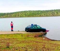
 Well, it finally happened. A GPS with bad map data led someone into a lake at night, resulting in a drowning death.
Apparently, the GPS receiver showed an old road as passable, despite the fact that Spain’s La Serena reservoir was built in 1989. Fortunately the passenger was able to make it to shore safely; the driver was not so lucky.
"It seems the GPS system pointed them on to an old road that ends in the reservoir, and that in the dark they were unable to brake in time, with the car taking just a couple of minutes to sink," the Red Cross said in a statement.
We don’t know the device manufacturer or the map provider, but this story got me thinking about some other items I’ve come across in the past few days, on the generally sorry state of maps in our devices. First, there was a post on the GPS Review forums, basically saying that map updates are useless. Then there was Mike Dobson blaming Tele Atlas’s failure to fully utilize crowd-sourced data on undercapitalization:
It is hard to imagine that a company would invest in technology as potentially useful as MapShare and then not have the time or money to analyze the data in order to produce a comprehensively updated navigable map databases.
TomTom’s market cap is now approximately €1 billion. You do remember that they agreed to buy Tele Atlas in 2007 for approximately €2.9 billion? So today you could buy both companies for approximately one-third of what TomTom planned to pay for TA in 2007.
I presume that TomTom’s “decline in fortunes” has negatively impacted Tele Atlas and its ability to finance a comprehensive update its database.
Are our expectations too high? After all, paper maps have errors too. Is map data just undervalued? No one, not NAVTEQ, Tele Atlas or Google, seems to be able to keep up with the constant changes, or even get decades-old changes right. Corrections seem to lag behind the companies’ stated time frames. Is this a role for government to take on? That probably won’t happen in a time of huge deficits and growing austerity measures. I have no answers, only questions. What’s your take?

Waze is the answer… community created maps with a fast update cycle bringing accurate maps to you for free.
Surely folks are still expected to look out the windshield while driving. I don’t think its realistic that they will ever be able to keep up with road changes. The only hope i see is that some sort of connection exists between map makers and local govt. (in the states) and that those govts use computerized GIS information. Any changes to roads/info in GIS would automatically feed to map makers. Local govt has a stake/interest in keeping this info up to date for tax/revenue purposes. This might shift the burden of map accuracy to local government. Also, purchase of a GPS should inlclude lifetime free map updates for the life of the unit.
Rick
Local governments often try to charge map makers for the data, frequently at unreasonable rates. The governents obviously have the GIS info themselves, but they regard it as a valuable resource which can be sold to anyone with sufficient funds.
This story seems really suspicious to me. They built a reservoir on top of a road but didn’t bother to remove the road or to blockade it in any way? How is the GPS at fault for that? Someone driving around at night lost could’ve just as easily made a wrong turn on to that road and into the reservoir. Leaving a road open that leads directly into a body of water borders on criminal negligence on the part of the local officials (assuming that the news story isn’t omitting details).