
Hands on with the Garmin eTrex 20
The Garmin eTrex 20 is the mid-range model of three new units that bring a long-awaited update to the popular eTrex series, which now offers paperless geocaching, new customization options and BirdsEye aerial imagery capability.
I’ll get into all the details in a moment, but first let’s look at what separates the eTrex 20 from the other models in the series…
Related units
- Step up to the eTrex 30 and you’ll add a triaxial electronic compass, barometric altimeter, wireless data sharing and Garmin chirp compatibility
- Going the other direction, drop down to the eTrex 10 and you’ll get a monochrome screen and lose the ability to add maps
- To see how the eTrex 20 stacks up against other models, check out my Garmin handheld GPS comparison chart
Garmin eTrex 20 hardware
Buttons
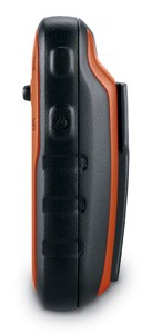
There are six buttons on the eTrex, three on the left, two on the right and one on the front (see image at top of page):
- Zoom in and zoom out buttons – These are on the left and can also be used to navigate menu lists a page at a time
- Menu button – (Also on the left side) Brings up a context sensitive menu; double-tap to access the main menu; press and hold to bring up the Find menu
- Back – On the right side; moves you back a step in the menu structure
- Power/Light – (Also on the right side) A short tap brings brings up a screen with date/time, battery and GPS status; additional short taps toggle between 0, 50 and 100% backlight; press and hold to power down
- Thumb stick – Located on the front of the device, you can toggle it side to side or up and down to navigate menus and pan the map; press down to enter a menu command or select a map point; press and hold to mark a waypoint
Display
The eTrex 20 has a bright but small display that is easily visible in sunlight or with the backlight engaged.
Hardware pics
The image below of the rear of the unit shows the mounting spine for a bike mount or carabiner clip (not included with the purchase of the eTrex 20, sad to say, although a lanyard is). Unlike the Oregon and 62 series, the spine is plastic, which could lead to some wear.

Here it is with a carabiner clip attached, which I found somewhat difficult to remove. Oddly enough, I had no trouble removing it from the standard Garmin bike mount.
Here’s the battery compartment, showing the microSD card slot and the mini-USB connector under the top rear flap…

With 1.7 GB of internal memory, many users will never need to make use of the memory expansion slot.
Garmin eTrex 20 interface
When you power up the eTrex 20, you’re taken to the Main Menu (below at left). You can change the order of items by pressing the menu button. If you select another screen (e.g., map) and then press the menu button, you’ll find a context-sensitive menu (shown below at right).

Garmin eTrex 20 features
 GLONASS

The one item found on the new eTrex series missing from all other Garmin units is the ability to use GLONASS as well as GPS satellites. There is an option to use GPS only, but no option for GLONASS only. Theoretically, GLONASS will improve accuracy. This may be especially true at northerly latitudes and in urban (and natural) canyons. I’ll talk about this a bit more in the performance section of this review.
More new features for the eTrex series
Many of the features found on higher-end Garmin handhelds are now available on the eTrex 20. These include…
Paperless geocaching
This gives you the ability to view description, hints, log, etc., in the field. The eTrex 20 also allows you to filter caches, letting you search by size, difficulty, terrain, etc. I’ll have more to say about geocaching in the performance section of this review. Some screenshots:

BirdsEye aerial imagery and topo maps
The eTrex 20 is fully compatible with Garmin’s BirdsEye products, including their aerial imagery and topo maps of the US and Canada. Each runs $30 for a one-year subscription; imagery you’ve downloaded during that period can still be used, even if you don’t renew. While the images below weren’t captured on an eTrex, they should give you an idea of the capabilities…

BirdsEye aerial imagery is particularly useful for urban cachers, outdoors lovers in the open landscapes of the American west, and for boaters. I find it less useful under the dense canopy of the eastern US.
I absolutely love the BirdsEye topo product. There is nothing quite like having the map on your device look exactly like the USGS topo in your hand.
Advanced track navigation

I have written before about advanced track navigation, but basically it will give you the best of both worlds when it comes to following a track or route. Simply choose a track to navigate and it will construct a route of waypoints along the track, add in high and low points, and give you the actual track mileage to each point, as shown at left.
Garmin custom maps
Now that we have BirdsEye Topo, there isn’t as much need for custom maps, but hey, you can put a PDF park map on your eTrex, and that’s pretty sweet.
Calendar
The Calendar displays dates when waypoints and tracks are saved, and it also displays geocaches that you’ve logged.
Profiles
Profiles allow you to save different groups of settings; you can have one for geocaching, one for mountain biking, one for road riding, etc. These are discussed more below under “Customizing the Garmin eTrex 20.”
More eTrex 20 features of note
Route, Track and Waypoint management
The eTrex 20 has excellent route, track and waypoint management tools, including:
- Waypoints – The ability to project a waypoint, average location, set proximity alerts, and to reposition a waypoint at your current location
- Tracks – You can choose to hide or show multiple tracks on the map, view an elevation plot, and give them a custom color (17 colors are available); the color of the active track may also be changed
- Routes – You can view a map of the entire route, edit the route, reverse it and view an elevation plot
Ability to add free maps
One of the great things about Garmin handhelds is the ability to add free maps to them, and the eTrex 20 is no exception. GPS File Depot is an excellent source of maps for the eTrex.
 A note about map management
I’m not sure whether this is a bug or not, but the eTrex handles maps differently than other recent Garmin models. When I loaded multiple maps, renaming them one at a time, they showed up in Map Setup as one combined mapset (shown at right).
UPDATE: It appears that this may not have been a Garmin issue. It is possible that a MyTrails update on October 30 fixed this issue. I can now upload individual mapsets, although I stil have a corrupted file that I can’t get rid of!
Customizing the Garmin eTrex 20
Main menu item order – You can customize the main menu item order by pressing the Menu button while viewing the Main Menu.
Accessing pages via the back button – Use Setup > Page sequence for this, but be aware that these pages will disappear from the main menu.
Profiles – The eTrex 20 comes with recreational, geocaching, automotive, marine and fitness profiles. You can switch profiles by selecting Profile Change from the Main Menu. Or create a new one by going to Main Menu > Setup > Profiles > Create Profile. Select the new profile to edit the name. Any changes you make in menus or other settings will be retained in that profile. So start changing things! Want track up when geocaching and north up when biking? No problem. How about a separate profile that just shows USGS topos or aerial imagery? The possibilities are nearly endless.
Data fields – You can change data fields on just about any screen that has these; usually you just press Menu > Change Data Fields.
Dashboards – Instead of data fields (and in some cases in addition to), you can select a dashboard for the map, compass and trip computer screens. Choices (depending upon page) may include automotive, stopwatch, small or large data field, recreational, compass, geocaching or elevation plot (the elevation dashboard is only available on the eTrex 30). I’ve included screenshots showing a couple below. For the trip computer and compass pages, you access this via Menu > Change Dashboard. For the map screen, choose Menu > Setup Map > Data Fields > Dashboard. The one downside here is the small screen on the eTrex series; using a dashboard can significantly reduce map real estate.

Garmin eTrex 20 tips
I imagine there are more, but here’s a few tips:
- Use the zoom buttons to jump a full page in a menu
- When entering a name, the zoom buttons will switch between keypads
- You can create a custom startup message (e.g., if found, please call…) by connecting it to your computer and editing the Garmin/startup.txt file
- You can check the battery level by briefly pressing the power button; you may also dedicate a data field to battery status.
Garmin eTrex 20 performance
Battery life
With the eTrex set to record a track point every five seconds, I left the device on, sitting stationary, under light canopy, powered by a fully charged set of Eneloop NiMH rechargeable AA batteries. With the backlight set to remain on full, batteries lasted 10 hours and 17 minutes. The backlight off test is still running, but I wanted to go ahead and post this. I’ll update that info later today. UPDATE: With the backlight off, the eTrex 20 ran for an amazing 23 hours and 29 minutes before shutting off.
Tracks
Tracklog accuracy was tested with the eTrex 20, GPSMAP 60CSx (with SiRFstar III chipset) and a GPSMAP 62s mounted on the handlebars of my mountain bike. All units were set to record track points every five seconds. Tracks were collected on out and back runs and then analyzed for track separation errors. The idea here is that, ideally, the track recorded on the way out should match perfectly with the one recorded on the way back to the trailhead. Of course no unit ever meets the ideal.
The 60CSx performed best, with less errors in general and a maximum track separation error of about 80’. The 62s had significantly more segments with easily visible track separation errors, maxing out at around 120’. The eTrex was worst, with more visible errors that tended to be separated by a greater distance, maxing out at around 125’. I find it interesting, but not surprising, that the oldest unit with the most mature firmware performed best, while the newest unit with the least mature firmware performed worst. Here’s an image of an eTrex 20 track (you should be able to click on it for a larger image)…

It gets more interesting when you look at the geocaching test results…
Geocaching
So how good is this GPS for geocaching? I set out to find out, but there is one caveat: I’ve yet to come up with a good way to test geocaching accuracy. There are just too many variables – accuracy of the cache coordinates, satellite constellation variability, terrain (multipath effects), etc.
So having said that, here’s a very unscientific test. After becoming familiar with the unit, towards the end of my testing, I made some cache runs. I set the units down on top of the cache one at a time and recorded the reported distance to cache in feet. The results are shown below.
| GPSMAP 62s | Oregon 450 | eTrex 20 with GPS+GLONASS | eTrex 20 with GPS only | |
| Cache 1 | 6 | 14 | 16 | 6+ |
| Cache 2 | 20 | 49 | 10+ | 15 |
| Cache 3 | 36 | 29 | 13 | 48 |
| Cache 4 | 30 | 37 | 26+ | 44 |
| Average | 23 | 32.25 | 16.25 | 28.25 |
Not bad, and you can see that GLONASS appears to result in some improvement. The plus signs indicate cycling, where the distance to cache would cycle from a low number to a higher number over a period of a minute or so and then repeat. In this situation, I used the lower number in the charts above. The eTrex 20 seems to suffer from the malady that affects all new Garmins, where the firmware is far from perfect. This cycling was also seen in early firmware versions of the GPSMAP 62 and Oregon series.
Lags and redraws
I noticed some slight lags when navigating menus, and a bit of a delay (a second or so) on map redraws when panning the map. I noticed no map redraw delays while mountain biking with the unit though. Some users have reported map redraw delays with raster imagery such as Garmin’s BirdsEye products, though I believe these reports have been limited to map panning and not delays on the moving map.
Garmin eTrex 20 pros
- Bright display
- Small size
- GLONASS for improved accuracy
- Paperless geocaching capability
- BirdsEye aerial imagery and US/Canada topo compatibility
- Advanced track navigation
- Garmin custom maps capability
- Customization options (dashboards, profiles, etc.)
- Excellent battery life
Garmin eTrex 20 cons
- Small display
Mapsets combined even though renamed from gmapsupp.img- Distance to destination cycling and tracklog separation
(and possibly the mapset issue)point to immature firmware - No electronic compass or barometric altimeter
- No wireless data transfer or chirp compatibility
Garmin eTrex 20 conclusion
Despite some early bugs, I like the eTrex 20, and think it will be a good first unit for all sorts of outdoors lovers. My quibbles with it are pretty minor, and Garmin has a good track record of fixing significant issues (although it can often take awhile). The track separation issues aren’t bad enough to cause most folks navigation problems, though the distance to destination cycling could prove frustrating to geocachers. The extensive feature set, including paperless geocaching, GLONASS support and BirdsEye aerial imagery capability, is very nice for a unit that runs under $200.
More Garmin eTrex 20 reviews
- Consumer-authored Garmin eTrex 20 reviews
have been posted at Amazon
- An eTrex 20 video review:
I’ll be posting more hands on GPS reviews as they appear, but in the meantime, here are some…
Other Garmin eTrex 20 resources
- The Garmin eTrex 20 owners manual
- To see how the eTrex 20 compares to other models, check out my Garmin handheld GPS comparison chart or use Garmin’s own comparison tool
- The official Garmin eTrex 20 web page
- A video comparison of the 62s and eTrex 20
- Our handheld GPS FAQs
- New to GPS? If so check out our handheld GPS 101 series; otherwise, here is handheld GPS 201
- How to install and display maps on the eTrex 20:
Compare prices on the Garmin eTrex 20 at these merchants:
- Check the current Garmin eTrex 20
price at Amazon
- Find the Garmin eTrex 20 GPS
at REI.com, where satisfaction is guaranteed and members get 10% back on eligible purchases
- Get the Garmin eTrex 20 from GPS City
- Buy the eTrex 20
direct from Garmin
Related posts:


In which orientation did you mount the etrex on your bike? Screen up? (i hope so 🙂 )
Yes, and at a slight angle. Worried about patch antenna orientation?
I was but… you did it right of course 😉
This may be an apples-and-oranges thing, but how does this unit compare with the DeLorme PN-30?
I upgraded from an eXplorist 400 to a PN-30 two years ago and just haven’t been satisfied. The PN-30’s UI is old-fashioned and the process of putting geocaches on the unit is inefficient. Cache Register’s required firmware upgrade will supposedly stop the unit from working with the Topo 7 software it shipped with, which I never used, but why would I intentionally cripple my unit? Since I am intimidated by Topo 7, I never got to take advantage of DeLorme’s aerials. The street routing of the PN was also clunky, though I do have a nuvi for that task.
The custom maps capability of the new Garmins appeals to me. The profiles also appeal to me, because I use a handheld for geocaching some days and bicycling on other days. I am hoping the eTrex 20 is easier to use and manage, and not left by the wayside like DeLorme did with PN-30 support.
I certainly prefer it. Dragging and dropping pocket queries is pretty simple.
Nice write-up! I didn’t appreciate just how small these units are until I saw your photo with the Carabiner clip as a point of reference. 🙂
Thanks. I should have done a photo comparing screen sizes, but it didn’t occur to me. These reviews are too long as is!
I haven’t been able to use the eTrex 30 I have much because of the terrible weather here in the North East. I did get to play with it some in a local park and set some waypoints and moved between them, use the”sight -and -go” feature. I tried the electronic compass and found I would rather use a real compass. The thing that I really like about this unit is it is so small, has a good set of features in it’s soft ware and still has the old eTrex feel to it. The things I don’t like are that it is made with some different materials that at first use seem to be sub standard. Plastic instead of rubber, plastic instead of metal. But then using other materials would add a significant amount of weight to the unit. Another thing is the attachment system, I too had a hard time removing the belt clip attachment and almost called Garmin to get it off. With an attachment on the unit, changing the batteries is impossible. So far so good, I would recommend buying one of these new eTrex units if you are new to the market or if you have been looking to update something you have been working with for a while.
Did you escalated tracklog accuracy problem to Garmin Tech Support?
I have just bought ETREX 30 and tracklog accuracy with or without glonas is simply terrible (firmware 2.3). I wrote to them, but no reply yet.
We have to push them to work on it!
No, and I haven’t seen any signs that it’s worse than other new introductions. It usually seems to take a few rounds of firmware updates to get it right.
Thanks,
It is all about pointing Garmin attention to this problem as a major one.
This is my problem with tracklog in comparison to 60CSx. This is only with GPS enabled on ETREX. With GLONAS it is even worse.
http://www.gpsvisualizer.com/display/1319717125-24589-198.152.70.2.html
http://www.garniak.pl/download/file.php?id=5450&t=1
yellow is 60CSx
I can tell you that they’ve read the review, as they are corresponding with me about the mapset issue.
Great!
another strange thing is the list of uploaded maps. I can see only one uploaded map and two pre-loaded maps, regardless of the number of maps uploaded.
Yes, several people are reporting this and Garmin is working to figure out what the issue is. Can you tell me what maps you’ve uploaded?
non-commercial maps compiled with cgpsmapper
so, if we have a chat here :-), I miss detailed information about tracks. There is no information what is the maximum saved track length, like for 60CSx, where it was 500. We know that the maximum is 100 tracks. How auto archiving works? If you reach 10k points, it should be archived and….active log is erased and you still have 10k points? Manual is very limited…..
Rich,
Thanks for the review. About the mapset issue, is this the one where you can’t turn off maps individually? Like if you have topo maps and CN maps, you can’t turn one off and have the other on?
That’s seriously annoying… would have to wait off on a fix before grabbing a unit.
I also had another question about barometric elevation. In the old units there’s no way to “disable” it… like if the weather is changing, elevation is all over the map… can you hint to them if we can disable barometric operations for awhile on demand? 😀
/sylikc
@ MaciekP Are they maps available from http://gpsfiledepot.com?
The max is actually 200 tracks. I’m not sure how archiving works on this one, but I assume it’s similar to other recent models like the 62 series…
http://garmin.blogs.com/softwareupdates/2010/03/getting-more-with-automatic-track-archiving.html
also: mapcenter.cgpsmapper.com and mapcenter 2 which is not working now. Also private custom maps created in MAPEDIT and compiled with free cgpsmapper compiler.
Does the Etrex output NMEA sentences through the computer connection? If so, how does it output GLONASS/GPS fix data?
In Setup > System, I don’t see an NMEA option. There are no Interface settings per se, only a USB Mode setting that offers Mass Storage and Garmin modes.
Interesting that you say a lanyard is included as from the forums this seems to vary. Mine didn’t come with one and Garmins spec doesn’t mention it:
https://buy.garmin.com/shop/shop.do?cID=145&pID=87771
Some seem to find one enclosed (like you did) and others don’t.
Apart from playing briefly with mine and loading maps from talkytoaster I’ve not yet been out on a trail with it, but will get out next week, really looking forward to it!
Strange. On my eTrex 20 box it says “Package contains: eTrex 20, lanyard, USB cable, manuals”
If you’re in the UK, it could be that the packaging and contents are different.
Very weird as ‘What’s in the box’ both on the US and UK site doesn’t mention a lanyard, and my box (from UK) doesn’t mention it. But it’s not just UK ones as one of the guys complaining about it was in the US.
@Kevin Yes, but hopefully they will have a fix soon.
Yes, a way to disable the barometric altimeter and have it rely on GPS elevation would be nice. There are other uses for it too (like flying in a pressurized airline cabin but stil getting valid elevation readings).
Amazon’s eTrex 20 page says it includes a lanyard too.
I think you guys might be confused on the mapset thing. I certainly was when Garmin switched things up in the 62. Rich, I thought you reported on this at some point, but I can’t find it now??? Maybe Garmin just mentioned something about it in a software update? Anyway, now you enable/disable entire .img files (as opposed to pieces of the maps across all maps loaded). I was skeptical, but after using it for awhile I kind of like it compared to my Oregon. It just makes sense when you’re dragging and dropping maps. Rich, from your screenshot, it looks like you’re loading multiple map types into a single .img. You can’t do that anymore if you want to turn off the individual parts.
Regardless, it’s worth noting that this is all much different than the old eTrex where only a single “gmapsupp.img” had to be rebuilt every time you wanted to tweak your maps. Highly annoying, especially when working with a serial connection 🙂
Kevin, this is all much easier than it sounds. I doubt very much your simple situation (Topo and City Nav) is a problem as long as you know how the system works. Rich can confirm of course.
Nope, I’m using this process…
http://gpstracklog.com/2011/05/loading-multiple-maps-to-garmin-devices.html
I finally found the link I was thinking about in the 62 software changelog. Garmin doesn’t exactly make it easy to find their info…bookmarked now 🙂
http://garmin.blogs.com/softwareupdates/2010/09/map-selection-improvements.html
It’s my understanding that Montana uses this new mapset handling method as well (still considering buying one). Apparently Garmin has switched behavior on us a little bit. As I said, once I got used to it I ended up liking it.
I dunno. I’m seeing five separate maps loaded to my Montana. See my comment below for more on this issue.
Rich,
I don’t understand why you list etrex 20’s ability to show different maps (or combine the maps) on one screen as a con, I view it as a huge plus. Old etrex maps or 60csx for that matter can only show one img file. Even if I had two maps files ( city navigator and topo), I was forced to display only one, if I want to switch, I have to rename the files with a computer. Etrex 20 totally changes that, now you can put multiple map sets on one microsd card, it automatically recognizes them and correctly shows them or combines them if some of them cover the same region. My etrex 20 correctly shows CN and New Mexico topo overlayed, and English version of China map. That is a wonderful feature.
It is an improvement over the old eTrex’s, but it doesn’t offer the flexibility we’ve come to expect in other recent Garmin handhelds.
The problem is if you have two of the same type maps for the same area. Say I have Garmin’s 24K topo loaded along with a free topo. A lot of folks do this because the free ones may have better trail coverage. If I can’t choose between them, am I going to see twice as many topo lines?
Are you seeing duplicate roads when you have CN and the NM topo overlayed? If not, which map is it showing?
Rich,
Thanks a lot for your clarification. I looked at it again, it shows the topo, city navigator map is hidden, but all of its search and routing functions are available.
Rich, have you tried installing a different mix of maps to see if the problem goes away? I wonder if you’re seeing is related to this problem which also exists on the Oregon – evidently MyTrails has a known issue. See: http://forums.gpsfiledepot.com/index.php/topic,2444.0.html
Yeah, I’m suspecting MyTrails as the culprit too. And they’re sticky. I delete them and they still show up. I’ve tried all sorts of variations and can’t get rid of the problem. Garmin provided instructions for a hard reset (hold down menu + enter + power/light while booting). It asks me if I want to erase all user data, I say yes, it asks for my language preference, but then all my settings, maps and problems are retained!
Rich,
I have another question. When I put different maps on the internal memory of the etrex 20 (1.7gb onboard memory), in the process of deleting and replacing some maps, I found that there is a sizable loss of available space. Now the property of the whole Garmin folder shows there are about 92mb files on it, but the system only has about 700mb available. What happens to the rest of the file space? How can I get that back? I was thinking of reformatting the drive after I backed up all of the 92mb files, which contain system files. I am worried that if anything go wrong, the gps won’t boot up. Any suggestions?
Thanks.
I don’t know. I’m showing 1.96 GB capacity on my eTrex 20 with 1.52 GB available. The Garmin folder is only 96.2 MB while the documents folder is 27.7 MB.
There should be 2 folders on your 20, one named Garmin and one named Documents as Rich indicates. If you’re only seeing the Garmin one then some files are being hidden from you … or you have a problem!
Which bicycle mount did you use with the eTrex 20?
https://buy.garmin.com/shop/shop.do?pID=11411
The trick with this zip tie mount is getting it tight. Take a screw driver and press against the base of the zip tie while pulling the tie tight with a pair of pliers works well for me.
Hi there
Great info. Im really impressed with this new Etrex series and am thinking of getting one soon for hiking and biking. I had a quick question if you wouldnt mind elaborating. The advanced track navigation lets you navigate a recorded track with added waypoints, giving you distance to next waypoint info. Very cool. Does this apply only to tracks that the unit has recorded in the past, or can i build a track + waypoints in google earth or topofusion, import that, and navigate the imported track? Will the waypoints be recognized and will i still get the distance to info?
Cheers for any info
I don’t think so. You can however download a .gpx file from Garmin Connect or one of the many .gpx repositories online and follow that. But it seems to break something if you edit the track or draw your own. Still, I haven’t done exhaustive tests of this and I could be wrong.
Hmm, thats too bad. Was hoping I could use tracks and waypoint info ive already built in GE. Not a major limitation for my intended use- it can still upload and follow a track from GE/TP, just not give the distance info, right?
Thanks
I think that what you’ll get is a highlighted track with distance to the end of it.
It looks like a My Trails update this weekend (see Oct. 30 release notes: http://gpsfiledepot.com/maps/view/53) may have solved the mapset issue. At this point it appears that it was not a Garmin problem as, after installing the update, I can load multiple maps to my eTrex 20. I still have a corrupted mapset file though, that I haven’t been able to get rid of, and I’m looking for a factory reset that works (apparently menu + enter + power/light does not).
Rich ,
I owed a 20 and was very unhappy , the unit seemed to be so slow and unresponsive at times , could not track to a way point effectively . Had to send the unit back was not comfortable , have u seem this in this unit ?
No, I haven’t. But I have heard a few people complaining about slow units. Maybe there’s a bad batch out there?
Rich,
Can you confirm something for me? You implied (I think!) in your review that you could have separate profiles using different mapsets. I’ve found that this doesn’t work on mine, any change I make is universal across the profiles. I was hoping to have only my road maps showing on the auto profile and my topo on my walking/geocaching profiles but it doesn’t work. They are show separately but if I disable a mapset in one profile then it’s disabled in them all.
I’m running 2.20 at the mo as 2.30 seems to have some problems with cache files!
Jon
They seem to stick in mine. I just enabled a map in one profile, disabled it in another, switched back and forth and the changes were still there. But I’ve got 2.30.
Thanks, I’ll have another go at mine. Would be logical for it to work as you describe.
Nope …
Maybe it got broke in 2.20 and fixed in 2.30 🙁
Weird. Now upgraded to 2.40 which seems to work fine with everything, except I still can’t get different profiles to display different map sets. If I disable a mapset in one profile then it’s disabled in all of them. Is anyone else (apart from Rich!) able to manage it?
Hi
A little curious as to how much of the map real estate is taken up by the elevation plot dashboard? Id like to have the elevation plot show up as a full screen right after the map page using the page sequence function, but cant find it. I saw it in the page list for the sequence menu on the 30, but not the 20. Is it possible to do that on the 20?
Thanks
On second look, it doesnt seem as though you can display the elevation plot on the map screen in the 20. Cant believe they left that off the 20 but kept it on the 30. Seems like such an obvious thing to have. Hopefully this can be fixed with a software update.
Yeah, looks like it’s only available on the unit with the barometric altimeter. I’ve corrected it above. You can view an elevation plot for a track on the eTrex 20 (and the active route too, I believe).
Yes, that’s right … on the 20 you can see the elevation plot of any route, including the active one.
Right, but they font make it easy to find with only a few button pushes. Id want to be able to make the elevation profile screen part of the ‘page sequence’ so that i can place it right after the map and have one button access to it. I might go submit a feature request at Garmin.
Any idea why map updates don’t overwrite those already installed on the eTrex 20? Updated maps are loaded as additional items and take up a lot of memory space. I deleted the older versions after downloading recent updates to City Explorers (London, Rome and Italy & Greece) and recovered an awful lot of memory – even though I have an 8G micro SD card to play with.
At the moment I am using my eTrex 20 to trundle around Naples and it works very well, back tracking is quite precise and the only problem I sometimes experience is due to the ‘artificial canyons’ between apartments buildings and the hellish Naples traffic at certain cross roads which cause the satellite signals to go haywire. The latter effect can clearly be seen on the trackplots as a series of zig-zags before things settle down again.
Sounds like something they need to fix (the map update issue).
Rich,
Update on the profile problem I raised. Just discovered it works fine if the maps are the ‘normal’ .img files, but I was trying to disable a BirdsEye Select file which is a .jnx file. For some reason disabling or enabling those files, even though they appear in the same list as the .img files, results in the change being applied to EVERY profile, hopefully something Garmin may fix in a future update.
Good to know. Thanks for tracking down the issue and sharing it with folks here.
For those geocachers out there who use Garmin’s Basecamp program with their new Etrex, there appears to be a bug in that caches marked as found in your Etrex still show with closed chest icons in Basecamp, not very helpful when trying to sift through caches on your PC.
Not helpful at all! Thanks for letting us know.
Rich,
Would you happen to know (or be able to find out) what chipset is inside this new Etrex? There doesn’t seem to be any definitive information anywhere else about this…
Just a curiosity factor… 😀
Garmin doesn’t release this info and as far as I know, no one has posted any details yet.
Hi, I guess that eTrex contains this Teseo II chip (because of GLONASS):
http://www.st.com/internet/automotive/class/1547.jsp
Is that the only chip available with GLONASS support?
No, but since STMicroelectronics is the “prominent” chip supplier for Garmin, it’s the most probable possibility.
But to be sure, somebody will have to dismout his eTrex. 🙂
I got the etrex 20 a week ago or so, and I might really like it, but I am having trouble learning how to use it. Garmin’s sites don’t have anything I have seen that does what I am afraid are simple instructions, like how to track a hike you are on, turn off the tracking at the end of a hike, and, what really frustrates me, put the “total ascent” field back to zero. Or transfer your hike from the gps to the computer.
Do you know of any sites where I can get explanations for the simple basic things one does with a gps? I own an edge 300 for biking, and it is so simple to use by comparison.
I’m about to return mine and stick with an updated edge 800 – which loads base camp and I will try for geocaching. Or just forget the whole thing. Any thoughts?
John
Have you tried downloading the full manual from Garmin? With that and the intuitive menu I find it relatively easy to find my way around. If you use Basecamp that also works with the Etrex 20.
I also use my Etrex for Geocaching, and using the Geocache profile the 20 works far better than my older Legend H.
You could also try posting any problems you have on sites like this:
http://forums.groundspeak.com/GC/index.php?showforum=11
Persevere. I’ve got a new Etrex 20 and find it great both for hiking and geocaching. Try downloading the full manual from Garmin’s website if you haven’t already done so. Incidentally your Etrex 20 will also work with Basecamp.
thanks, it appears from posting on the groundspeak site that i won’t be able to zero out my total ascent, but at least i know i’m not alone in my frustration. etrex 20: the best of times, the worst of times.
John
That field can’t be reset on the eTrex 20. I’m pretty sure it can be on the eTrex 30, which has a barometric altimeter. Elevation accuracy will likely be poor on the eTrex 20, so I’m not sure how much use it will be anyway.
You can use Garmin BaseCamp to transfer your track to your computer.
Here’s our handheld GPS 101 series… http://gpstracklog.com/category/handheld-sport-gps/handheld-gps-101
The Edge 800 isn’t really designed for geocaching or hiking. Handheld GPS have a learning curve, but I’d give it a bit more time.
I called Garmin and they said total ascent and descent could not be reset on the 30 either. the accuracy is better, so, I figure it won’t jump around and keep climbing from the stand-still position. However, only a total reset, at best, will zero out the category.
Unfortunately, the instructions I received about hard resetting did not work. How are you supposed to do that? does anyone know?
Also, in discussing this with REI, the person there suggested a 62s gps. Does anyone know if that has a trip reset for ascent and descent?
Thanks,
John
That is so weird. Sounds like something they should fix in a firmware update.
Their hard reset instructions didn’t work for me either.
I just verified that you can reset the total ascent field on the 62s.
Hope that helps.
The more time i spend playing with the unit in the local stores, the more little niggles I find with it that keep me from pulling out my card and buying one. The inability to reset the ascent box is another one added to the list. Im hoping Garmin will address some/most of these issues in a software update sooner rather than later.
I’ve had my eTrex 20 for about 3 weeks now (software is 2.40). I’m very pleased with it and have only one small niggle so far, it sometimes refuses to completely delete all track logs and I’ve had to do a factory reset a couple of times.
At the moment I am using my eTrex for wandering around Naples and its outskirts. Sensitivity is excellent – even indoors – and the latter gives some interesting confirmation of how urban traffic affects GPS reception. Our apartment block is situated close to a very busy cross roads and even though I sit perfectly still near a window, with GPS+GLONOSS on, it invariably starts plotting a ‘track’ as the satellite signals are bounced about by moving vehicles down on the road so that I appear to be moving around by as much as 70 metres and in random directions. This ‘plotting’ continues for as long as I leave the unit switched on in the room. During the night when traffic dies down so does the plotting and my location remains more or less stationary. Road traffic also afflicts back tracking accuracy to a lesser extent when retracing paths out on the streets. However, when I do back-tracking tests walking along a 1 km long pier which sticks out into the sea in the Gulf of Pozzuoli far away from the roads, back-tracking is near perfect and the out and home plot lines cannot be distinguished from each other on my computer screen.
Interesting. Track/location errors of this sort are generally due to multipath reception issues, signals bouncing off buildings, etc. I wonder if moving cars could be generating more multipath effects.
I had an initial problem with tracks. I set mine to not record tracks, but kept wondering why I kept getting tracks shown in Basecamp, then realised that I’d been switching profiles to learn more about the Etrex and if you don’t want tracks to record you need to switch them off in every profile. So if you don’t want to record tracks switch them off in every profile you use!
Good tip, though I doubt many handheld users are turning off tracks.
I’ve had this reply from Garmin, in response to a query sent regarding the problem I had with BirdsEye topo maps (those with .jnx extension) not being able to be disabled/enabled in different profiles (disabling/enabling in one profile disables/enables them in all profiles).
Dear Jon Henderson,
Thank you for contacting Garmin Europe.
I am happy to help with your query. I have replicated this issue in the
office, and as such passed it on to the software developers. This will
hopefully be resolved in a future update. Many thanks.
Please help us improve the service we offer you by taking our Customer
Support survey. Please click the following link –
http://www.surveymonkey.com/s/OutdoorFitness
If there is anything else I can help you with then please let me know.
Alternatively you can search for a solution on our forum: https://forums.garmin.com
or our online knowledge database here: http://www.garmin.co.uk/support
Kind regards,
Matthew Morley
Garmin Europe
Good news!
Rich,
I went to test one of Etrex 30 units at REI the other day… and in the map enable/disable screen, I saw something of the sort:
I selected map setup, then went to see the list of maps. Selected the basemap, and saw “Enable” and “Disable”
Then there was a “Digital Globe” entry, and under that I see
“Enable – Brighter”
“Enable – Bright”
“Enable – Normal”
“Disable”
What’s that all about? Is that a special type of map overlay? I only own a Vista Cx and haven’t played with any of the newer units… and I don’t remember seeing this option on the Oregon 450 when I tested it.
These are settings that were added sometime back for BirdsEye imagery. It should be on all BirdsEye capable units now.
I’m cuious on what you mean by this:
UPDATE: It appears that this may not have been a Garmin issue. It is possible that a MyTrails update on October 30 fixed this issue. I can now upload individual mapsets, although I stil have a corrupted file that I can’t get rid of!
The issue I fixed with the Oct 30 update was on units like the OR, My Tails would show 3 times. It was an issue with the codepage I was using. I’m not sue what you are saying was the issue.
Also instead of using a geocache to compare accuracy (the cords for the cache can be bad), select a spot in your backyard and use waypoint averaging. Go back and use update over a couple of weeks to improve the accuracy. Then you will have a point you know with great certianty the location of. Then you can compare how far the various GPSs show fom the point.
Jim,
I’m not sure I worded it very clearly. I can remove every supplemental map from the device, but when I install another map (not MyTrails), I get a mapset that looks like this…
http://gpstracklog.com/images/eTrex%2020%20mapset%20issue.jpg
If its showing My Trails installed when its not, my bet would be something is corrupt in the profile.
Thanks Jim. Good idea; I’ll check it out.
Garmin eTrex 20 is currently on sales at EMS for $152.
Thanks for the tip. Here’s the link…
Garmin eTrex 20 at EMS.com
I have a quick question:
I was thinking about getting this for my Dad for Christmas. He is an avid skier and always talks about how many runs he took at the end of the day. Could he track total elevation descent with one of these devices? I know it wouldn’t be accurate without the barometric altimeter but it doesn’t need to be perfect, just a number that would be close. Would this device do that?
Thanks!
GPS accuracy is much less accurate in terms of elevation than it is for lat/long. For distance it would be great, but for elevation accuracy (and it would be far from close many days, since the satellite constellation varies from day to day), I’d go for something with a barometric altimeter. The Foretrex 401 is an option to consider if maps aren’t needed…
http://gpstracklog.com/2010/02/garmin-foretrex-401-review.html
Does he have a smartphone? He could try an app first.
Unfortunately he is not a very technological guy – he doesn’t even have a cell phone nevermind a smartphone!
I just decided that he could use it sailing and hiking too (in which case altitude doesn’t matter as much), so maybe something without maps isn’t the best. I would like to ask how much worse the altitude reading would be between an etrex 20 and an etrex 30. I guess I am trying to decide whether the extra cost is really worth the extra function. If it is different by less than 100 feet then that’s okay. If you think it would be about 500+ feet or more off then I would definitely need to rethink.
I’d have to check. I’ve seen 1000′ errors on total elevation gain. It depends on the visibility of the satellite constellation on a given day too.
If it is easy for you to check I would really appreciate it. Wow with 1000 foot errors you wouldn’t even know he was on a ski hill!
My eTrex 20 just arrived today and I’ve played around for a few hours. It seems the custom map with images larger than 1024×1024 will not be found at all. The machine just refused to see this custom map even if the file is put in the right folder. This is a different from Oregon which will display the customer in lower resolution. Also the drawing speed for custom map is really slow in those zoom levels which are really visible to you. eTrex 20 is not really friendly to custom maps. As for the combination of GPS and Glonass, it reports my position is at the altitude of -17 feet in the open which is wiered as it should be above the sea level. Will do more tests later.
The custom maps issue doesn’t surprise me that much; the processor probably isn’t quite as beefy as in the Oregon series.
Since the eTrex 20 doesn’t have a barometric altimeter, it relies on GPS for elevation, which is much less accurate than it is for lat/long.
After some more observations, it seems the elevation measurement from GPS+Glonass is actually at least 30 or 40 feet less than the actual altitude. GPS in this case reports pretty much the correct altitude. Tests are done with either WASS on or off. I wonder whether this is because Glonass has even worse elevation measurement than GPS?
Have you seen Garmin’s FAQ on this (not specific to the eTrex however)
_____________________________
https://support.garmin.com/support/searchSupport/case.faces?caseId=%7B66f1b0a0-4cd6-11dc-4733-000000000000%7D
Support
Frequently Asked Questions
How accurate is the GPS elevation reading?
02/02/2011
GPS heights are based on an ellipsoid (a mathematical representation of the earth’s shape), while USGS map elevations are based on a vertical datum tied to the geoid (or what is commonly called mean sea level). Basically, they are two different systems, although they have a relationship that has been modeled.
The main source of error has to do with the arrangement of the satellite configurations during fix determinations. The earth blocks out satellites needed to get a good quality vertical measurement. Once the vertical datum is taken into account, the accuracy permitted by geometry considerations remains less than that of horizontal positions. It is not uncommon for satellite heights to be off from map elevations by +/- 400 ft. Use these values with caution when navigating.
I’ve known the fact that GPS is not good at the elevation measurement for years. However, based on years of user experience, I find GPS actually does a good job at it in most cases if it is measured in the ok terrain. Often the difference from the actual elevation is within 10 feet. The reason why I bought eTrex 20 is to see how GPS+GloNass performs in the accuracy compared to GPS alone. For horizontal position, they don’t really make difference in open space. However, the vertical position is where makes the difference. GPS has the right measurement but GPS+GloNass is off by tens of feet. I should do more tests in more tough terrain in the coming weekend.
My experience sure has been different. Here in coastal New Jersey the terrain is very flat with good views of the sky in most places. It’s very common for my GPS’es (60csx, Oregon, Montana, Nuvi) to give very erroneous readings, like 80 feet below sea level when the true elevation is 70 feet abe sea level. These errors might not be so noticeable if you were on a 3000 foot high mountain, but they really stand out in a flat coastal area.
Please let us know how your testing works out. It will be very interesting if GLONASS is causing added vertical error.
I did some tests today but the result is inconclusive. Here is the result (GPS accuracy is included within parentheses):
Actual Height / GPS+WASS / GPS+GLONASS+WASS / GPS / GPS+GLONASS
21 / 0 (7) / 47 (8) / 12 (9) / 34 (9)
383 / 382 (7) / 381 (8) / 398 (9) / 382 (9)
383 / 393 (7) / 371 (12) / 382 (9) / 371 (9)
2,517 / 2,517 (9) / 2,518 (13) / 2,516 (9) / 2,526 (10)
Huh, so you’re saying the most is was off by in all of your tests was only 12 or 13 feet? That’s pretty impressive!
Brendan,
gpshiker is looking at elevation accuracy, not horizontal positioning. Though I’m not sure I’m seeing any recurring effect from GLONASS in the numbers.
I did another test on a NGS benchmark today.
Benchmark: Mission Peak WM9B5
10S E 598906 N 4152320, 2,500 ft. elev.
http://www.waymarking.com/waymarks/WM9B5_Mission_Peak
Garmin eTrex 20 (FW: 2.50 / GPS: 2.32)
Measurement Result:
GPS + GLONASS (WASS on)
10S E 598907 N 4152322, 2,513 ft. elev.
GPS (WASS on)
10S E 598906 N 4152320, 2,499 ft. elev.
GPS (WASS off)
10S E 598906 N 4152320, 2,500 ft. elev.
GPS + GLONASS (WASS off)
10S E 598905 N 4152321, 2,485 ft. elev.
The GPS (WASS on or off) mode is exactly the same as the actual coordinate of the mark. To the comparison, the GPS+GLONASS (WASS on or off) mode is a few meters off both in the horizontal and vertical positions. I’m surprised to see the result.
On the second thought, the data for the survey mark might not be reliable. I will try to find a mark listed on the NGS site to do another measurement.
Got a great deal on this unit for $151.99 at EMS..thanks to you people for posting this…will report back later…The deal was only one day…and had free shipping!!!..oh also picked up the Topo 24k for $79.00!!
@gpshiker – Keep us posted. Interesting stuff.
Finally found a reliable source. NGS benchmark HT2440
NAD83 UTM: 10S 0582281 4158025 Elev.: 32.29 ft.
Result:
1. GPS + GLONASS, WASS on
10S 0582281 4158024 Elev.: 24 ft.
2. GPS, WASS on (but didn’t get lock on WASS)
10S 0582282 4158028 Elev.: 30 ft.
3. GPS , WASS off
10S 0582280 4158027 Elev.: 33 ft.
4. GPS + GLONASS, WASS off
10S 0582282 4158028 Elev.: 35 ft.
Now I can see (GPS+GLONASS, WASS on) does have the best accuracy on the horizontal position. In fact, all combinations have good accuracies. GPS seems to have better measurement on the vertical position.
Will perform more tests when have time.
Yes, more tests would be good to verify this. Sounds like Garmin needs to work on their algorithm for calculating non-barometric elevation data on the eTrex series. Thanks for sharing!
After several tests, I come to the conclusion that GPS+GLONASS, under the open terrain, can not improve the best accuracy already achieved by GPS+WASS. It matches at best. However, GPS+GLONASS shines, due to the number of sats it receives, under difficult terrain that usually improves the accuracy GPS barely keeps. Now the question is whether GPS+GLONASS consumes more power than GPS alone? If GPS+GLONASS does consume more power, it should only be turned on manually while under the difficult terrain.
It should also be better the further north you are. BTW, I heard from someone else that with the eTrex 30, GPS+GLONASS increases accuracy of total ascent.
Did battery test on eTrex 20. put eTrex 20 by the window, backlight off. track log on.
1. GPS + GLONASS (WASS off): it lasts 23:37 and drifts 0.5 miles.
2. GPS (WASS on): it lasts 27:34 and drifts 0.82 miles.
eTrex 20 rocks.
I use Sony CycleEnergy AA rechargeable (2000 mAh) batteries.
Are you aware of any screen protectors for this new eTrex series? I always bought screen protectors in the past, but I decided to go without this time. I got a little 1/16″ scratch on my eTrex 20 already. Invisible Shield doesn’t have one. Not sure where else to look for a quality product.
This brand seems to be well rated:
Lexerd – Garmin eTrex 10 20 30 TrueVue Anti-Glare GPS Screen Protector (Dual Pack Bundle)
FWIW, I’ve put screen protectors on after getting a scratch before and was pleased that I couldn’t really see the scratch afterwards.
My eTrex 20 arrived with the screen already slightly scratched even though it was ‘protected’ with a little plastic sheet.
I bought the little cover/case thingy which is available on the Garmin website under Accessories for the eTrex 20.
It arrived two days after on line purchase and saves me a lot of worry.
My ‘toy’ is working fine but it, too, sometimes shows me below sea level when I’m wandering around Naples – same thing happened in London, too, but I know when I’m still on dry land, so I accept its having me on.
Yeah, GPS elevation readings are much less accurate than lat/long. That’s why units with barometric altimeters are so popular.
I would like a portable handheld Garmin that will allow me to navigate using a custom Google Earth Map. Is that possible and what is the minimum unit that will have that capability?
The eTrex 20 may be the lowest price unit with this capability, but you’ll need to make a Garmin custom map to do it, which is a pain, and there are significant limiations…
http://www.garmin.com/us/products/onthetrail/custommaps
Many people find this to be a better option, though the imagery sometimes isn’t as good or as recent…
http://gpstracklog.com/2011/07/garmin-birdseye-satellite-imagery-2.html
I just received my first handheld GPS device (a Garmin eTrex 20) for Christmas and am new to the world of GPS, but excited about jumping in and learning. Am trying to decide what the best maps are for a beginner like me… in particular the Garmin Topos vs. Bird’s Eye… I’m in California, a Mac-user, and will initially be using it predominantly for hiking/camping. Also any thoughts on format (DVD vs. download) or any other tips/suggestions for a beginner would be greatly appreciated. Thanks so much.
I’d look at the free maps at http://gpsfiledepot.com/maps/state/ca first. Here’s a tutorial on how to load them…
http://gpsfiledepot.com/tutorials/how-to-load-maps-on-my-garmin-gps-unit/#mac
I will say that the California topo seems to give people more problems than other maps though, sometimes generating a message that the map is locked. I’d give it a try though.
Otherwise, if you buy, I’d go with the Garmin 24K maps, and I’d get the DVD, which wil make it easy to use the maps on another unit if you decide in a few years to upgrade. I also prefer to transfer maps to a microSD card, so that if anything gets corrupted in the process, its easier to fix by just pulling the card and erasing the files off it.
Since your new to this, check out this series:
http://gpstracklog.com/category/handheld-sport-gps/handheld-gps-101
Thanks so much, Rich. Very much appreciated. And that 101 series looks like just the thing to help me get my feet wet. This really is a great resource you’re providing here. Thanks again.
Does anyone have the FCC ID number for the etrex 20? Inside the battery compartment, mine (purchased in Canada) says CAN310 where I think the FCC ID would be. Thanks.
— Richard Langley
FWIW, mine, bought in the US, says the same thing.
Has anyone tried using the Communicator Plugin with Google Maps to send a location to the Garmin etrex 20? Doing so, the plugin reports the location is successfully sent but where does it show up in the etrex 20? I couldn’t find a couple I sent. Thanks.
It should be in your Waypoints.
They did not appear there. I used a MacBook Pro with Safari Web browser. I’ll try different browsers and using Windows to see if that makes a difference.
I just tried it on my MacBook Air and Chrome and got the message “your browser is not supported to use the Garmin Communicator Plug-In,” even though the Communicator plugin page says it is supported for Macs.
WHAT A ACCURACY OF ETERAX GPS
That is covered in the performance section near the end of the review.
Thanks for an awesome review! I have this unit and can say that it has it’s challenges. In order not to sound overly negative, it is a great unit overall. The issues I have had are scary and annoying.
I travel a lot and so I like to put a lot of geocaches in place on the device. This causes all kinds of issues. I guess I keep exceeding the max on the device because it freezes on startup often. I’ve had it warn I have exceeded the max number of geocaches and then it promptly doesn’t allow access to any of them.
I cleaned everything off of it and got freezing on startup again. Thinking of returning my unit because that seems unacceptable.
It seems that Garmin could have done better testing with this model in conjunction with BaseCamp software. Basecamp is not user friendly (not even close) and works slowly.
Have you removed all .gpx fies on the unit? Here’s a discussion on file size limits that may prove useful…
http://forums.groundspeak.com/GC/index.php?showtopic=288426
Also, do you have the latest version of BaseCamp? They do seem to be making some speed improvements.
Any idea anyone why the Trip Computer ALWAYS shows a greater distance walked than the Track Manager? (when the track properties are displayed on the computer screen of course). The Trip Computer on my eTrex 20 invariably tells me I’ve walked between 600 – 1000 metres more than the Track Manager. The max distance I’ve walked so far at one go (I’m an oldie) has been 16 kms, but the error is more or less always of the same order.
(my software is now 2.60, but the descrepancy has been there right from the start)
Cheers
Try setting the tracklog interval to one point/second. The track distance will always be affected by this setting.
In the Tracks section setup of my eTrex 20 the Record Method – Record Interval menu shows only the following options: Most often, More often, Normal, Less often and Least often, that is in addition to AUTO. I’ve fiddled around for ages but there is no sign of being able to choose either Distance or Time. If I mess about too much it asks me if I want to ‘restore defaults’.
Just as a matter of interest, my eTrex manages to lock on to satellites even when I’m travelling around on the ‘open air’ sections of the Naples Metro – no go on airplanes, though.
Under Record Method, you don’t see Distance, Time and Auto?
This is weird …! When I read you reply, Rich, I switched on my etrex and under record method the display was exactly the same as yesterday, Most often, More often, etc., then, suddenly, without my touching any key whatsoever, it changed to show the Record method Distance and Recording Interval menu. … seems like I’ve got gremlins or something in my eTrex. I’ve switched it on and off a couple of times and it now shows distance, time and auto, etc., every time… Wonder if I should see a ‘shrink’ …’ Thanks very much for your help. Cheers
Strange things happen!
@gpshiker, I’m curious as to how you are measuring drift.
Rich,
My way to measure the drifting is to put the device at the stationary positon (by the window), reset the trip and monitor the trip mileage on the trip computer.
gpshiker
I see the same ‘drift’ (multipath reflections) when I leave my etrex switched on near a window. The trip computer shows movement when there isn’t any, especially if there is heavy road traffic nearby. Try it…
Waddy
Thanks!
I have a Sony Tablet S with GPS and it shows the same tendency to drift when sitting side by side with my eTrex near a window at home. When road traffic is scarce the position arrows move just a little, but high-sided vehicles such as buses cause both to ‘jump’ quite wildly.
Both the above GPS receivers also wander very slightly around the ‘still’ position when I’m about 1 km ‘out at sea’ in the Gulf of Pozzuoli on the pier at Bagnoli (Naples).
I got the eTrex20 about a week ago and been playing around with it for a while. I use it for trekking in remote areas here in South America, so I need topographic maps in it (I´m using Trackmaker for planning, which is an open-source software similar to Garmin´s Tracksource), but I´m having trouble converting these jpeg/pdf map files to the .img format in order to load them into the device along with the tracklogs. Any tips/site/tutorials I can check for more info on it?
Another approach is to use Garmin custom maps…
http://gpstracklog.com/tag/garmin-custom-maps
You can use free garmin map img for open street map. For Topo, choose the open cycle layer.
http://wiki.openstreetmap.org/wiki/OSM_Map_On_Garmin/Download
The detail of the map in your area depends on the degree of involvement from people in that area.
I received the eTrex 20 as a birthday gift and am learning the various features. Thus far I primarily use ‘Trip Computer’ and ‘Track Manager’ to record each mountain bike run and to give me my stats. However, I’m noticing a difference in mileage between the two. Just last the Trip showed 7.86 miles, but the track displays 7.6. I know it isn’t a huge difference, but it adds up over time. On Sunday I the trip showed 25 miles but the track only showed 24.4. I guess it’s more of a question of why would these two displays show different mileage? I rest both just before I pedal away from my car.
Thanks,
Dan
The track distance depends on the track recording settings. I believe that setting it to record every second will result in the most accurate numbers.
Ah, that makes a lot of sense, especially on curvy singletrack. The track log would lose some of my distance if it weren’t recording the various switch-backs. I just changed my gps to record every second and am looking forward to comparing the two results tonight when I ride. Thanks for the suggestion, Rich.
On my 12 mile ride Thursday night the results were almost identical between the two. However, on Sunday I rode 30 miles and the ‘Track Manager’ only showed 18. I’m guessing this is because the unit can only record 10,000 track points and then starts overwriting the earlier points? For these longer rides I’ll just need to remember to change the unit to record every 2 seconds.
And two seconds is probably enough unless you’re bombing downhills!
I was thinking of using Etex 20 on my bike. Can I create a route & download from my mac, using lat/long points & then can I have the gps follow this route?
Yes. Here’s a little more info on routes…
http://gpstracklog.com/2010/02/handheld-gps-101-routes.html