
Hands on with the Garmin eTrex 20
The Garmin eTrex 20 is the mid-range model of three new units that bring a long-awaited update to the popular eTrex series, which now offers paperless geocaching, new customization options and BirdsEye aerial imagery capability.
I’ll get into all the details in a moment, but first let’s look at what separates the eTrex 20 from the other models in the series…
Related units
- Step up to the eTrex 30 and you’ll add a triaxial electronic compass, barometric altimeter, wireless data sharing and Garmin chirp compatibility
- Going the other direction, drop down to the eTrex 10 and you’ll get a monochrome screen and lose the ability to add maps
- To see how the eTrex 20 stacks up against other models, check out my Garmin handheld GPS comparison chart
Garmin eTrex 20 hardware
Buttons
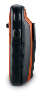
There are six buttons on the eTrex, three on the left, two on the right and one on the front (see image at top of page):
- Zoom in and zoom out buttons – These are on the left and can also be used to navigate menu lists a page at a time
- Menu button – (Also on the left side) Brings up a context sensitive menu; double-tap to access the main menu; press and hold to bring up the Find menu
- Back – On the right side; moves you back a step in the menu structure
- Power/Light – (Also on the right side) A short tap brings brings up a screen with date/time, battery and GPS status; additional short taps toggle between 0, 50 and 100% backlight; press and hold to power down
- Thumb stick – Located on the front of the device, you can toggle it side to side or up and down to navigate menus and pan the map; press down to enter a menu command or select a map point; press and hold to mark a waypoint
Display
The eTrex 20 has a bright but small display that is easily visible in sunlight or with the backlight engaged.
Hardware pics
The image below of the rear of the unit shows the mounting spine for a bike mount or carabiner clip (not included with the purchase of the eTrex 20, sad to say, although a lanyard is). Unlike the Oregon and 62 series, the spine is plastic, which could lead to some wear.

Here it is with a carabiner clip attached, which I found somewhat difficult to remove. Oddly enough, I had no trouble removing it from the standard Garmin bike mount.
Here’s the battery compartment, showing the microSD card slot and the mini-USB connector under the top rear flap…

With 1.7 GB of internal memory, many users will never need to make use of the memory expansion slot.
Garmin eTrex 20 interface
When you power up the eTrex 20, you’re taken to the Main Menu (below at left). You can change the order of items by pressing the menu button. If you select another screen (e.g., map) and then press the menu button, you’ll find a context-sensitive menu (shown below at right).

Garmin eTrex 20 features
 GLONASS

The one item found on the new eTrex series missing from all other Garmin units is the ability to use GLONASS as well as GPS satellites. There is an option to use GPS only, but no option for GLONASS only. Theoretically, GLONASS will improve accuracy. This may be especially true at northerly latitudes and in urban (and natural) canyons. I’ll talk about this a bit more in the performance section of this review.
More new features for the eTrex series
Many of the features found on higher-end Garmin handhelds are now available on the eTrex 20. These include…
Paperless geocaching
This gives you the ability to view description, hints, log, etc., in the field. The eTrex 20 also allows you to filter caches, letting you search by size, difficulty, terrain, etc. I’ll have more to say about geocaching in the performance section of this review. Some screenshots:

BirdsEye aerial imagery and topo maps
The eTrex 20 is fully compatible with Garmin’s BirdsEye products, including their aerial imagery and topo maps of the US and Canada. Each runs $30 for a one-year subscription; imagery you’ve downloaded during that period can still be used, even if you don’t renew. While the images below weren’t captured on an eTrex, they should give you an idea of the capabilities…

BirdsEye aerial imagery is particularly useful for urban cachers, outdoors lovers in the open landscapes of the American west, and for boaters. I find it less useful under the dense canopy of the eastern US.
I absolutely love the BirdsEye topo product. There is nothing quite like having the map on your device look exactly like the USGS topo in your hand.
Advanced track navigation

I have written before about advanced track navigation, but basically it will give you the best of both worlds when it comes to following a track or route. Simply choose a track to navigate and it will construct a route of waypoints along the track, add in high and low points, and give you the actual track mileage to each point, as shown at left.
Garmin custom maps
Now that we have BirdsEye Topo, there isn’t as much need for custom maps, but hey, you can put a PDF park map on your eTrex, and that’s pretty sweet.
Calendar
The Calendar displays dates when waypoints and tracks are saved, and it also displays geocaches that you’ve logged.
Profiles
Profiles allow you to save different groups of settings; you can have one for geocaching, one for mountain biking, one for road riding, etc. These are discussed more below under “Customizing the Garmin eTrex 20.”
More eTrex 20 features of note
Route, Track and Waypoint management
The eTrex 20 has excellent route, track and waypoint management tools, including:
- Waypoints – The ability to project a waypoint, average location, set proximity alerts, and to reposition a waypoint at your current location
- Tracks – You can choose to hide or show multiple tracks on the map, view an elevation plot, and give them a custom color (17 colors are available); the color of the active track may also be changed
- Routes – You can view a map of the entire route, edit the route, reverse it and view an elevation plot
Ability to add free maps
One of the great things about Garmin handhelds is the ability to add free maps to them, and the eTrex 20 is no exception. GPS File Depot is an excellent source of maps for the eTrex.
 A note about map management
I’m not sure whether this is a bug or not, but the eTrex handles maps differently than other recent Garmin models. When I loaded multiple maps, renaming them one at a time, they showed up in Map Setup as one combined mapset (shown at right).
UPDATE: It appears that this may not have been a Garmin issue. It is possible that a MyTrails update on October 30 fixed this issue. I can now upload individual mapsets, although I stil have a corrupted file that I can’t get rid of!
Customizing the Garmin eTrex 20
Main menu item order – You can customize the main menu item order by pressing the Menu button while viewing the Main Menu.
Accessing pages via the back button – Use Setup > Page sequence for this, but be aware that these pages will disappear from the main menu.
Profiles – The eTrex 20 comes with recreational, geocaching, automotive, marine and fitness profiles. You can switch profiles by selecting Profile Change from the Main Menu. Or create a new one by going to Main Menu > Setup > Profiles > Create Profile. Select the new profile to edit the name. Any changes you make in menus or other settings will be retained in that profile. So start changing things! Want track up when geocaching and north up when biking? No problem. How about a separate profile that just shows USGS topos or aerial imagery? The possibilities are nearly endless.
Data fields – You can change data fields on just about any screen that has these; usually you just press Menu > Change Data Fields.
Dashboards – Instead of data fields (and in some cases in addition to), you can select a dashboard for the map, compass and trip computer screens. Choices (depending upon page) may include automotive, stopwatch, small or large data field, recreational, compass, geocaching or elevation plot (the elevation dashboard is only available on the eTrex 30). I’ve included screenshots showing a couple below. For the trip computer and compass pages, you access this via Menu > Change Dashboard. For the map screen, choose Menu > Setup Map > Data Fields > Dashboard. The one downside here is the small screen on the eTrex series; using a dashboard can significantly reduce map real estate.

Garmin eTrex 20 tips
I imagine there are more, but here’s a few tips:
- Use the zoom buttons to jump a full page in a menu
- When entering a name, the zoom buttons will switch between keypads
- You can create a custom startup message (e.g., if found, please call…) by connecting it to your computer and editing the Garmin/startup.txt file
- You can check the battery level by briefly pressing the power button; you may also dedicate a data field to battery status.
Garmin eTrex 20 performance
Battery life
With the eTrex set to record a track point every five seconds, I left the device on, sitting stationary, under light canopy, powered by a fully charged set of Eneloop NiMH rechargeable AA batteries. With the backlight set to remain on full, batteries lasted 10 hours and 17 minutes. The backlight off test is still running, but I wanted to go ahead and post this. I’ll update that info later today. UPDATE: With the backlight off, the eTrex 20 ran for an amazing 23 hours and 29 minutes before shutting off.
Tracks
Tracklog accuracy was tested with the eTrex 20, GPSMAP 60CSx (with SiRFstar III chipset) and a GPSMAP 62s mounted on the handlebars of my mountain bike. All units were set to record track points every five seconds. Tracks were collected on out and back runs and then analyzed for track separation errors. The idea here is that, ideally, the track recorded on the way out should match perfectly with the one recorded on the way back to the trailhead. Of course no unit ever meets the ideal.
The 60CSx performed best, with less errors in general and a maximum track separation error of about 80’. The 62s had significantly more segments with easily visible track separation errors, maxing out at around 120’. The eTrex was worst, with more visible errors that tended to be separated by a greater distance, maxing out at around 125’. I find it interesting, but not surprising, that the oldest unit with the most mature firmware performed best, while the newest unit with the least mature firmware performed worst. Here’s an image of an eTrex 20 track (you should be able to click on it for a larger image)…

It gets more interesting when you look at the geocaching test results…
Geocaching
So how good is this GPS for geocaching? I set out to find out, but there is one caveat: I’ve yet to come up with a good way to test geocaching accuracy. There are just too many variables – accuracy of the cache coordinates, satellite constellation variability, terrain (multipath effects), etc.
So having said that, here’s a very unscientific test. After becoming familiar with the unit, towards the end of my testing, I made some cache runs. I set the units down on top of the cache one at a time and recorded the reported distance to cache in feet. The results are shown below.
| GPSMAP 62s | Oregon 450 | eTrex 20 with GPS+GLONASS | eTrex 20 with GPS only | |
| Cache 1 | 6 | 14 | 16 | 6+ |
| Cache 2 | 20 | 49 | 10+ | 15 |
| Cache 3 | 36 | 29 | 13 | 48 |
| Cache 4 | 30 | 37 | 26+ | 44 |
| Average | 23 | 32.25 | 16.25 | 28.25 |
Not bad, and you can see that GLONASS appears to result in some improvement. The plus signs indicate cycling, where the distance to cache would cycle from a low number to a higher number over a period of a minute or so and then repeat. In this situation, I used the lower number in the charts above. The eTrex 20 seems to suffer from the malady that affects all new Garmins, where the firmware is far from perfect. This cycling was also seen in early firmware versions of the GPSMAP 62 and Oregon series.
Lags and redraws
I noticed some slight lags when navigating menus, and a bit of a delay (a second or so) on map redraws when panning the map. I noticed no map redraw delays while mountain biking with the unit though. Some users have reported map redraw delays with raster imagery such as Garmin’s BirdsEye products, though I believe these reports have been limited to map panning and not delays on the moving map.
Garmin eTrex 20 pros
- Bright display
- Small size
- GLONASS for improved accuracy
- Paperless geocaching capability
- BirdsEye aerial imagery and US/Canada topo compatibility
- Advanced track navigation
- Garmin custom maps capability
- Customization options (dashboards, profiles, etc.)
- Excellent battery life
Garmin eTrex 20 cons
- Small display
Mapsets combined even though renamed from gmapsupp.img- Distance to destination cycling and tracklog separation
(and possibly the mapset issue)point to immature firmware - No electronic compass or barometric altimeter
- No wireless data transfer or chirp compatibility
Garmin eTrex 20 conclusion
Despite some early bugs, I like the eTrex 20, and think it will be a good first unit for all sorts of outdoors lovers. My quibbles with it are pretty minor, and Garmin has a good track record of fixing significant issues (although it can often take awhile). The track separation issues aren’t bad enough to cause most folks navigation problems, though the distance to destination cycling could prove frustrating to geocachers. The extensive feature set, including paperless geocaching, GLONASS support and BirdsEye aerial imagery capability, is very nice for a unit that runs under $200.
More Garmin eTrex 20 reviews
- Consumer-authored Garmin eTrex 20 reviews
have been posted at Amazon
- An eTrex 20 video review:
I’ll be posting more hands on GPS reviews as they appear, but in the meantime, here are some…
Other Garmin eTrex 20 resources
- The Garmin eTrex 20 owners manual
- To see how the eTrex 20 compares to other models, check out my Garmin handheld GPS comparison chart or use Garmin’s own comparison tool
- The official Garmin eTrex 20 web page
- A video comparison of the 62s and eTrex 20
- Our handheld GPS FAQs
- New to GPS? If so check out our handheld GPS 101 series; otherwise, here is handheld GPS 201
- How to install and display maps on the eTrex 20:
Compare prices on the Garmin eTrex 20 at these merchants:
- Check the current Garmin eTrex 20
price at Amazon
- Find the Garmin eTrex 20 GPS
at REI.com, where satisfaction is guaranteed and members get 10% back on eligible purchases
- Get the Garmin eTrex 20 from GPS City
- Buy the eTrex 20
direct from Garmin
Related posts:


Has Garmin fixed the “STICKY” issue I have read about?
I want to purchases the etrex-20 for geocacheing, any advice? Will this one do the trick. I do not want to purchase a GPS with thousands of geocaches preloaded that i’ll never get to.
Thank you!
The latest beta firmware update looks promising…
http://forums.groundspeak.com/GC/index.php?showtopic=293251
I also found out the GPS version has been changed to 4.14 from 2.32 in this beta firmware. This should the first time the GPS version has been changed since the release of the product.
Thanks for the tip!
Hi Rich. I am considering buying a hiking GPS for the first time, and I was wondering if you could explain to me what the compass on the eTrex 20 displays and how it operates and how it differs from the tilt-compensated, 3-axis compass of the eTrex 30. Thanks.
This is an old post, but it still does a pretty good job of explaining the difference…
http://gpstracklog.com/2006/03/why_have_an_ele.html
Feel free to follow up if its not clear.
I recently bought an ETrex 20 and I would like to have topo base maps. I tried converting a topo map to a jpg and loading it to the ETrex as explained in one of the posts. I got it to work but it was painfully slow redrawing in the field and a pain to set up. I tried saving the jpgs at different resolutions and never got something that was fast, nor looked good at different scales. I’m considering buying the Garmin topo maps, which appear to come in a DVD or a microSD. What are the plusses and minuses of each format? It would seem the microSD, since it is already in the GPS, would be the easiest and fastest, rather than having to transfer files from a DVD to the GPS’s memory via the cord. And then do the maps from the DVD draw as fast, or would they be slow like the ones I created? However, the DVD seems to cover more states. Can someone please give some insight on how the topo base maps compare from DVD vs microSD?
Jon,
Before you buy the Garmin maps, you should try a free application, Mobile Altas Creator, first. It allows you to download maps from multiple sources and convert them into Gamin KMZ format without hassles. By default, Mobile Altas Creator doesn’t support Open Cycle Map (Topo) but you can easily add an custom map XML file for it. Check its help for custom map source and refer to http://wiki.openstreetmap.org/wiki/Slippy_map_tilenames for the link to open cycle map.
As for DVD and microSD, here are some differences:
Maps on DVD can be uploaded into multiple Garmin devices. MicroSD can be used by one device at a time.
Maps on DVD needs to be uploaded into GPS device before using them. Maps on MicroSD can be used right away.
Maps on DVD can be viewed on PC/Mac without connecting with your Garmin device. Maps on microSD can only be viewed on PC/Mac if you connect with the GPS device with MicroSD inside.
I personally will go for DVD as eTrex 20 has 2GB of storage big enough to hold the same map on MicroSD (also 2 GB) or the areas you visit. Thus the map upload is probably just one time.
Cheers,
gpshiker
I agree with gpshiker, go with the DVD. That will leave your microSD slot open for other maps should you ever want over 2GB.
Also, if you’re in the US or Canada, check this out: http://gpstracklog.com/2011/05/garmin-birdseye-topo-us-and-canada.html
Hi Rich,
I’m from Malaysia and I’m planning on purchasing my first handheld unit. It will mostly be used for my fishing endeavours so a user friendly and reasonably priced unit is my priority. I hope you’ll be able to advice me on whether the eTrex 20 or eTrex will suit my purpose.
I plan to fish in dams/reservoirs and since they’re both naturally massive, I’m looking for a handheld unit that will allow me to get to my final destination and continuously set potential fishing spots as we go along.
Quick question, if getting from point A to point B involves numerous turns, do we have to continuously key in the way points every time we come to a turn?
Thank you for your time and your feedback is greatly appreciated.
Kevin.
Yes. Also, the eTrex 20 has the option to use BirdsEye aerial imagery ($30 annual subscription, although downloaded imagery never expires), which you may find useful for showing coves, etc.
I recently used my eTrex 20 continuously during a two week trip to North Wales. ‘Backtracking’ accuracy was almost perfect during walking trips in the countryside and it worked equally well both during out and home train journeys (on the WHR and Cambrian Coast trains) and on car trips.
The only problem I have is that the battery level indicator stays on ‘full’ even when the battery is almost completely discharged … then the receiver simply switches itself off and I lose track data. I am using lithium batteries.
Viewing saved tracks on BaseCamp is a bit of a mess sometimes, too, as the program always displays all tracks (faintly) as well as the current track (highlighted and with data points)… and I can’t figure out what I’m doing wrong. Apart from the above I really like this gadget.
You’re not doing anything wrong, that’s the way Basecamp is, and for many it’s the way they want it to be. You can assign different colours to your tracks (right click and select properties) which makes them more distinguishable from each other or create separate lists and spread the tracks out.
Incidentally I think that’s the problem with Lithium batteries, they die very quickly. I use rechargeable NiMh and then degrade gracefully, going from 4 bars down to one 🙂
Thanks Jon and Rich for your help.
Lithium cells certainly do behave very strangely. I tried using the same type as in my eTrex in a small video ‘door spy’ camera which drains any type of battery very quickly indeed, but the weirdest thing that happened to the last lot which failed very quickly was this: four lith cells are connected in series inside the camera, nominal cell volts = ~ 1.65 when new: when I removed the ‘drained’ batteries I checked them and found that two cells had actually reversed polarity and read 0.8V, the other two read +1.8V. I rechecked the readings several times but that was the situation … two reversed and two ‘supercharged …’
Under Setup > System, what battery type are you set for? Setting it for Lithium may or may not help. These units are notorious for this behavior with NiMH batteries.
There are lots of third party mapping products. You may find one you like better than BaseCamp for track management.
I loved the review, I also loved the review on the Dakota 20. I am looking at getting a GPS unit for geocaching, hiking, trailrunning and maybe use it mountain biking as well. One of the things I am looking for, I want to track speed/distance/elevation. I am assuming these units do that, from what I seen in the reviews. Would they save the trek I am on if I stopped in the middle to change some batteries and then continued? I would hate to be in the middle of a 18+hour trek through the woods and to find out it didn’t record the info I wanted because I had to do a battery change. Right now I have found the Dakota 20 for around the same price as the ETREX 20, so I am going back and forth at which one. They both seem really good, in my mind if the Dakota is on 100 sale to get at the same price as the etrex it must be better. Any input on major difference would be great.
thanks
Yes, it will save the track data if you do a battery change. I like the eTrex more. It *may* be a bit more rugged and it has GPS+GLONASS.
Guess you need to decide if you prefer buttons or touchscreen, Dakota is discounted because it’s now out of date, I wouldn’t say it’s ‘better’. Like Rich, I prefer the Etrex.
I would just like to use a GPS to prevent getting lost when walking through local conservation areas. It is my understanding that the eTrex 10 has a “base” map, but i don’t know if that map shows enough detail, i. e. the local roads and ponds. Is the base map good enough or should i buy the eTrex 20 and download a free map? (Thanks for that tip.)
Base map is pretty much useless, shows major routes only and they can be hundreds of yards out. If you want mapping skip the 10 and buy the Etrex 20 🙂
Jon H is right. The eTrex 10 basemap is useless, showing only major highways. The eTrex 20 will allow you to add some of the free 24K topos from http://gpsfiledepot.com.
I live in Vietnam and run a tour business that focuses mainly on veterans. My clients often want to get back to specific locations but things have changed so much over here that these places are hard to recognize. We often have military records giving UTM coordinates which are extremely useful but my old Magellan GPS finally died on me and I want to get a new unit. I have the complete series of military topo maps of Vietnam in jpg format and want to be able to load them on to a GPS and use these with the UTM coordinates. My question is, can I do this with the eTrex 20 or eTrex 30?
Thanks for your help.
Yes, but there are some limitations on the number and size of files. The basic instructions are here: http://garmin.blogs.com/softwareupdates/2009/10/creating-and-using-garmin-custom-maps-in-five-easy-steps.html
And I’ve written some posts related to the topic here:
http://gpstracklog.com/tag/garmin-custom-maps
good deal from Amazon.com. $160
Yep, here it is .
.
I have the etrex 20 and was wondering if you can charge the NiMH batteries directly throught the usb port on the device. I have installed the city map navigation and would like to use it on-road as well as off. So I need to charge it in the car on the go. Is this possible?
You can’t charge the NiMH batteries that way, but Garmin does sell a car charger to power the unit directly…
https://buy.garmin.com/shop/shop.do?pID=15429
I have been using different Garmin GPS like GPS60, GPS78s, etrex H, 72H, oregon550, etc. I have never seen accuracy going below 3m, but when i used etrex20, i was surprised to see accuracy of 2m in a dense civil environment. I think with Glonass accuracy definitely improves a lot and also the time required to get best accuracy.
Cheers to Garmin.
Is it possible to enter waypoints on the eTrex 20 using GPS coordinates provided by marine maps?
Sure, unless it is a really strange format, and then you might have to convert them first. But if it’s just lat/long, UTM, or another common format, no problem.
Sorry if this is really ignorant question but I live in Europe and was curious if BirdsEye aerial imagery mentioned as a “pro” would also work here, and if there would be any limitation in functionality if it was used primarily here or any other place outside of the US.
It should work fine, although they do say that image quality and coverage varies around the world.
Can you provide some pros/cons on my using Garmin 800 (which I have) versus eTrex 20 (which others have used) for my doing the 2013 Great Continental Divide Mountain Bike Race http://www.tourdivide.org Banff, AB CA to Antelope Wells, NM USA, 2745mi / 4418km Self-Supported?
I’m not as familiar with the Edge. Can you get courses for the entire route? With an eTrex 20, you could load tracks of the entire route and navigate them like this…
http://gpstracklog.com/2010/07/navigating-tracks-on-the-new-garmin-handhelds.html
Hi Rich,
Love the site…good stuff here. Bought an eTrex 20 based on your review here and took it up Mt. St. Helen’s last weekend…performed wonderfully.
Anyway, I got the carabiner clip for it and can’t seem to get the thing on. What is the model number of the one you were able to afix to the eTrex? Mine is 010-11022-20. The site I ordered from said it was compatible, but I’m thinking they sent me the wrong model number. The thing looks just like the ones I see all over the web that say it’s compatible, but this one just doesn’t want to fit.
Thanks!
That should be the right one. It’s tougher to put it on the eTrex because the rail it slides onto is plastic. Make sure the Garmin text is lined up the same on the clip and the unit. Slide the clip on, starting from the bottom of the rail on the unit. Make sure both grooves are inserted onto the rail mount on the eTrex. You’ll get resistance when it’s almost completely on. Push until it clicks into place.
To remove it, lift up on the bottom of the clip (near the G in Garmin) with your index finger. While lifting it up, use your thumb on the top end to slide it off.
Hope this helps.
Hi Rich,
That did the trick! I was able to get the carabiner on and off. However, mine didn’t give man an audible click at the top of the on position. When you say there would be resistance…is that a “lot” of resistance? I can’t believe mine would go any further than it is at the top now.
Thanks again!
Here’s the way to tell. If you can slide it off without lifting the bottom (the “G” end), then it isn’t yet on all the way.
I bought the eTrex 20 and went to gpsfiledepot to get a map. Really I’m overwhelmed with the choices. As i see it, the following maps may work for me: Massachusetts Topo Map, My Trails-High Quality, New England Topo, Northeast Topo United States. I’d just like something that is easy to use but has enough detail for ordinary day hikes. Any suggestions? Also, it appears i need to use either MapSource or BaseCamp to load a map. Have no idea which one to choose. Would appreciate any guidance. Thanks.
Check out http://wiki.openstreetmap.org/wiki/OSM_Map_On_Garmin/Download or http://www.osmmaps.com/united-states.html
You can find hiking trails on Open Street Map and the map probably has more updated information but no topo though.
I’d be inclined to use the Massachusetts topo and My Trails. You should read this though…
http://gpstracklog.com/2011/05/loading-multiple-maps-to-garmin-devices.html
I no nothing about a hand held gps..will the etrx 20 get me20 miles deep in the woods tell me where I’m at and get me back without any problems..and is it equipped with what I need to see where i’m at in the woods…is it hard to switch it for use in the car and do I need to buy road maps to travel..
If you learn to use it, yes, it will help guide you out of the woods, but you should always carry a map, compass and spare batteries. Here’s our handheld GPS 101 series: http://gpstracklog.com/category/handheld-sport-gps/handheld-gps-101
Yes, you would need road maps for the car, and it is not the ideal unit for auto use.
Very few handhelds on good for road use, mainly due to screen size. I have used my Etrex 20 for road navigation on a couple of occasions though and it is workable, even better if you can hand it to a passenger and get them to relay the directions.
Sorry, that should read ‘very few handhelds are good …’
Love the eTrex 20. Coming from a 15+ year old Garmin GPS 12, you can imagine there were a few dozen improvements 🙂
I’m already used to the joystick and although my old ‘goto’ button is non-existent, it doesn’t take much time at all to select a waypoint. I’ve customized it to my liking, including locking the compass, map, trip computer and satellite screen to the ‘back’ key.
Trackback could have been made more accessible but what can ya do. I love using tracback, it’s just a few extra steps to take to get there. My preferred mode is the map screen, rather than compass, since I had made alot of twists and turns and needed to follow the break crumb trail.
The accuracy is just fine for my needs. I tried to get myself lost the other day while hiking through a forest. The gps brought me right back to the start with no problems using tracback. Accuracy was fluctuating between 2-3m.
Two handy short-cuts I found myself using: (1) Press ‘menu’ key twice to get back to main screen. (2) Press and hold joystick briefly to create a waypoint.
Using openstreetmaps data along with some canada/ontario trails data. Good enough for me.
I wouldn’t bother using it in a car, it’s way too small and lacks useful spoken street names. Better off using a dedicated nuvi for that purpose.
I have a garmmin etrex30
If I create a route with several waypoints, then go try to navigate that route, my unit is geting stuck.
When aproaching the first or second waypoint, I’ll get a beep saying I’m getting close, but then the unit won’t accept that I’ve arrived at the waypoint. For the rest of the hike it wants me to go backward to the first waypoint that I’ve “missed” visiting.
I’ve managed to get the “distance to waypoint” field to zero, but still it won’t accept that I’ve arrived.
Oddly this is only an issue for waypoints mid track. The unit always manages to find the last waypoint, and works fine for one waypoint long tracks.
Anyway, is this just my unit, or is this a known bug?
Is there a workaround or menu settting I’m missing? (other than using the “where to menu to reload the route after every waypoint missed)
Is your firmware up to date? Have you checked Settings > Routing?
Just upgraded the firmware to V2.80, which I think is the most up-to-date, so that shouldn’t be it.
Under setup/routing I’ve got
“Guidance method” set to “Off road”
“Calculate routes” set to “Pedestrian”
“lock on road” set to “No”
“off Road Transitions” set to “Manual”
“Avoidance setup” is set to avoid Uturns.
Have toyed with these settings, none seemed to help.
Not seeing any setup thing that would change the distance I need to be from a waypoiont to call it “reached”
No, I don’t think there is anything else. There is a proximity setting for individual waypoints but you shouldn’t have to mess with that. I wonder if it would behave differently with routes created on the device vs. ones transferred from BaseCamp. Regardless, it sounds like a firmware glitch. I would call Garmin. If you do, I’d love to hear what they have to say.
A workaround is to go into the route manager and select the next waypoint.
Yup, found that workaround, also you can “where-to?” and rechoose the route. When re-choosing the route, it automatically sends you to the next logical waypoint.
For what it’s worth, this only seems to be happening “off-road”. If the unit is navigating like a car along roads, (which it can’t do for off road waypoints) the unit passes waypoints seamlessly.
The Garmin people fixed it.
The error was setting “Off road transisitons” to “Manual”
I had thought “off road transitions” controlled switching from roads to trails, but actually it controls when to switch from one way point to another.
“Manual” = manually switch useing the active route page. So the unit is acting like it is supposed to.
“Auto” = let the unit do it itself, have now tested this, works.
Or
“Distance” = let’s you enter how close you need to get to the waypoint before switching to the next one.
I get a flag saying from Garmin saying XML missing after installing Basecamp and a windows update. What does this mean, and how do i add the missing XML? Thanks
Can you tell us the exact message?
I solved the problem by connecting the eTrex 20 to the computer. The exact message was “missing XML” . I just got the unit so this is all new to me.
Excellent!
I would like to know how to put a PDF file on my eTrex 20. I want to add the NOAA coastal booklet charts to my eTrex 20 maps and they are on PDF files. A step by step would really help this old man. Thanks
I would like to compliment you on this website. It has been very helpful to me. I was able to add several decent free topo maps of the states I hike, hunt, and kayak which are way better than the base map that comes with the etrex 20. It is only because of the info I found here that I was able to do so, and it only took half a day for the learning curve to get me there. I downloaded Garmin BaseCamp and a few maps from GPSfiledepot and was good to go. Now if I can figure out how to load the PDF files for the NOAA marine coastal charts to my GPS I will have a more powerful tool to add to my coastal kayaking adventures.
I read that you could do custom maps on the etrex at a kayaking site. Since my 14 year old Garmin12 died I thought I would get another GPS. I am well pleased with the eTrex 20, but have to wonder why the base map is even on there since it is very poor in detail. It would seem wiser to me for Garmin to just highlight the custom map potential and provide a step by step on how to accomplish this. Still this is a great product as was my old Garmin12. Too bad my old GPS didn’t allow for waypoint download since I lost all when it died. AT last now I have entered the 21st century of GPS thec.
Thanks again for a very useful website.
Glad you have found it helpful!
Garmin’s official post on how to do custom maps is here: http://garmin.blogs.com/softwareupdates/2009/10/creating-and-using-garmin-custom-maps-in-five-easy-steps.html
These are some posts I’ve done on the subject: http://gpstracklog.com/tag/garmin-custom-maps
My zone alarm advises that the free G-raster installer is malicious. I suspect it maybe wrong in this, but would like your input. I got there from the link you posted. I found that NOAA has free raster navigational charts and downloaded their zip file for SC. Do you know if I use G-raster can I convert them and put them on my eTrex 20? Would this be better than converting a PDF file?
I doubt that there is any problem with G-Raster. I know the developer. If you’re concerned, I’d contact him…
http://moagu.com/?page_id=11
You should be able to use the Garmin custom map process with the NOAA charts. I would think that would be better than using G-Raster.
Thanks!
I have the link below that you gave me and downloaded google earth but can not seem to find or get to the screen pictured in step 2 on google earth. What is the url to go to this map page in google earth? Does it take the pro version to do this? The tutorial seems straight forward enough that i have to be missing something obivious. I have converted the PDF files to JPG.
Thanks if you can help!
http://garmin.blogs.com/softwareupdates/2009/10/creating-and-using-garmin-custom-maps-in-five-easy-steps.html
I uploaded a track and saved it to my etrex20 but it won’t show on the map. I’ve tried clicking the “hide” and “show” on map button a few times but its still not there. If I hit “view map” it shows it being there. Any ideas?
If it’s set to be visible, the menu should say “Hide on Map.” Do you have it set for a color that would be visible? If all this is correct, then I would try uploading it again.
@Doug D – The GE menus have probably changed. Are you on Windows or a Mac? If the former, I’m not sure I can help as I don’t think my only Windows machine would run GE at this point! You might want to search GE help for “overlay.” Or ask at https://forums.garmin.com/forumdisplay.php?205-Creating-Garmin-Custom-Maps
I am on an old windows xp pro. I’ll ask at garmin forums when I get back from kayaking at the coast. I had hoped to put the chart on before I left, but next time i should have it figured out. Thanks for the help Rich!
If you get a chance, let us know what you find out.
I figured out that I had only downloaded the installer for Google earth but hadn’t installed it. I had never used it before and was confusing Google maps as the same thing. I knew it was my ignorance as this is all new to me. There was some slight loss of detail on the jpg imagine of the PFD chart, but they were readable at this point. I found them unreadable when I layered the image on Google earth. Is this loss of detail common? Could it be the converter I used?
Could be, but if it looked okay after conversion, I’m not sure what happened. Would it look clearer if you zoomed in?
Also, I’m sure the marine charts will be useful, but have you considered using BirdsEye satellite imagery too? Might be nice for coastal kayaking.
want to know how to use utm coordinates on etrex 20
Setup > Position format > UTM UPS
Hi,
First, thanks for the review!
You mentioned that you can put a pdf park map on the etrex. I’ve tried and tried…. where do you put it, how do you put it there, and then how do you view it?
Thanks!!
Mike.
Here are Garmin’s instructions:
http://www.garmin.com/us/products/onthetrail/custommaps#fragment-2
And my posts on the subject:
http://gpstracklog.com/tag/garmin-custom-maps
Ok. Followed the Garmin instructions and now I have a great trail map. Thanks!!
My etrex 20 shows straight lines to destinations instead of routes. Could you please advise where I should look for the tips to solve this? Thank you.
That is what you’ll get unless you are using a map with routable trails. The new Garmin 24K topo series has these, but trail coverage is weak.
The best alternative is to navigate tracks…
http://gpstracklog.com/2010/07/navigating-tracks-on-the-new-garmin-handhelds.html
possibly using tracks you have downloaded online…
http://gpstracklog.com/2012/02/handheld-gps-201-using-online-tracks-for-trails.html
I deleted the GEOCACHES icon from the main menu on my eTrex 20. I can’t find a way to get it back. Any help would be much appreciated.
Setup > Page Sequence > Add Page > Geocaches
Or you can just access it from the main menu.
Well after reading numerous reviews over and over I finally settled on this one. Almost got the Dakota or Oregon, but the reviews of folks having difficulty accidentally adding pins on the touchscreens combined with the GLONASS swayed me this way. Should arrive this week and my boys and I can’t wait to do some hiking and geocaching with it. Thanks for all the great info on the site!
Nice! I love my eTrex 20. Is this your first GPS? If so, be sure to check out our handheld GPS 101 series… http://gpstracklog.com/category/handheld-sport-gps/handheld-gps-101
Hey, just got my eTrex 20 a couple days ago. Finally got to try it out today with a quick geocache. Unfortunately when I got home to download and view my track, the computer wouldn’t recognize it. I’ve had it plugged in numerous times before with no issue. The computer says the disk I inserted is not readable by this computer. I also noticed all the maps have disappeared including the pre installed worldwide basemap. Seems like the firmware is corrupted?? I have submitted a help request via email to Garmin so I hope they are relatively quick. I really want to bring this with me to Maine next weekend! Probably won’t be that quick though. Other than this I think it is going to be a great and enjoyable device.
Well I took my wife’s advice and am just doing an exchange with Amazon. Hopefully will get the new one before vaca. Will be interesting to see what response I get from Garmin in the meantime. Keeping my fingers crossed. My first impressions of the unit are good!
That’s strange. It could have been a corrupted .gpx file, but that shouldn’t have affected the basemap. One way to avoid such problems is to put all .gpx files, extra maps, etc. on a microSD card. That way if something messes up, you can just pull the card.
Garmin eTrex20 . using now , very good GPS, travel to field compat
Hi, thanks for the review.
Does the GPS have 10000 track points per track or overall?
I would like to record a track on it that has some 37000 trackpoints, just wondering if it is possible.
Thanks.
Per track. Shouldn’t be a problem. Under Setup > Tracks > Auto Archive the options are When Full, Daily and Weekly.
Just bought the eTrex 20 and the Trailhead series Pacific Crest Trail microSD card. I’d like to also use the waypoints from the “halfmile” trailmap series (www.pctmap.net) which I think is on a transparent overlay. How do I do this, and will I be able to use it to help navigate the PCT?
I have also printed hard copies of the entire trail from halfmile onto slick-coated paper.
(I’m also resurrectioncommunitypersonal.blogspot.com)
Review: the user manual does not cover everything that the eTrex does nor is it searchable for keywords unless you own the software to convert the PDF file to Word.
Those are PDF maps made for printing. You would have to convert them to a Garmin custom map, which is far from ideal… http://www.garmin.com/us/products/onthetrail/custommaps
But they have waypoint files on that site… http://www.pctmap.net/download/p/waypointdl.html
If you view the PDF manual in Chrome you can use ctrl-F to search it. Not sure if it will work in other browsers/apps.
Thanks for the reply, Rich. It is in fact the .gpx waypoint files that I am interested in using, along with the complete trail map on the microSD card I purchased. But I am particularly put off by a warning in the manual that came with the card, to wit:
“CAUTION: Using preprogrammed memory cards to transfer MapSource(R) map data overwrites the preprogrammed data. To prevent losing any preprogrammed data, use a blank memory card to transfer MapSource data. If you choose to overwrite a preprogrammed memory card, Garmin will not be able to replace or recover the lost data.”
I don’t fully understand how the eTrex works, so I am hesitant to move forward with my kinky idea. Can I load the waypoints without disturbing the purchased map?
Absolutely. You can transfer them with Garmin’s free BaseCamp program or drag and drop it into the GPX folder on the eTrex. If you remove the card first, there’s no way you’ll be able to mess it up and transfer them to the card.
If you’re new to handheld GPS, I suggest reading this and following the links to our handheld GPS 101 series…
http://gpstracklog.com/handheld-gps-faqs
Wow thanks for the help, Rich. I’m just feeling my way into this GPS device world: it’s not like Google Maps on my Blackberry.
PLESSE FULL CONFIGATION ,PRASPACTICE ,INDIAEN PRICE,
MODEL NO eTrex R 20 GARMIN
Please don’t post multiple versions of the same comment and don’t rate items you don’t own. We don’t sell anything, we just link to places that do.
http://www8.garmin.com/cgi-bin/dealers.pl?country=India&dealer_type=All
Hello
Just received my Etrex20. Looks good so far. Could you tell me how to reset the overall odometer to zero? The trip odometer is easily reset. Can’t find how to reset the odometer in the manual. Hope it’s possible because my Etrex20 has 8400 miles on it. I wonder how this is possible with a “new” unit?
Thanks
The only way is with a master reset. Where did you buy it? Doesn’t sound new to me.
Bought it from Amazon.Amazon states it is new in the box. Sure looks new. How do I do a master reset?
Thanks
I think I know where the miles came from. It’s very close to the distance between Taiwan and here. The units are apparently made in Taiwan because there is a Taiwan sticker in the battery compartment. This unit, as do a lot of others, adds straight line “as the crow flies” useless miles to the odometer from where it is turned off to where it is turned back on again. I’m going to check with Garmin about this.
Yeah, I was thinking distance to factory. But it should not have been turned on to acquire satellites there. I’d be curious to hear what Garmin has to say about this.
Here’s the master reset info.
Thanks for the info on reset. I think it is reasonable to assume the factory would test the unit before shipping it. To test they would obviously have to turn it on and acquire satellites.
Thanks
@Russ,
That’s the thing. They don’t test like that, as far as I’m aware. With auto units that don’t come with lifetime map updates, their latest map update guarantee runs for 60 days from the time of first satellite acquisition. And that is always supposed to be when the consumer first turns the device on. I’ve bought many new handhelds and have never seen one with mileage on the trip odometer.
It boggles my mind that a company would assemble and ship electronic units as complex as a Garmin eTrex without turning it on to test it. Perhaps they power them up in a secure or shielded environment where they cannot receive satellite signals? If there was a security or shielding mishap during testing, that could explain how Russ received one with data that suggests that the unit has travelled some thousands of miles.
That certainly is oner possibility. Maybe GPS + GLONASS is that good, that it got a signal where previous units wouldn’t! 🙂
But I find it hard to believe that they are going to put batteries in every unit and test them.
It’s called quality control I believe. I’m quite sure every unit shipped from Garmin is fully tested before it leaves the factory. Just good business sense. They don’t want to get units back and above all they don’t want negative customer reviews.
Just talked to Garmin on the telephone. Yes the miles on my odometer were the (useless) straight line miles from where the device was tested, Taiwan in my case. The tech said some are tested there and some in Kansas City. He said all units are tested before shipping and they receive calls very frequently about odometer miles on new units. So I’m relieved about that anyway. Nothing in the manual about this of course. Now if Garmin would fix their software so these useless miles would not be recorded we would all be happier I think.
Russ, thanks for taking the time to verify that and share it.
Just read this thread. For anyone else reading it please note that Garmin now provide 90 (not 60) days for you to update your map for free after first use/satellite acquisition.
Thanks. I’ve updated it here… http://gpstracklog.com/2008/06/upgrade-your-ma.html
This just applies to auto units though.
Just bought an Etrex20. Need to find an instruction manual/DVD suitable for a new user. I have downloaded and printed Garmin’s owners manual but it doesn’t fill the bill for me. Any ideas?
Not a DVD, but I do have suggestions:
-Read my eTrex 20 review (above)
-Read my handheld GPS FAQs and if you’re new to GPS, pay special attention to the Handheld GPS 101 series: http://gpstracklog.com/handheld-gps-faqs
hi,
Is it possible to see doppler frequency, visible satellites, elevation and etc by these receivers?
Regards.
I don’t think you can see doppler frequency, but you can see visible satellites and your estimated elevation on most models.
Just found this web site and appreciated the detailed review of the etrex 20. Aslo appreciate the wealth of comments in this list. I have purchased an etrex 20 2 weeks ago , and so far it’s looking good. I’ve read the Qick Start and User Guides, but at times I still find it difficult to locate a particular function I want to set-up in the menu structure. Can anyone point me to a ‘menu tree’ which will enable me to find the location of various functions?
Thanks
Geoff
Not that I know of, but feel free to ask away here. And if you’re new to handheld GPS, check out our FAQs: http://gpstracklog.com/handheld-gps-faqs
I would LOVE to find a menu tree. I turned on tracking during my hike this week on the Ken Burton Trail above Pasadena, CA and gave up trying to find how to turn it off.
You turn off tracking using the same menu you used to turn it on … SetUp>Tracks>TrackLog. Details in page 14 of the manual 🙂
Thanks, Jon. There’s actually another way to turn it ON which I stumbled across (maybe in the track management menu tree) which I used, that threw me off at the time, because I knew I had not been in the Setup menu tree.
Yes, if you haven’t turned tracking on in the setup menu and go to view ‘Current track’ you will get the message that there is no current track and would you like to turn it on, guess that’s where you first stumbled across it 🙂
best useful hand set eTrex20, forest field work ,nice
I love my etrex 20 but do have one problem. I clear all current tracks and reset the trip meter before each mtb ride but when im done the mileage on the trip meter is always a few miles greater than what basecamp says when i download the ride?
Todd
Had the same problem I think. It is common in most GPS units. There is a fix. This is a post I did a while ago:
I have a new eTrex20 and I’m mostly satisfied with it. There is one annoying thing that most of these hand held units do. They draw a straight line between where they are shut off to where they are turned on again. In the process they add the straight line miles to the main odometer and the trip odometer. For example my device was manufactured in Taiwan and when I received it had 8000+ miles on the odometer. This is a new unit according to Amazon.com. This mileage is approximately the distance “as the crow flies” between my house and Taiwan. According to Garmin they get asked this question frequently: “Where did all these useless miles come from”? The response for the most part is, it is the nature of the beast and, it is.
There is a way to stop this from happening making the main and trip odometer useful again, other wise they are mostly worthless. Don’t look for it in the manual because that would make too much sense. It’s simple though. After you have completed your hike, ride or what ever, SAVE the track log and shut off the unit. Now when you drive, ride or hike back to your home and turn on the device it will not draw a line or add useless miles from where you shut it off to where you turned it back on. The sad part is you have to remember to do this every time.
This eTrex is a heck of a unit in my opinion. I’m getting to like it more each time I use it.
If that’s not the issue, check your track settings and set the interval to once per second.
My husband bought the etrex10, but after easing the reviews I think we will exchange for the 20. We have never used a gps for anything but road travel. We now want to try our hand at geocaching. Is there somewhere we can access step by step “lessons” on how to start?
There is this…
http://gpstracklog.com/2010/08/handheld-gps-101-geocaching.html
And while this is designed for the Oregon series, it will still be very relevant… http://garminoregon.wikispaces.com/Geocaching
Good move on swapping out for the eTrex 20 BTW.
You could also try here:
http://www.follow-the-arrow.co.uk/
Rich,
Thanks of your informative reviews. I am looking for a handheld gps unit with font and a screen that I can adequately see for 50+ year old eyes. I want to use this gps unit for geocaching and light hiking only, nothing fancy. Suggestions please? I actually have a gently used Oregon 450 that I consider too complicated to use and am trying to trade for something less complicated.
Thanks.
John
All handheld GPS are complex beasts, but we have a Handheld GPS 101 series that should help… http://gpstracklog.com/category/handheld-sport-gps/handheld-gps-101
The Oregon 450 has a high-resolution, decent sized screen, and may be your best bet unless daylight visibility was an issue for you with it.
I need to record tracking information for up to 90 days. If I set the tracking to record once per minute and track for 12 hours/day, that means 720 trackpoints/day. If I then save and clear the current track at the end of each day, I’ll have 90 track files and a total 90 * 720 = 64,800 trackpoints. Will the Etrex 20 support this? I use an micro-SD card for topo maps (for Spain) rather than storing them on the device memory, in case memory is shared between gpx files and maps.
Also, what do you use to edit trackfiles? By edit, I mean get rid of junk points, such as when I detour off trail for a lunch break or to relieve myself, or backtrack when I took a wrong turn, etc, and also consolidating points along a straight segment of trail. I’ve been playing around with GPX_editor.exe. Nice program but has some flakiness to it.
It should, since it can hold 200 tracks of 10,000 trackpoints each. But I would test it first. And if you can, access a computer and transfer them when possible, just to be safe.
I don’t have time to do a lot of track editing. Have you tried Garmin BaseCamp? TopoFusion also works well.
I’m looking for a handlebar mount gps for multli-day bike packing races. I’m torn between the oregon 450 and the e-trex 20. I do like the lrg screen of the 450 – but have read it is hard to navigate wearing gloves. I ride mostly single track and plan to do multi-day winter fat bike racing next season. I use a garmin edge 500 now but need mapping. I will use the gps 101 once I make my choice. Thanks for your reviews and advice.
Kelly
Don’t get the Oregon 450. Its screen is dim when used fixed mount (in your hand you’ll intuitively tilt it for the best visibility). I like the eTrex 20. The best current bike GPS (IMHO) is the 62s though, but it is pricey).
Thank you Rich. I never even would have looked at the 62s. I have done a lot of research this weekend and now will take a step away and re-evaluate in a few days. Your site has been a huge help and I feel less anxious about my upcoming purchase.
Thanks, Kelly
What a great site. Thanks. My Venture HC is hung in NOT CONNECTED and Garmin has no idea how to fix it so I’m looking at the eTrex 10, 20 or 30. Well, they’ll fix it for $80 but I only paid $100 for it brand new.
I’m a trail runner and like to go out there with my own track of the route. But I’ve discovered over the years that the monochrome screen is almost impossible to see (scratch the eTrex 10?) and I prefer the electronic compass so the unit doesn’t go into wandering mode when I stop moving (scratch the eTrex 20?). But $300 for the 30 is alot of money and I don’t really need to have a map when I’m out there because I carry a printed topo of the trail area.
Also, I’ve been using the old Mapsource Topo product and don’t really understand if the newer Garmin products like the 24K Mapping Software will give me the features I’m used to having with Mapsource. Like track draw tool and so forth. And does Garmin’s 24K Topo program also have city streets included or would I have to buy that too?
Any help you could bring to answering these issues would be appreciated. Thanks,
Bill
“I prefer the electronic compass so the unit doesn’t go into wandering mode when I stop moving “… Are you talking about what your track looks like (no difference between the 20 or 30) or where the compass points (the 30 will be beter at this when stopped)?
Garmin has discontinued support for MapSource but most features are available in BaseCamp including Track Draw.
The new 24K maps include routable roads/city streets, but if you don’t need those there are some great (and free) 24K topos available from http://gpsfiledepot.com.
Thanks Rich. I was hoping Garmin tech support would solve my Venture HC problem but no go. They wouldn’t even acknowledge that they had ever seen a unit hang up in the Not Connected setting. So guess I’ll get a etrex 20. Can’t really afford the 30, especially if I have to buy Garmin’s maps. Since I posted here, I found Base Camp and downloaded it. Then browsed to gpsfiledepot and downloaded the California topo. But I can’t get Base Camp to recognize it so I’m waiting to hear from their forum on how to solve that problem.
Bill
From their forum it looks like you solved it. For soem reason, the California topo seems to cause more problems than any other I’ve seen.
Why when I create a track and lay waypoints , then save it. When I go back to the route I can’t hardley see the waypoint flags, the track covers it up???? Please help this is for my job
As long as you are just viewing the map and not navigating the track, it shouldn’t be a problem. But you’ll get a wide line that can obscure waypoints if you navigate the track.
Have a play with Set Up, Map, Advanced Map Setup. I have my User Waypoints set to Large and Detail set to Most. This way I have no trouble seeing the waypoints. Also experiment with different track line colours to see which one helps you the most.
I just bought this and tried it out on a 3 mile hike after updating the software. Upon reaching the summit, the trip computer stated that I hiked 30 miles, which is obviously wrong. I reset it and hiked back to my car, it has the correct 3 miles. I hope the 30 mile is a fluke in the GPS. Have you ever had this happen on the Etrex? Should I be worried that it’s a bad unit? I wonder if it recorded the distance from my home to the trail where I hiked.
Almost certainly due to you not resetting the trip AFTER your Etrex had a satellite lock at the start of your hike. If you reset before it gets a lock then it will also include the distance from where it last had a lock.
It will also record that useless 30, as the crow flies, miles from your home to the trail head on your main odometer. The main odometer, obviously, is not reset when you do a reset of the trip odometer. The only way to stop these useless miles from being added to the main odometer is to save the track log after your ride or hike, turn off the unit and drive home. This procedure makes the main odometer useful.
Hi Rick, love your site. I live on a large chain of lakes. Navigating during daylight hours is no problem because I know these lakes well but coming back to my pier at night can sometimes be tricky if there is no moon light or if mist and fog are present. I’ve read your views on the Etrex 20 and the 78s. I’m just looking for something simple and in expensive that can follow me leaving my pier and something that can guide my way back to the pier. I have to mention that there are several narrow channels connecting this chain of lakes and it is these channels were I need a good track devise to keep me from running into the shore line.
Most handheld GPS will allow you to “trackback,” following your track back to where you began. With a unti like the eTrex 20 or 78s you could even load aerial imagery of the lakes. You could go with a cheaper model like the eTrex 10, but I’d get the 20 so you could load a map with shore outlines. Hope this helps.
Thanks for the follow up Rick. Kind of thinking the same with the 20 or 78 in regards to adding maps. Do these chip sets still create a path line with an arrow I can follow back and just how accurate is this return line, as I mentioned before during day light I know were to travel in these channels to stay out of trouble but at night the shoreline looks different so I would need something that would keep me on the same path for the return. Sorry if I get a little redundant here but I am an idiot with this new fangled technology. BTW this is a great informative site, glad I was able to access it, keep up the work.
They will create a track to follow. I’ve always found it easier to follow the track on the map screen than use the compass arrow to follow a track.
Accuracy on open water would probably vary from 10-50′.