Hands on review of the Garmin eTrex 10
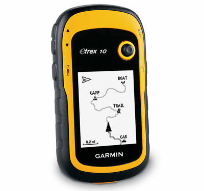
The Garmin eTrex 10 is Garmin’s new entry-level unit in the recently updated eTrex series. It offers paperless geocaching, GPS+GLONASS and advanced track navigation, but has a monochrome screen, limited memory and cannot accept detailed maps (although you can see your track and waypoints, as pictured above).
Related units
- Step up to the eTrex 20 to get a color screen, expandable memory, mapping and BirdsEye topo/aerial image capability
- Going the other direction, the older eTrex H uses a serial interface instead of the eTrex 10’s USB port, and drops paperless geocaching and advanced track navigation
- To see how the eTrex 10 stacks up against other models, check out my Garmin handheld GPS comparison chart
A big improvement
As noted above, the eTrex 10 represents a huge improvement over the older eTrex H. One of the biggest changes is the USB connection instead of the old serial port, which caused a lot of people a great deal of pain. The eTrex 10 also adds paperless geocaching capabilities, so you can have cache descriptions, logs, hints, etc., in the field as you cache. I was also happy to see advanced track navigation on the new model. I’ll go into details on all of those features shortly.
Garmin eTrex 10 hardware
Buttons
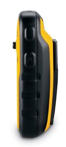
There are six buttons on the eTrex, three on the left, two on the right and one on the front (see image at top of page):
- Zoom in and zoom out buttons – These are on the left and can also be used to navigate menu lists a page at a time
- Menu button – (Also on the left side) Brings up a context sensitive menu; double-tap to access the main menu
- Back – On the right side; moves you back a step in the menu structure
- Power/Light – (Also on the right side) A short tap brings brings up a screen with date/time, battery and GPS status; additional short taps toggle between 0, 50 and 100% backlight; press and hold to power down
- Thumb stick – Located on the front of the device, you can toggle it side to side or up and down to navigate menus and pan the map; press down to enter a menu command or select a map point; press and hold to mark a waypoint
Display
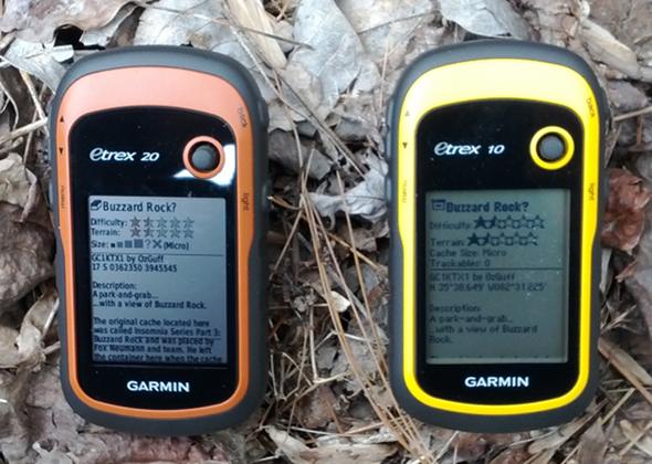
The eTrex 10 has a monochrome and lower resolution display than its color cousins. Generally speaking, I find monochrome displays harder to read in certain conditions, although it definitely isn’t a deal breaker. The device is still quite usable in a wide range of situations and I never really struggled with making out anything on the screen. Here it is compared to the eTrex 20.
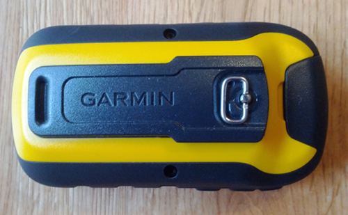
The image below of the rear of the unit shows the mounting spine for a bike mount or carabiner clip (not included with the purchase of the eTrex 10, sad to say). Unlike the Oregon and 62 series, the spine is plastic, which could lead to some wear, and definitely makes it harder to slide in and out of those accessories.
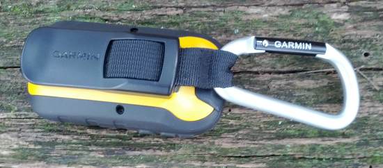
And here it is with the carabiner clip attached…
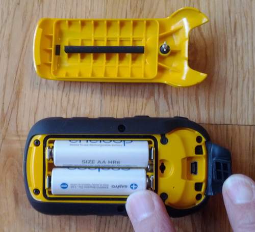
Here’s the battery compartment showing the mini-USB connector under the top rear flap…
Memory
There is no memory expansion slot in the eTrex 10 and Garmin doesn’t publicize the amount of internal memory available for geocaches, etc. My test unit, stripped of any .gpx files, had 2.3 MB available. I can tell you that even a single pocket query of 500 caches can generate a low memory warning.
Garmin eTrex 10 interface
The eTrex 10 utilizes the same interface as the other models in this series. The main menu items are pictured below.
Garmin eTrex 10 features
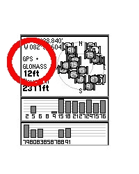
Even though the eTrex 10 is an entry level device, it offers several nice features:
GPS+GLONASS
Theoretically, this will give you better reception, especially in northerly latitudes and (natural and urban) canyons.
Advanced track navigation
On the eTrex 10, you can select a track to navigate and a route will be created. Waypoints are automatically generated for major high and low elevation points, and start and finish; these and any user waypoints along the track are added to the route. I’m a heavy user of track navigation. If I head out for a trail I’ve never traveled before, I do an online search for tracks to load to the device. One advantage of this new track navigation feature is that, unlike typical backcountry route navigation, you’ll get an estimate of actual trail distance rather than “as the crow flies” mileage.
Paperless geocaching
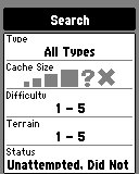
The eTrex 10 is set up for full paperless geocaching support, including cache filtering (shown at right), so you can see the description, logs, and hint, and you can log your attempt (find, DNF, etc.) for later transfer back to geocaching.com. Speaking of which, full access to these features requires a premium membership at geocaching.com. Garmin has an opencaching.com site that is free, but the number of caches is far less than what is found on geocaching.com. Shown below: closest geocaches, geocache description, individual geocache menu, recent logs.
Customizing the Garmin eTrex 10
Main menu item order – You can customize the main menu item order by pressing the Menu button while viewing the Main Menu.
Accessing pages via the back button – Use Setup > Page Sequence for this, but be aware that these pages will disappear from the main menu.
Data fields – You can change data fields on just about any screen that has these; usually you just press Menu > Change Data Fields.
Profiles – The eTrex 10 comes with recreational, geocaching, marine and fitness profiles. You can switch profiles by selecting Profile Change from the Main Menu. Or create a new one by going to Main Menu > Setup > Profiles > Create Profile. Select the new profile to edit the name. Any changes you make in menus or other settings will be retained in that profile. So start changing things! Want track up when geocaching and north up when biking? No problem.
Dashboards – Instead of data fields (and in some cases in addition to), you can select a dashboard for the map, compass and trip computer screens. Choices (depending upon page) may include automotive, stopwatch, small or large data field, recreational, compass, and geocaching. I’ve included screenshots showing a couple below. For the trip computer and compass pages, you access this via Menu > Change Dashboard. For the map screen, choose Menu > Setup Map > Data Fields > Dashboard. The one downside here is the small screen on the eTrex series; using a dashboard can significantly reduce screen real estate.
Garmin eTrex 10 performance
Tracking
The eTrex 10 performed very well in terms of tracking accuracy. For example, in one test I placed the eTrex 10 and Garmin 62s on my pack shoulder straps for an out and back hike. The 62s had tracklog separation errors of up to 28′ when comparing the out and back tracks, whereas the eTrex had errors of up to 45′. This isn’t bad and I wouldn’t expect it to be quite as good as the 62s yet, which has more mature firmware. In my experience, such tests generally improve over time with subsequent updates.
Geocaching
Caveat: I’ve yet to come up with a good way to test geocaching accuracy. There are just too many variables – accuracy of the cache coordinates, satellite constellation variability, terrain, multipath effects, etc.
So having said that, here’s a very unscientific test. After becoming familiar with the unit, towards the end of my testing, I made some cache runs. I set the units down on top of the cache one at a time and recorded the reported distance to cache in feet. The results are shown below.
| eTrex 10 | eTrex 20 | GPSMAP 62s | Oregon 450 | |
| Cache 1 | 10′ | 11′ | 13′ | 15′ |
| Cache 2 | 15′ | 10′ | 24′ | 27′ |
| Cache 3 | 10′ | 10′ | 14′ | 15′ |
| Average | 11.67′ | 10.33′ | 17′ | 19′ |
Battery life
I tested battery life using freshly charged 2000 mAh Eneloop NiMH batteries. The unit was left stationary, under light canopy, with the tracklog interval set to record once every 5 seconds. Testing was done with the backlight off. The rated battery life is 25 hours but in my tests the unit ran for 30 hours and 36 minutes!
Garmin eTrex 10 pros
- Full paperless geocaching support
- GPS + GLONASS support
- Excellent battery life
- Uses mini-USB cable (included) rather than eTrex H’s serial connection
- Advanced track navigation
Garmin eTrex 10 cons
- Monochrome screen
- Cannot display maps
- Limited memory
Conclusion and recommendation
Highly recommended. The eTrex 10 is the best starter GPS for geocachers on the market. You can find this model for just over $110 and that gets you the full set of paperless geocaching features. This combined with the fact that it offers GPS + GLONASS support makes it an incredible deal. The eTrex 10 is a huge improvement over Garmin’s previous entry-level handheld unit, the eTrex H. Backcountry users on a tight budget might want to stick with the older Venture HC, which allows you to load topo maps, but you won’t get paperless geocaching, advanced track navigation or the newer, easier to navigate interface.
More Garmin eTrex 10 reviews
- Consumer-authored Garmin eTrex 10 reviews
have been posted at Amazon
- A video review of the eTrex 10:
I’ll be posting more hands on GPS reviews as they appear, but in the meantime, here are some…
Other Garmin eTrex 10 resources
- The Garmin eTrex 10 owners manual
- Want to see how the eTrex 10 stacks up against other models? Check out our Garmin handheld GPS comparison chart
- An eTrex 10 FAQ
- The official Garmin eTrex 10 web page
- Our handheld GPS FAQs
- New to GPS? If so check out our handheld GPS 101 series; otherwise, here is handheld GPS 201
Compare prices on the Garmin eTrex 10 at these merchants:
- Check the current Garmin eTrex 10
price at Amazon
- Get the Garmin eTrex 10 for a low price at GPS City
- Check out the deal on the Garmin eTrex 10 GPS
at REI.com, where satisfaction is guaranteed and members get 10% back on eligible purchases
- Buy the eTrex 10
direct from Garmin




I need you use a gps to track/tag my photos with the highest possible accuracy – e.g. every 10 seconds. This means that it will save 360 track points every hour. In case if i want to operate for 10 hours non stop it will have to save 3600 track points. given that it has no memory would it be able to provide the data needed? or should i choose eTrex 20 in order to save all my tag points ? especially that i may need them every 5 seconds?
According to the specs, it can hold 10,000 track points…
https://buy.garmin.com/shop/shop.do?pID=87768
If you’re going to clear the track after each outing, it should work. Theoretically. I’d certainly feel more confident with the eTrex 20 though.
thanks. would probably need to buy and try… no point in paying the extra for color display if both can do the same… according to this part of the article it can only hold 500 points?
“Memory
There is no memory expansion slot in the eTrex 10 and Garmin doesn’t publicize the amount of internal memory available for geocaches, etc. My test unit, stripped of any .gpx files, had 2.3 MB available. I can tell you that even a single pocket query of 500 caches can generate a low memory warning.”
No, 500 geocaches would be a lot more data than 500 trackpoints. Probably even more data than 10,000 trackpoints.
Couldn’t you use Waypoint Averaging to give yourself a more accurate coordinate for your geocaching test?
I don’t think it would help when compared to the listed cache coordinates, which were created using a different device on a different day. Or maybe you have something else in mind. If so, please let me know. I definitely would like to come up with a good test for it.
Can I upload routes from mapsource on eTrex 10
Garmin has stopped supporting MapSource, so many functions no longer work with the newer models. You should probably use BaseCamp instead…
http://www.garmin.com/us/products/onthetrail/basecamp
Extremely displeased with the operators manual. For example it says to edit but not how to actually change the data. I just bought this GPS and tried to put in some waypoints and am at the high end of frustration. Am seriously thinking about taking it back and exchanging for a Magellan.
Handheld GPS have a big learning curve. I suspect you would be more frustrated with a Magellan. To edit a waypoint, go to the Waypoint Manager, select a waypoint by pressing down on the click stick. Use the click stick to move between fields that you wish to edit.
i agree with bryan,i have tried for hours to figure the etrex 10 out but get to a dead end the manual is no help,i am returning the unit.
Is this your first handheld GPS?
yes this is my first handheld GPS.i have had GPS’ in my boat and they were easy to use.
I’m taking mine back ! I have been very dissatisfied with it !
I do mountaineering but recently I’ve been trekking in the jungle. Was wondering, will this still work even though I’m surrounded by dense canopies?
Yes, but if you’re travelling large distances, read this (specifically “the airport problem”)… http://gpstracklog.com/2012/01/what-to-do-about-gps-reception-problems.html
I am still trying to figure out how to create a track out to a point and follow it back. Frustrated with the lack of an understandable manual. I have spent hours trying to use this effectively. I have been able to create a waypoint or use the MOB feature and find it, but not follow the exact route back.
Once you reach your turn around point, choose Where To > Tracks > Current Track > Go.
Do you have any idea what the refresh rate is. Is it the standard 1hz? I can’t find any documentation. My indirect question, do you find it responsive at slow speeds?
I have an Excel file that generates coordinates for setting up buoys for a high school rowing regatta. I set them up with a Garmin 76 last time. The 76 has WAAS, but there was just a bit of a lag. It actually worked out pretty well. However, I’m thinking that for $100 the much newer eTrex 10 might do a better job. Any thoughts?
Thanks.
I do not know what the refresh rate is. I personally haven’t noticed problems at slow speeds, but I haven’t checked for it either. The new eTrex series can be a little sluggish when panning the map though. Hope this helps.
Thanks Rich.
The 76 worked pretty well, but the Etrex 10 sounds like an improvement. Worst case, I’m out $100 and have another GPS to my collection. I eventually plan on posting this to a website with a PayPal donation link to the crew team. However, if you are interested, this is how I create a gpx file:
http://dl.dropbox.com/u/18240150/Regatta%20Layout%2010b.xlsm
Very very disappointed with this. Bought this to go geocashing. To basic, graphic are awful. I will be returning it ASAP. Do yourself a favor and buy a different one.
Though I have been an avid hiker for over 30 years, I just purchased my first GPS device, an etrex 10. The directions function descriptions that came with it are so limited as to be virtually useless, thus rendering the device essentially useless. Any advice on how I can obtain a detailed and thus useful description of the device’s functions and how to use them?
Handheld GPS have a big learning curve. I suggest going through our handheld FAQs, especially the GPS 101 series. And we’re here to help if you have questions.
The Etrex 10 is an excellent starter unit as long as you know the limitations. It has only about 8MB total memory max available. It can hold 10,000 trackpoints or up to 2,000 geocaches according to Garmin. However, the lack of memory on the unit means you won’t get both, either you’ll have to reduce trackpoints or reduce the number of geocaches. There is no street mapping, just state boundaries and some city POI. Also another unwritten limitation is the Etrex 10 can only hold 500 separate geocaching gpx files so if you’re downloading geocaches one by one, you’ll run out of space after 500. The battery life is incredible on the Etrex 10, best I’ve ever seen. However, for most people, getting an Etrex 20 is a worthwhile upgrade. The Etrex 10 also tends to show the “low on memory” error at lot, even after loading just 500 geocaches.
Hi just bought a etrex10 for sailing, looking to enter the way points, have entered about 45 so far but only 19 are shown on my etrex, which seems as though I have wasted my time and money if that’s all that can be entered. Any help to find out why I have so few listed would be appreciated. The manual says that you should be able to list a lot more than that.
From the Waypoint Manager, press the menu button, then Sort > Alphabetical. They should all show then.
Thanks for a great review. I have been really on the fence trying to decide between an Etrex 10 and Etrex 20 and the side by side comparisons/photos here have been very helpful!
About drove myself nuts trying to decide which GPS to purchase. Purchased the Garmin E-Trex 10 a week ago. So very, very happy I did.
I use this GPS for walking in the woods and for Geocaching. No roads in the woods so I quit looking at map applications and focused on what I wanted it for. The ability to back track so I don’t get lost and the ability to find a location.
What this unit will do: Set a way point at the start of your walk and when you’re done you can do a GO TO route for a straight line back or you can use the back track and follow the path you just took.
The compass is active when walking. Screen points to North and the compass points the direction you are going. So you have to take a step for it to show a reading. I don’t have a problem with this, I’m going to be moving anyway and if I’m not then I don’t need a compass.
You can choose which screens you want displayed, and the information that’s on them. Choose the text size. Name your routes, your tracks, your waypoints and save them. I drove to work and created a route from the track that was made as I drove. When I back tracked the route going home, the GPS kept showing me being off the trail. I could see it on the screen but was not following the exact route. Thought the GPS was off until I found that driving on the other side of the road put me right on the route. The side of the road that had been used to make the track. That’s how accurate it is, if you’re off your track by the width of a road, it will show you!
I’ve been playing with this for 5 days and the batteries are still going strong. I know it didn’t come with a manual but I knew that before I got it. Saved one on the home computer and read it plus a couple of other points of information regarding the E-Trex 10. It’s a learning curve to use it but not over my head. After using it and getting to understand it, I now find it very easy to use. For 99$ at Walmart this GPS does what I want it to do and then some.
Hi I have a garmin etex10 and we are trying to save the hectares on the area calculation. But it will not let me save the hectares on the map. Will tell me how many Kms it is around the paddock. I can save the paddock size but not into the hectares.
Please can you tell me how to save the hectares on to the map?
You can save the track and then tell it to display the track, and it should show the outline.
Hi there i have the same problem with only 19 waypoints showing i did what u said but when i go to waypoint maneger and press menu i dont get any alpabeticl i get 3 things search near spelling and delete all. How can i access more than 19 waypoints? And if i put in a new waypoint it deletes one of the 19 and puts it there surely you can put more than 19 waypoints…..help pls am gunna drown it
Try Spelling and see if a missing waypoint shows up. I’m betting they are there unless you are out of memory. Do you have many routes and tracks loaded, or is your tracklog full?
How can I just see a screen that shows me my current position in O/S grid Ref format
Setup > Position Format > Position Format > British Grid, then set any data field to display Location (selected).
Gosh I can’t believe how in depth users want their GPS to be and how many different uses. I bought my first Garmin ETrex (base level) in 2001. Garmin replaced it free of charge in 2005 as it had gone a bit wonky. It went again in 2012 but this time they wouldn’t replace it and no wonder, 11 and a bit years use isn’t bad. I am about to buy another and having read all the posts on here will still buy the entry level Garmin. I wouldn’t change to another make as I researched in depth prior to buying first time round and it absolutely suits my purpose. I have been a keen mountain walker and scrambler for over 25 years and used to go out alone. A GPS was bought as a safety net to be used in conjunction with map and compass. I wouldn’t ever want to lose my map reading skills so only use the GPS to confirm my location in inclement weather or on trackless ground. There is no substitute for a map and compass and the ability to navigate acurately using them.
I need to know how to switch to 5 decimals readings for my work ; example N 37 93.34566
W 97 61.23456
its set on 3 now example N 37 93.345
W 97 61.234
WISH i HAD MY OLD MANUAL IT TOLD HOW ; PLEASE HELP ME THANKS CRAIG
Setup > Position Format > Position Format > hddd.ddddd
Do you know, that you CAN download a topo map to your Etrex 10? Now only one map (of Grand Canyon National Park) for Garmin Etrex 10 is published on my site http://etrex10.ru/en/ But in the nearest future I will post a free GUI for creating a sets of topo maps for Garmin Etrex 10.
can hand held garmin gps etrex 10 be used or converted into a vehicle tracker
Depends on what you mean by vehicle tracker. If you mean put it in a vehicle and then track where the vehicle goes, then no it does not have that ability. I am not sure if you could somehow convert it…I kind of doubt you could. If you mean find your way back to your car while hunting or hiking, then yes, it should be able to.
Is there an App which will allow me to transfer routes and waypoints (downloaded from websites) from my Android tablet v.4.0.3 to my eTrex 10?
I have tried various android Apps but none seem to recognise the eTrex 10.
My tablet sees the eTrex as a USB disc and I am able to cut and paste downloaded routes but doing it this way does not allow the eTrex to separate into routes and waypoints to allow them to be accessed through the separate menus. Can I achieve this by pasting routes into different folders?
Also what is the NAV folder on the eTrex for? At the moment I paste everything into the GPX folder – routes, waypoints and geocaches.
Also should I set the interface to USB or Garmin and what’s the difference?
Sorry, a lot of questions, but no answers available anywhere else.
I’m so glad that a stumbled across this site. You seem to know a great deal about this product. I’ll explain the functionality I’m hoping to achieve with the eTrex10. I use Google Earth to examine areas in the back country that I would like to hike to. If Google Earth displays the GPS coordinates of a location I would like to hike to, can I put these coordinates into the eTrex10? If so, would you mind explaining how?
Yes, you can enter coordinates and save them as a waypoint, then you should be able to navigate there. Here’s how to save coordinates as a waypoint. Hope that helps!
Hi, New to E-trex (i have an older model too). i have a very specific query. I’m doing a journey that i have to verify the distance travelled each day.
My watch will run out of battery on GPS mode; how do i use my Garmin to simply measure my distance travelled each day.
i don’t need anything else. a simple notepad and pencil can be used to record and the data can be wiped for the next day’s journey.
i downloaded the owners manual, but I’m struggling to understand it.
can you help?
Andy
how to fix garmin etrex 10 erorr warning! low memory, and can not store the data recording
How to save tracklog from etrax10 to computer.
Hi thinking about getting a garmin e trex 10. Can this device give me a ten figure grid reference. If not do you know of such device that can.
Your help on this matter would be ever so appreciated
Many thanks
Peter
Yes it can.
Setup > Position Format > Position Format > MGRS
easy to use ,hand held but the problem is it gets hung up many times as we continuously keep it working. i took this for taking different waypoints of the jungle during a survey but slow and getting hang many times makes us say. oh god not again !! is there any idea that we can recover deleted files from this gps as there is no memory extension.
thanks
No GPS will work well if you are working under a heavy tree canopy. It can’t get a clear fix on the satellites.
Is the map supposed to show when I am recording tracks and have record and show on map option selected, or does the map/route only show when you are returning to beginning point?
When trying to save the current track on my Etrex 10 I get the message ‘There is not enough memory to complete this operation. Delete routes, tracks or way marks to free space’. The current track is the only track on the device, as I had deleted all the others – and the current track is for a walk of less than three hours.
According to the ‘reset’ screen, Memory used for waypoints is 0%, memory for current track is 5%.
Any suggestions as to what to do?
Device is less than 18 months old.
Same
My eTrex Legend died and I think to replace with an eTrex 10. One question – Can I download tracks from the eTrex10 using MapSource. I don’t need any other feature. Just to be able to download tracks either directly into MapSource or separately in a format that can be opened by MapSource. Is this going to be possible ?
Because Garmin discontinued Mapsource, I don’t think it will be fully compatible with the new eTrex units. Garmin has pretty much switched everything over to BaseCamp instead.
Tested with my new eTrex 10. Mapsource can download all data from the unit directly without problems.
Hi I’m new to use of GPS and have bought a etrex10 for a assignment and when locked into satelllites it displays in N and W how can I see this in N and E? Is there a way to change settings? I read in another forum that waypoints display in N and E, so is this the only way to get N and E? I live in Queensland Aust. and I believe I have set the settings correctly in GPS but would like to have N and E on satellite screen if possible as I have to take photos as part of assignment showing N and E.
Jason.
Hi all, update is I was wrong with on screen info on satellite seen page it displays S and E, I have probably worked out now that the gps is referencing off Brisbane and I am in ipswich Queensland Australia hence why S E of Brisbane. But part of assignment is to take photo of gps in N E coordinates. I go to way point average menu and start new one but still comes up S E cords. What do I need to do to get GPS to display N E? I’m thinking somehow I need to reference off a point other than Brisbane?
I’m in need of help and would like to know what to do?
Jason.
You are below the Equator hence why GPS shows your latitude as “S”. You are east of the Greenwich Meridien at 0-degrees so your longitude shows as “E”. GPS position is defined relative to the Equator and Greenwich not a specific point on it (i.e. not Brisbane).
I turned my etrex10 on and found a spot on mark waypoint called map. It shows the distance walked while on foot, bike or car. I set my car mileage to zero miles and my etrex 10 to zero feet. After 4 miles in my car, my etrex reads 3.4 miles. Why are they not the same mileage?
Perhaps the device has measured nautical miles rather than standard(land) miles?
Hey there.
Really hoping you can help. Does the etrex 10 have the ability to export your recorded tracks and waypoints in GPX format to your computer? These would then be inserted into ArcGIS and the folders used to create an output map.
Thanks in advance!
Hai there,
Can I use basecamp to plan my trip, make a route map, and transfed to my etrex10?
Thanks a lot
etrex10: I don’t see ‘Where To’ in main-menu. But I get to WhereTo page auto’mly from CreateWaypoint, & MoB – GO.??? Is this correct functionality?
Or have I deleted the WhereTo from main-menu? If so, how do I get it back?
Also … no MoB mention in manual ??
Hi,
Never had a GPS
My needs are simply walking around the boundaries of forest patches (many times under the canopy), come up with a map showing shape, size and be able to place it in Google Earth.
Properties are 50-400 acres, each. Consider 25-50 waypoints along the perimeter, for accuracy.
Do like 20 a year.
Can the Etrex 10 do this?
We have just bought a 20 acre parcel of land. If I have the longitude and latitude of each of the corner markers, can I enter this into the gps for it to lead me there…. Or will it show me my current longitude and latitude and update as I walk the property? Thanks 🙂
Can the battery charged in the device itself through the data cable?
Does the garmin etreck 10 show property lines
Hi,
I’m considering buying the etrex10. All I need is just to track my hikes and tell me the distance, altitude, time, etc. No maps, no geocaches etc. Maybe make a waypoint every now and then. On garmin site it says that it can hold 10.000 points or something like that, can someone tell me how many hours of hike is that? Thank You.
No.
If you put in 10 waypoints every hour, it’ll take 1000 hours of hiking until you don’t have any more capacity. If you make a waypoint for every mile of a hike, you’ll be able to walk 10,000 miles before you run out of waypoints. If you walk at an average pace of 4mph, you’ll walk for 2,500 hours before 10,000 waypoints at 1-mile intervals are used up. Since all of these figures are variable there’s no chance that anyone can answer your question unless every variable is given for every moment. Don’t bother trying to do so.
You need the Summit model for barometric altimeter.
Thank you Rich, didn’t know you can set yourself how often it records a point.
hlo dear,plz tell me can we use this gps while driving a car. can i shows us route in way we go. thanks.
Shall any body tell as how to see Lat- Long in degree decimal? I will be thankful. Please tell step by step.
Thanks
Sunil Borwankar
9301821233
Betul
My problem,
How Do I record a position, with the intent to use the E trex 10 to return to that exact? position????? Please detail each instruction step. Thanks. Brian S.
I have a GARMIN etrex 10 that I have used for sometime now. I have a problem. When I ON the device and allow for a while, a message will appear like this “WARNING! Low memory. Delete routes, tracks, waypoints to free space”. I have respected this instruction several times but it is still appearing. when I struggle to save any data like a waypoint, route, etc, this information will appear “”There is not enough memory to complete this operation. Delete routes, tracks or waypoints to free space”.. I have also respected this instruction to no avail. This information is still appearing and I can not mark any waypoint, tracks or routes.
I need help. I am writing from Cameroon where there are very limited users of this device.
I had a similar problem a couple of years back. Garmin Product Support suggested updating to the latset software, then doing a Master Reset by turning the device off, pressing Page, Enter and Power buttons simultaneously, and releasing them once the ‘Do you really want to erase all your data’ messahe appears, and selecting ‘Yes”
As I recall the problem was to do with the deleted files not actually being moved off the garmin device until the ‘trash’ folder on my computer was emptied.
So if Master re-set doesn’t work, try connecting the device to your computer, emptying the trash, then deleting tracks &c.
It worked for me!
Good luck,
Jonathan
There is not enought memory to complete this opreration. Delete routes, track, or waypoints to free space. “Warning! Low memory Delete routes, track, or waypoints to free space”. But in menu Setup/Reset: Memory used: 0%; Clear current track: 0%.
I cant do any thing ….
My Garmin only show Menu Setup.
How to fix this problem…. Plz!
Just bought the eTrex 10, my first GPS. Mostly all I want to do is geocache. I figured out how to download caches from geocaching.com but haven’t a clue how to get it to tell me how to get to the cache. Help.
My job is to visit different sites in the villages and country side, plus within cities and towns in India and place a report about the feasibility of the site based on certain given parameters. It is in this aspect, I have to mention the exact latitude and longitude of the site visited. Beyond that I do not need any other GPS related information. Please suggest the cheapest model available to serve the above purpose. Warm Regards.
“I have to mention the exact latitude and longitude of the site visited. Beyond that I do not need any other GPS related information. Please suggest the cheapest model available to serve the above purpose.”
——
Hi Sumul!
Which GPS unit did you decide to purchase? I’m in the same boat and hoping Rich or someone else could advise. We just need latitude, longitude, elevation and accuracy rating. Is there no simple accurate GPS readers for around $30 to $40 that does this?
Nice review, Rich!
Can you – or anyone here – tell me what would be a good simple GPS receiver for a small Social & Market Research company? We simply want to be able to have a second (backup) GPS reading for when we conduct mobile data collection on our Android smartphones (low-end Samsung Galaxies) out in the field using Open Data Kit or Survey2Go.
Some clients are complaining of a few inaccurate GPS readings when they try to verify our results.
Would this Garmin eTrex 10 (now $79) allow us to capture more accurate GPS data compared to a standard smartphone with builtin GPS? Is this ‘good enough’ for our business – taking into account that we don’t want to spend a fortune on GPS receivers either.
Are there GPS receivers that simply show elevation, longitude, latitude & accuracy level? I don’t think we would need any of the other features mentioned in this article.
Many thanks!
Hello i am very greatefully today as i solve my problem, Of This “WARNING! Low memory. Delete routes, tracks, waypoints to free space”. I have respected this instruction several times but it is still appearing. when I struggle to save any data like a waypoint, route, etc, this information will appear “”There is not enough memory to complete this operation. Delete routes, tracks or waypoints to free space”..
Same quiestion.