If you’ve ever gone geocaching you’ve undoubtedly found yourself thinking about hiding your own geocache. You’ve probably said, “I know somewhere that would make an excellent hide…” Maybe you’ve wisely waited until you have a number of finds under your belt. Maybe your area is so saturated with geocaches that you’ve yet to set one. Or maybe you’ve set a few and had geocachers come back to you and say that your co-ordinates are way off. If so, then this month’s article on getting accurate co-ordinates when placing geocaches should be of use to you.
The first thing you need to do is to let your GPS settle. This sounds obvious but it is surprising how many people hide geocaches at the same speed they find them, rushing in, hurriedly hiding the geocache and then take a single quick reading before heading off. Placing a geocache is going to take some time if you want accurate co-ordinates.
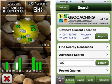
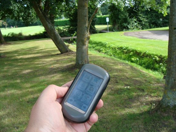
Nearly every GPS application whether on a dedicated device like a Garmin Oregon or a smartphone app like the official geocaching app, will tell you how accurate your GPS is down to a number of feet or metres. Depending on your hardware there will be a limit as to how accurate your GPS can be.
It’s worth considering, if your GPS is less accurate than the current models on the market, asking a fellow geocacher if you can either borrow their device or if they could come with you to set your geocache. If you don’t know other geocachers very well it might be hard to convince them to lend you their expensive equipment, but most areas worldwide have area associations or regular events. Geocachers are generally welcoming to new people and willing to offer help and advice wherever they can. One piece of advice though: if you do take a friend or another geocacher along with you to help place the hide, do not make the mistake I have seen some first time cache-setters make, and allow them to claim the geocache as a first to find. Everyone plays the game differently, but that sort of thing tends to be universally frowned upon.
In areas of patchy reception (such as a forest with dense foliage) a lot of GPS devices will also estimate your position based on your trajectory. If you’ve ever been caching and stopped only to watch your GPS continue as if you were still moving it’s likely your device has this feature.
Your GPS will naturally get better accuracy the longer it is left on, so switch it on long before you reach your hiding spot. Once there, put your GPS on the ground next to you whilst you hide the geocache. This will give it time to settle and give you a good result.
You may want to write the co-ordinates down or take a waypoint depending on your GPS software, but either way, take a reading and note it somewhere safe for later.
Next, pick up your GPS and walk back the way you came for a couple of hundred feet. If your hide is in a wood or covered area you may want to extend this until you emerge under clear skies. Wait for a couple of minutes then slowly walk back to the hide location and pause for a couple more with your GPS over the hide before taking a second set of co-ordinates. These pauses are important to allow for your GPS to settle and cancel out any predictive location.
What you now need to do is walk a similar distance there and back in a different direction. Remember to take your time. There often feels like there is an instinctive need to hurry, perhaps driven by a fear of being spotted, but being slow and methodical will lend itself to future logs praising the accuracy of your co-ordinates.
You need to repeat this four or five times, going off in a different direction each time, waiting, walking back and then after the GPS has settled, taking another reading. In cases where it isn’t possible to go in a variety of directions, don’t be afraid to go walk to an outlying point you’ve already visited and then return. The idea is to get the co-ordinates changing before letting them settle again.
At the end of this exercise, you will have a number of similar sets of co-ordinates. Some devices have the ability to average your waypoints but I prefer to do it by hand. Most sets of co-ordinates will only differ on the last couple of digits on the Northings and Westings, so if I see one reading that’s massively different, I like to remove it from calculations.
I split the Northings and Westings out and deal with them separately. I look at all my various Northings and come up with an average. If you have three Northings that end 323 and one that ends 324, it makes sense to go with 323, likewise if you have two that say 322 and two that says 324, 323 sounds like a logical choice.
With this done for both the Northings and the Westings, you should now have a co-ordinate, but I still make one final check.
I will go onto Google Maps and type in the co-ordinates and make sure that the location it gives me matches my hide. I have been known to adjust my co-ordinates by a single digit to give, for example, a better idea of which side of a road to be looking.
The thing to remember is that your co-ordinates will never be perfect. Different devices with different chipsets and hence different levels of accuracy means you can never guarantee even with top notch co-ordinates, that a user won’t go to the wrong tree. Part of that is the fun of geocaching, but always keep this in consideration when writing any clues. “Base of tree” when in a forest with dense cover, lots of possible candidates and poor GPS accuracy doesn’t always lead to the most complimentary of logs.
Do you have any tips for getting good co-ordinates when setting your geocaches? If so, tell us about them in the comments below.


Newer Garmin units (for sure the GPSMAP 60 and 62 series) also allow you to “average” waypoints – essentially collecting multiple readings and averaging them to improve accuracy. This feature can be found in the waypoint creation screen.
I’ve always worried that it would include my outliers. Plus I’m a bit of a maths geek so I like to do this by hand
Garmin’s take on waypoint averaging from awhile back:
http://garmin.blogs.com/softwareupdates/2009/04/waypoint-averaging.html
Thanks for the link!
i have and use an external antenna. that sucks in grat satillite signals. I have it monted on a good ground plane and that is mounted on a dowel that gets it up past my head. then when I get to where i want to be. I but the pack on the ground with tht eantenna pointing straight up and let it sit for fifteen minutes or so. I make note of that reading then turn on the averaging system and use that according to garmins methodolgy.
It works for me.
Oh I have a garmin Montana 650, and a GPSMAP 60Cx. Both can use the external antenna.
Hey, if it works for you! I’m sure my methods are overkill as well, but I’ve seen too many caches that were notably out – namely a micro in ivy in a forest 200ft+ out. Now that was a FTF to be proud of! 🙂
It’s probably overkill, but when sufficiently caffeinated, I’ve been known to use survey planning software for this sort of thing. You can find them as standalone packages, such as produced by Trimble, or web-based versions such as these:
http://www.ashtech.com/gnss-planning-17876.kjsp
http://www.navcomtech.com/Support/Tools/satellitepredictor/main.cfm
Lower DOPs are better, read the wiki:
http://en.wikipedia.org/wiki/Dilution_of_precision_%28GPS%29
Looking at the various graphs produced by these tools will help you learn that it is not alway about the number of satellites visible, but also the geometry, or layout of the satellites in the sky, that contributes to the accuracy. The elevation mask ignores satellites below a certain angle from the horizon. These low-on-the-horizon satellites would be useful for maximizing good geometry, but are more affected by error-inducing atmospheric delays than other birds.
I love it! No such thing as overkill and I love hearing the lengths people go to for their coords
Nice article. Thanks Adrian.
Glad you enjoyed it!
Thanks for the help. Looking to hide my first cache and will be following this guide.