The Rand McNally Foris 850
Well this is a surprise. Rand McNally has just announced their first handheld GPS, the Foris 850. The Foris is a result of a partnership with Falk Navigation, a European manufacturer. The Foris 850 appears to be based on their Lux 22 model.
Rand McNally describes the Foris 850 as follows:
Built for hiking, biking, geocaching, and other outdoor activities, the Foris™ 850 is “trail ready” with millions of miles of high-quality street and trail maps, a sturdy bike mount, and an easy-to-use interface with on-device help…
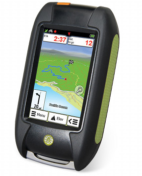
The Foris has a 3″ touchscreen (240 x 400 pixels) and comes preloaded with contour maps (no mention of scale) and over 5 million miles of US roads and trails.
One unique feature is turn-by-turn voice guidance on trails, although I suspect many users would want to disable that feature. The device can also “create navigable routes from breadcrumb trails that the user creates via the TrackNav feature.” This sounds similar to Garmin’s advanced track navigation. Hopefully the Foris can utilize standard .gpx track files for this.
They cite the inclusion of multiple preloaded US trail databases such as the Rails-to-Trails Conservancy, National Park Service, National Forest, National Wildlife Refuge, and state park trails.
A Rand McNally web portal, dubbed Trailhead, allows users to “download, store, and view their hikes and rides on desktop maps and more.”
Other listed features:
- The ability to compare three alternative routes, with elevation profiles
- Paperless geocaching through integration with geocaching.com; all descriptions, hints, logs, difficulty and terrain level on device
- Storage capacity for up to 7,000 waypoints
- A barometric altimeter
- Anti-glare screen protector, 8 GB internal memory, bike mount, and batteries included
The Foris 850 is expected to be available this April at a suggested retail price of $399. The company also notes that it “is anticipated to be the first in a line of handheld products from Rand McNally,” a company known more for their RV and truck devices when it comes to GPS.
Click here for the full news release.


Will be interesting to see a head-to-head with the new Oregon 600s coming out about the same time.
If the feature list included “Ability to make maps from publicly available data.” I’d get one. Making maps for my Garmin for free is what keeps me in the Garmin camp. Why doesn’t any other manufacturer realize this ability sells units? Instead they think “How will we make money off maps if people make their own?”. Well, I dunno, ask Garmin.
Ok, ok, I’m calm now. 🙂
Good point! I use the free topo maps at GPSFileDepot for my Oregon 450. I’d love to see a unit that I could connect to the computer and just download OSM data (streets and trails!) as well as other data.