Hands on with the Garmin 64s
When the Garmin GPSMAP64s was announced this winter, I was pretty excited. The older 62s is my go-to handheld, and I was psyched to see new features like GLONASS, smart notifications and preloaded geocaches. So let’s take a closer look at them…
GLONASS
The 64s offers not only GPS, but support for the Russian GLONASS constellation as well. GLONASS has a reputation for being helpful in northerly latitudes and canyon-like environments, so I was curious to see how well it would perform in the the absence of those conditions. All my testing was done in the southern Appalachians.
I was a bit surprised to see that it actually seemed to outperform my 62s. In the image below you can see a place where the 62s (in red) threw a few stray trackpoints on a straight stretch of fire road.
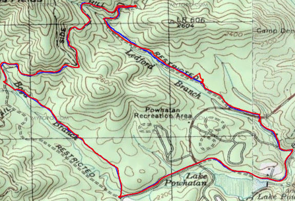
The 64s tracklog is blue; the 62s is in red
The same thing happened in a more canyonesque environment too…
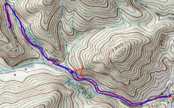
Once again, the 64s tracklog is blue; the 62s is in red
The above image is from an out and back mountain bike ride, which allowed me to look at track separation — how faithfully the unit records the same track on the return portion of the trip. The 64s had a bit more tendency for track separation, but the glaring stray trackpoints error of the 62s bothered me much more.
Still not convinced? Check out the 62s’s tendency to wander at two breaks I took on another ride (below).
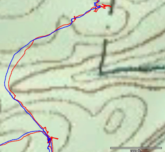
The older 62s (in red) track displayed more wandering at rest breaks
I did not have time to do any waypoint or geocache testing with the 64s, but I was impressed with its track recording performance.
Preloaded geocaches
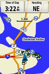
Preloaded geocaches
With 250,000 preloaded caches from geocaching.com, you’re likely to always have some nearby caches loaded when you travel. The screenshot at right shows coverage in downtown Charleston, SC.
Smart notifications
Owners of an iPhone 4s+ can get texts, emails and alerts, right on the screen of their 64s. The Bluetooth-enabled 64s also allows you to use the Garmin Connect mobile app to share your location via LiveTrack (as long as you’re within cell phone range).
I’m an Android user, so I didn’t get a chance to test this feature out. According to a recent news release from Garmin though, this feature is coming to Android users.
Buttons vs touchscreen
Should you go for a touchscreen like the Garmin Oregon series, or a unit with buttons like the 64s? Here’s a couple of use cases where they may make a difference…
Mountain biking – With the buttons found on the 64s, you can change screens on the fly, without having to take your eyes off the trail. This would apply to many other fast moving trail sports such as snowmobiling, etc.
Entering waypoints – No doubt about it, if you’re doing extensive naming of waypoints in the field, a touchscreen is much faster than the virtual keyboard found on the 64s.
Other performance notes
My 62s has a bad habit of picking up my prior location and including it in the current track, even after I clear the tracklog at the trailhead! I never saw this occur on the 64s.
Mileage and elevation gain data appeared to be accurate, generally with 1-2% of the numbers reported by my 62s.
What’s missing?
The interface is nearly identical to the 62s, which means less bugs but it also means you won’t see things like the new style of track manager found on the Oregon 600 series.
All the returning features
I won’t go into all the details here, but you’ll find many of the features that have made it worth upgrading your handheld in the last few years — compatibility with BirdsEye satellite imagery and topo maps, Garmin custom maps, advanced track navigation, paperless geocaching and activity profiles.
Conclusion
While I did not have the time to put the unit through the rigorous tests I have in years past, from what I have experienced the 64s has perhaps the most mature firmware of any new Garmin handheld released in recent years.
The only bug I’ve noticed is the need to go into settings to manually disable and re-enable my tempe temperature sensor each time I use the 64s. Hopefully that’s a bug they can straighten out in short order.
Related units
- Drop down to the GPSMAP 64 and you’ll lose wireless data sharing, the barometric altimeter, triaxial electronic compass, smart notifications and live tracking
- Or step up to the GPSMAP 64st to add pre-loaded 1:100,000 scale US topo maps to the 64s feature set (but with all the free maps available, there’s little reason to spend the extra bucks)
- Stick with the older 62s and you’ll lose GLONASS support, smart notifications and the preloaded geocaches
- To see how the GPSMAP 64s stands up against other Garmin models, check out my Garmin handheld GPS comparison chart.
Other Garmin GPSMAP 64s resources
- The Garmin GPSMAP 64s owners manual
- Use this chart to compare the 64s to other Garmin handheld GPS models
- The official Garmin GPSMAP 64s
web page
Compare prices on the Garmin GPSMAP 64s at these merchants:
- Check the current GPSMAP 64s price at Amazon
- Check out the deal on the 64s at REI.com
, where satisfaction is guaranteed and members get 10% back on eligible purchases
- Buy the Garmin GPSMAP 64s direct from Garmin


Regarding touch versus buttons. Put some heavy winter gloves on (real ones) and see how the buttons work for you. For me, it’s an exercise in frustration and the glove has to come off to do anything useful. Touch screen I can use a stylus or other pointy device to do complex entry and not remove the gloves.
Have you tried filling the track log up to see if it flakes out like the Montana and Oregon (450)? Once they hit around 10K points, they will randomly stop displaying portions of the active track. Only solution I’ve found is to run them at regular recording method/auto and let them auto-archive. Quick way to make them fail is put the track down every 1 second and go for a drive in the car.
I will try it out before sending it back to Garmin.
That is not a bug Jeramey.
All current Garmin GPSr will auto-archive your current track log when it nears 10,000 points so you never loose any information or track detail like you did with older devices. When this happens, a large portion of the current track log is ‘archived’, and archived tracks can not be displayed on the map screen.
The portion of the track log that disappears from the map screen i sno longer the active track log, and thus, is not displayed by default. You can, however, unarchive it and set it to show on map if you desire.
Ah, I misunderstood what he was saying. That makes sense Atlas. Thanks for chiming in. On a related note, here’s a great way to manage downloading those split tracklogs.. http://gpstracklog.com/2013/08/downloading-split-tracklogs.html
Also, the portion that is archived is from the oldest part of the track — that way you can still see your most recent activity in the current track log.
Garmin claims the 64 series “comes with a built-in worldwide basemap with shaded relief.” The lack of shaded relief with free vector maps was one reason to go with the “t” version in the pre-6xx Oregon line. Is it possible to let the shaded relief from the basemap display at the same time as topo lines from a free vector map? Thanks.
Apparently not. If I set Shaded Relief to Auto I see no background. If I set it to Show if Available, it just puts a solid brown background on the map.
Thanks for checking Rich. Just to make sure I wasn’t imaging it being supported, I set my Oregon 400t to “Show if Available” and only turned on a free vector map and verified I did see shading along with the topo lines.
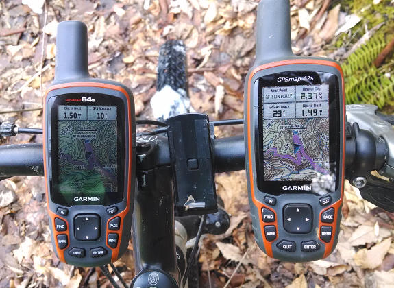
Thank you Rich for the review.I notice in the photo of the 2 GPS on the handle bar of your bike, that the screen of the 64S is darker than the 62S….Is it true or is it because of the sun angle ?
I think it was just sun angle. I never noticed it and used them side by side on each test.
You mention the newer track log manager from the Oregon 6xx is missing, are there any other new features the Oregon gained that didn’t make it to the 64?
Sure… dual orientation screen, customizable shortcuts, tabbed menus. I’m sure there are others too.
How long before we see a camera on this series?
Or is this wishful thinking…
Purely a guess, but… announced late May/early June, available anywhere from immediately after announcement to 4 months later.
I have the same gut feeling.
I was slightly surprised that wasn’t part of the series to begin with.
I just checked and it was a full year between announcing the 62 series and the 62s(t)c.
Was it just my imagination or does the 64s feel slightly faser when navigating menus? Did you notice this at all?
It seemed to be a bit faster. Perhaps they upgraded the processor.
I’m curious, one comment on Amazon states that the new 64 models will not allow “unlocked” maps to be loaded (whereas the 62 models did) Is this true?
I had no problem with Garmin unlocked maps (like their 24K topo series) or with third-party maps.
I’ve had no problems loading Garmin City Navigator NT and the gloriously free Northwest Topos (plus the Building Footprints) from switchbacks.com. The Topos will not show if CN is on (no different than the experience with the Oregon 450), but generally when I really need them, I’m not in a car.
I am curious if any of you have had problems with the unit seizing up, especially when switching menus. It’s happened to me in the field on two separate occasions (three times today – sigh), and the only remedy is to pull the battery. Worse, doing so will often result in losing all of my geocaches.
Curiously, I just found a thread on groundspeak’s forums describing the freezing symptom: http://bit.ly/1iHKiDP
In the thread, it’s pretty reproducible if you’re switching menus and the compass is on that list (which for anyone geocaching, would likely be).
Freezing issue is fixed by Firmware version 2.80.
I bought a 64s after finally breaking my 60CSx. I use the GPS primarily for geocaching/hiking, and frustrations are now numerous.
1.) Biggest annoyance: essential no user manual – shows little more than how to turn on the machine.
2.) Preinstalled geocaches (250,000) when I’ve already found 2,000 in my area. How to rapidly delete already found geocaches???
3.) There is no “Delete” option for preinstalled caches through GPS keys. Only a “DONE” option – use it to “delete” and the machine may indicate it as a “found”.
4.) Geocache “pocket queries” transfer as Waypoints. I need FIVE (5) GPS keys entries to delete one: (icon)-> click Enter; (go)-> click Menu; (edit waypoint)-> click Enter; (Go) -> click Menu; (delete) -> click Enter.
5.) With the 60CSx, a simple click on Find produced all recently viewed caches. 64s’ “Find” just shows “Find Another”, which leads to Menu which leads to Recent Finds (a chaos of deletes and edits, etc., including unwanted Preloads), or Waypoints (okay), but confusing…
Why confusing? I am to opt to have GPS identify points as Titles or GCxxxxx identifers. I MUST use title for one and GC-code for the other, or I’ll be unable to differentiate between the two on the GPS map. So “Find Another” -> Waypoint or Geocache? Must use Menu, and goto subcategory Geocache or Waypoint… Again, we can delete Waypoints (come on – they’re geocaches! most of the time), but not Geocaches.
6.) BTW, with the 60CSx. to delete a Waypoint/geocache was easy: click on an icon and select “Delete”. To delete a downloaded “Waypoint/geocache” we must now click on Icon -> (go) click on Menu; (edit waypoint)-> click on Enter; (go)->click on Menu; (delete)-> click in Enter.
7.) Most all pocket query Icons have a Preinstalled geocache underlying them. So, when I click on many caches, a selection appears at the top of the screen. The machine freezes till I’ve made a selection. I cannot simply move the curser on to another cache without clicking on “Quit” or selecting one of the choice. Annoying, as I’m often clicking on icons to search for a particular cache and help orient myself – with no intention of selecting either. Result is SLOW.
8.) It’s hard to know where to begin with my critiques. In brief, the 64s SLOWS down and CONFUSES nearly everything!
9.) Good points there are. Miraculously, logs seem updated every day! It’s great to be able to read logs, etc. – though only on Preinstalled Geocaches (not so-called Waypoints).
10.) If we view the 64s Internal Storage, through Windows or Basecamp, we see the GPX subdirectory. But there is NO INFORMATION regarding deleting or editing. With Basecamp, we can Import 64s data to view on Laptop, but I’ve found no way to edit the GPS preinstalls.
11.) The Birdseye Maps are a good addition to 64s. BUT – stupidly, the GPS original settings caused background to dim as night approached, etc. – making anything impossible to read. Easy to correct, after 20-minutes of keyboard hunting! Preinstalled Geocache icons are green, providing almost no contrast against Birdseye landscapes, such that I sometimes fail to see icons I’m looking for, etc. Waypoints, on the other hand stand out well.
12.) I’ve not yet found the option for displaying found Waypoints as boxes with open lids – forget about modifying Geocache icons! How much time can one spent clicking through a maze of subdirectory options!!
13.) It’s great having storage for 5,000 Waypoints, btw.
14.) Mysteriously, my GPS, if left on (e.g., by mistake), may announce I’m arriving near Waypoint X in the middle of the night, though I’m still a mile away!
15.) I’ve had problems with Basecamp. Attempt after attempt through Edit or Devise to transfer files (edited or not) to the GPS fail. So, generally, I use Basecamp to setup Birdseye, and Mapsource to transfer geocache/waypoint data.
15.) Battery life is shorter with 64s than with 60CSx – as is logical, given the greater data exchange.
16.) Each visit to Basecamp or Garmin Express (I’m unsure which) seems to result in Updates. This should be great (given the room for software improvement), but with NO USER MANUAL explanations, one can’t but wonder what the heck’s going on!
17.) No one, but NO ONE at REI knows anything about the 64s at this point in time, other than to lament that there’s essential NO user manual and advise customers to call Garmin.
18.) I would have to take notes while out in the field to explain more concerning the HUGE keystroke inefficiency the user faces and the fact that after a painful loss of time and patience one’s not sure anymore of what the GPS is now guiding toward, if anything…
19.) The one good message. I sent my old 60CXs back to Garmin for repair (at $110) – and I REALLY appreciate that! That machine was perfect, efficient, and for $110 a much better deal than a new 64s… though I would miss the logs – though I have over 2,000 on the machine that I wish I could erase! And I wish pocket query updates would update the preinstalls. For instance, if I created a pocket query of “Founds” through Geocaching.com, might it wipe out the Preinstalls for those items?
An update: at the insistence of others, I again hunted for a YouTube helper.
1.) Best I found is for beginners. Only shows how to geocache using the preinstalls – i.e., “How to begin geocaching”, not “How geocachers can cope with new GPS 64s”. Also assumes one selects from a list of caches on basis of distance and difficulty. I select hikes and interesting spots – need to select from screen map (that’s where keyboard inefficiency hits). I’m not interested in urban caches on postboxes and lampposts
2.) I turned on my machine to check an item mentioned in YouTube. GPS announced I was arriving at GC3R2B7, though I haven’t moved from my kitchen table for the last hour and I’m 1.17 miles away and have no intention of going there – it was just the last point I clicked on.
3.) My reason for turning on the machine? I was curious – just wanted to check on number of caches in the Detroit area (I live in Nevada). Loads in Detroit. I don’t plan on ever visiting there. I may go to France and Norway. Maybe some of the 250,000 could be a help there, I don’t know. There are very few (very few) for the Lake District of Chile – a fun area… Of course, I’ll use pocket queries, and those areas with only a few preinstalleds may be better off!
4.) Note that as any dummy knows who’s done any geocaching at all, there are Puzzle Caches, Virtual caches, Letterbox caches, Multicaches, etc., etc. To simply announce on a packing box or in an add, “250,000 geocaches” borders on non-sense!
5.) Well, on the bright side, if I ever get stranded in Cairo, Bagdad, New Delhi, Ulaan Bator (looks great!) or anywhere in China, and have no Internet connection for a pocket query, I see that my machine storage has loads for those areas and more that I might go for (though very few for West Africa)! A real selling point! Right? Now that’s a reeeeeal selling point!
Try deleting the .ggz file to get rid of the preloaded caches.
Isn’t it absurd to spend $400 on a machine whose user interface is clumsily split more or less evenly between Geocaches and Waypoints and totally abandon one side? Then, the lack of any intelligent user manual: three years from now, how many of the preloaded geocaches will still be active? Can I presume Garmin updates delete archived ones and load in (maybe with some geographical bias) new ones? Will they issue software updates? I was the first customer to purchase one at Henderson, NV’s REI. Maybe REI staff will someday master the GPS interface? I should receive my 60CXs back today from Garmin repair. I can use it as my primary and the 64s as a backup and a potential log/description resource whenever I actually hike out for some cache included in its preloads. Erase the preloads, and half the UI will be void and unusable – at least as far as I can see, having no useful manual.
I’ve just about adapted to the 64s. I no longer use MapSource: BaseCamp seems an absolute must. I’ve clicked Done on couple hundred Preinstalls. To verify transfer of a Pocket Query still requires some cross-checking, as success is not confirmed by the software, and with all the Preinstalls, the addition of new icons is not always obvious. Locating caches in the 64s still seems clumsy, compared to the 60CSx – caches entered manually wind up as Waypoints, and I s.t. need two searches to locate a cache reference. Battery life seems very reduced in comparison to 60CSx. Otherwise, the huge, huge, advantage is the access to Descriptions, Hints and Logs, and the ability to load in 5,000 caches through pocket queries. I’ve had no problem with machine’s functioning. Orientation is still quite confused after leaving a car – can take maybe five minutes to stop adjusting for speed differences; and as with the 60CSx, can send me in endless circles when under trees or on boulder-strewn, open plateaus. The Birds Eye and background maps are an advantage over the 60CXs – a big advantage, actually, e.g., recently steered me around a canyon. I needed three attempts to load an individual Geocache through BaseCamp recently – I eventually found there was a name clash with another I’d entered manually (a Waypoint) – even though MapSource could load in 500 duplicates within Waypoints.
Oh well, the 64s adds some more challenge to caching – and, as said the extra data is great.
I went out for a 7-mile hike yesterday. The area required circumvention of canyons, some trick crossings, etc. On the way back, my Track disappeared from my 64s screen! I’d left my wife a mile and half back. If I hadn’t set various Waypoints during the hike, I don’t know how I could ever have found her again. One of us would certainly have wound up calling for rescue. I felt the problem began when I deleted one of the Waypoints and clicked on Done. From there, the 64s only showed the quarter-mile behind me, as I went, erasing segments beyond that at near random. Oddly, the highway “Track” to our parking remained intact. This Track-disappearance problem has occurred to me once before, but on that occasion, I located a ranch road, and portions of my inward Track reappeared off and on as I zoomed in or out. Oddly, performance seemed affected by satellite reception.
An additional note to my Track problem. Now, sitting at home, I see all of yesterday’s Track, including some of my misguided wanderings caused by the 64s’ loss of Track display. In a dense forest and canyon setting, the 64s can be dangerous, especially as evening is approaching and there’re miles and canyons to deal with.
Yet more problems. I geocached across an area of Colorado. After each find, I of course clocked on “Found” and “Find Next Closest”, But as well, I clicked on menu->menu->geocaches->Show Found to ensure that the found cache appeared in the list, so that I could enter all my finds upon return to my hotel room. Note that on occasion, I have to reenter “Go” and “Found” and “Find Next” again to get the machine to add a found cache to a list. Well, on return to my hotel room, the 64s had somehow deleted all data from the above-described “Show Found” list. (Note that if not currently in “Go” mode for some cache, I have to click on menu->menu->geocaches->Show Found” to produce a list, but such lists outside of “Go” mode order Founds by Distance from Current Location, completely regardless of date, so that it is difficult to pick out those found on any particular date.
So, I began maintaining manual lists as I went. I have not encountered a repeat of the above Wipe-Out of a day’s cache finds, luckily, but can’t count on any future luck.
I now understand (I guess) the total dependence of this machine on BaseCamp. After adding cache data from Death Valley all the way up to Williston, North Dakota, I thought it wise to delete old cache data. There is no Delete Cache option as I had on the 60CSx. I can delete through BaseCamp, but I then receive a warning: “Birdseye View will be deleted. We advise you create a backup copy” (or some such wording. And it must have taken 15 minutes for my machine to complete its “Loading Waypoints, Tracks, etc.” phase when it next booted up.
In brief, the 64s’ conveyance of cache Descriptions, Logs, etc, is a vast improvement over the 60CSx, but I now need to go through a labyrinth of clicks to get to the most obvious data, many desired actions are totally unavailable, except though BaseCamp, the battery life is less than one day’s use when actively out in the field, I found the accuracy any better than with the 60CSx, and both Track (dangerous!!!) and Found data are apt to disappear unpredictably.
I now take my 60CSx with me for backup and SAFETY (the Track can disappear!). The Birdseye view and Description/Log/Hint data are my only reasons for using the $400 64s. AND – the Birdseye maps are NOT great, as to load anything better than in Standard quality exhausts machine memory (“High” or “Best” is impossible, except for small areas).
What kind of mount attachments do you use for these 62 and 64 model GPS on a bicycle? Im looking at the 64S to replace my 60Cx, Fortrex 110, and Oregon 450, and one feature I was shopping for was using the heart monitor, and slapping it on the bike on occasion and using the LiveView and Garmin Connect to plot rides (was looking at an Edge 510) until I learned of this unit doing it and basically being a major update to my past units.
I’ve run into some bugs with the 64s as well. Running the latest firmware available, which is 2.80 as of this date. I’ve noticed that caches with a size of “Other” or “Not Chosen” will not show by default on the map screen. You must click “Menu” and then select “Geocache Filter”, and despite all items being enabled, select “Apply Filter”. These caches will then magically show on the map. If you power off the GPS, you must again do this on startup. Oddly, these caches with a size of “Other” or “Not Chosen” will show in the cache list by name/distance. It’s only the map screen where they disappear.
Other issues include the compass “snapping” while standing still and rotating. This is despite having fresh batteries and doing a recent calibration. As you rotate, the compass will rotate as well, then strangely “snap” to a completely different heading, then “snap” back to your actual heading.
Garmin’s reply when I reported both of these bugs was to assure me this was normal performance, and to remember to stay away from metallic objects and calibrate the compass after every battery change.
I have not yet seen the track issue that is mentioned in posts above, and crossing my fingers that it doesn’t show up. Curious if the poster above is running the latest firmware?
All in all, the 64s is a really nice unit, with good accuracy, but the kinks still need to be worked out. Hopefully Garmin is paying attention and making changes behind the scenes.
MAJOR DYSFUNCTION: I went geocaching this morning. Added several cache coords manually, changed icons to an “X” as I went (since there’s no Found option for Waypoints), and when I finished, I entered the logs. Hours later, I turned on the machine, pressed Find.-> Geocaches and the machine returned NO GEOCACHES FOUND. I tried Menu->Menu->Geocaches and got same result. My 64s GPS screen showed NO caches at all, anywhere. The only items recognized by the 64s were nine manually entered waypoints.
I hooked up to BaseCamp and looked at INTERNAL STORAGE. BaseCamp shows the geocaches I transferred in for Vegas, Denver, Santa Fe, Cheyenne, Sheridan and Williston, but NONE were visible on the Garmin 64s.
I retransferred caches to the device for Vegas, and they now show on the screen and appear through Find or Menu clicks, but NO OTHERS – not even any of the famous 250,000 Preinstalls!
Had I been out in the field, I would have suddenly found myself with a GPS with NO CACHE data! BTW, at least my track for today shows – not that it mattered much in a city.
MAJOR DISCOVERY: I spoke to s.o. over at REI. We are to use Menu->Menu->Track Manager->Menu->Current/Archived->Delete to monitor Storage and solid state Memory (I guess) manually. The 64s does not 1.) manage memory/storage space independently, nor 2.) provide Screen feedback to alert the user. Its means of alerting the user is to shut down Geocache and Waypoint installation and/or Tracks (sporadically or permanently) with no other forewarning.
In other words, one of the most vital functions to the entire system management is concealed with Track Manager. Who would’a thunk it? Do like me and geocache your way from Las Vegas to North Dakota and back and you’ll experience the effects of this wizardly programming.
BTW, the unit provides very, very little feedback to users – has very little “error capture” programing. For instance, when I simply transfer data from BaseCamp, there is no “Data Successfully Transferred” confirmation, or “Memory Full” report, as when using the 60CSx and MapSource. But to permit total system failure because of excessive Track data accumulation is an incredible oversight!
FYI – Garmin has just released updated firmware, we are now up to 3.00.
Supposedly they have fixed how the compass operates, as well as handling of caches, amongst a few other updates.
http://www8.garmin.com/support/download_details.jsp?id=6805
Final note: A week ago, I thought my 64s was working satisfactorily, though: 1) The Preinstalleds were not recognized; and 2.) I’d completely shut off all Track. Back at home, I deleted Geocaches and installed a new pocket query, and decided to retest Track. I activated Current Track and went about readying for a new cache expedition. When I finally left the front door, I found that ALL geocaches had disappeared from the machine, and the Track showed a web of activity in the house.
Given that, a few weeks earlier, death might have resulted from our 64s’ Track failure (lost in forest at night over 7,000 feet, temperatures in the 30s, with gorges to negotiate) I went straight to REI and – thanks to them – swapped it for a 62stc. I couldn’t take it any more. I’ve had no problems with the 62stc, but still take my old 60CSx along whenever Track is important, just as I always take extra batteries.
If anyone’s interested, I attach the advice I received from Garmin below:
……………..
Thank you for contacting Garmin International. I would be happy to help you from here. It sounds like you have some corrupt GPX data. Please follow the instructions below.
1. Connect your GPSMAP 64s to the computer
2. Backup any data you don’t want to lose
3. Go to (My) Computer [PC] or Desktop [Mac]
4. Double click on the GPSAMP 64s drive
5. Double click the Garmin folder
6. Right click on the GPX folder
7. Select Delete *Warning – This will permanently remove all current waypoints, routes and tracks from your device
8. Return to (My) Computer [PC] or Desktop [Mac]
9. Right click on the GPSMAP 64s
10. Select Eject
Always ensure that you eject the GPSMAP 64s from the computer before unplugging it. Your device should now be functioning properly, and you should not experience any further data corruption. If you have any other questions, please feel free to reply to this e-mail and I’d be happy to assist you further.
………………..
I’d essentially already done all of the above, as it was pretty self-evident. My advice: DO NOT RELY ON THE 64s’ TRACK ALONE. Set waypoints, observe the incidence of the sun, perhaps take some photos of important spots along the way and take along a cell phone. In my final non-deadly 64s adventure (outside Pioche, NV), there was NO cellphone connection (not for Sprint), but we had a pay-as-you go arrangement with T-Mobile, we were together, and in that terrain, visibility was no problem and I had Track shut off.
Sorry to hear you had to swap it out for the 62stc. Reliability of your equipment when out in the field is a must. Is it possible that you got a lemon with your copy of the 64s, assuming the firmware was upgraded to the latest version of 3.00? Gotta love REI and their customer service.
While I’m sure you are already doing this, it’s always wise to take along a quality compass and detailed maps of the area(s) you are exploring. Technology can fail and batteries can run out. I wouldn’t want to entrust my life to an electronic device. Especially in the backcountry of NV, or anywhere else for that matter.
Hi,
I’ve bought the 64s today, updated to latest firmware, and installed a few caches nearby from geocaching.com with a pocket query and the gpx format. I cannot reproduce however the map shown above with all caches nearby. They are shown as blue waypoints with no information at all. Is this the normal way of operation?
Cheers!
Dang, I just had to zoom in more…
I just purchased the 64s. I’ve had a few issues (caches mysteriously disappearing and having to reload) but right now I can not figure out how to reset the number of caches found on the “go to” screen (where the pointer to show you the way to the cache, the name of the cache at the top of the screen, distance to the cache and then under the is the number of caches found) I don’t know how to reset the number of caches found number to “0”. Any Ideas ? Thanks Gregg
Love the review and comments that followed.
Software update to 3.10.
Open street map tile .img file installed.
Geocache pocket query installed. Zoom in to view sure helped. haha
What is the large blue arrow pointing right on my map screen with a number on it when I turn on my unit? Is this my notifications? and how do I get to them?
I can see how I am to geocache, navigate, record in the field.
How do I transfer the ‘find’ to gc.com? Do I have to run my pq each time before I go out and install on my gps’r to have current info of logs or status of gc?
I have a Garmin62stc and a friend programmed it to UTM and some other unknown settings. When he was done, I could turn it on and see any trail I was on. Last weekend I accidentally hit set to default and wiped old settings out. The manual has been useless. I have UTM settings again i can see my position on the screen with roads but no hiking trails. Any advise on how to make the trails appear. The unit has preinstalled 100K topo maps.
Be sure the preinstalled maps are enabled. It’s possible that by resetting or defaulting your unit it somehow turned these off. Look under the Main Menu -> Settings -> Map Setup -> Map Information / Select Map. Check out this helpful video by GPS City on how to setup map options on the 64 series: http://youtu.be/ouU4cR2Mo0A
The 64s now shows messages or parts of messages from my iPhone, question is, how do you delete them or do they just delete themselves over time?
Not relevant to the 64 series, but……………..turned on my Colorado 300 for guidance to a pre loaded waypoint (29) and set off in the direction of the compass bearing shown. Tracking on screen showed I was travelling alongside my previous recorded track (trackback feature) so I became concerned when I dropped down a ridge to be met by a large stream which I had not needed to cross the previous 2 days. My GPS showed I was still some 140 meters from my destination so I blindly kept hiking, trusting the GPS as one does the compass! On arrival at the shown waypoint co ordinates for 29, and the screen still showing my track alongside the previous track log, I moved to within 4 meters (screen data) when suddenly the GPS showed I was 348 meters from waypoint 29.
Fortunately I made my way eventually to waypoint 29 and had no further problems that day.
I also own a Colorado 400i and a new Oregon 650 and trust I will never have this problem again.
During this trip of 5 days duration, I recorded waypoints on a 60CSx and had no problems although it was not used the day of the Colorado malfunction.
I can only hope that the fault was satellite reception and NOT a GPS issue.
ANY feedback hugely appreciated
Trap monitoring contractor, New Zealand
Hi guys, anyone read my post and got an answer?
I am looking for a device that has the capabilities of a GPS, but also allows family members to know I’m OK when in the deep woods out of service for days. Essentially, what I need is a SPOT device that displays GPS coordinates to the user and not only to the people at home. Is any Garmin device capable of this when out of cellular service? If not is anyone aware of such a device? I don’t want a repeat of last years moose hunt where we were moving slow due to log jams on a river and people at home were very worried and sent a Trooper Helicopter looking for us. We were well prepared and an OK message would have done the trick, but for the money I can’t justify carrying something into the woods that doesn’t help other than in emergency situations.
Owned a 64s for 3 months. Had problems downloading Canadian topo west map…for a ski-touring trip to Rockies. Eventually got Garmin to sort out. Went off for trip and 64s worked fine for first week. Replaced lithium batteries and the machine refused to switch on. Tried other batteries…but couldn’t get machine to start. Very disappointed that the GPS unit couldn’t be relied upon in the field! Fortunately we had map and compass. Hope my PLB proves more reliable if I ever need to use it in an emergency!
I bought a GARMIN GPSMAP 64s gps . Can i get map or a card for Maldives.
I have had a 64s for about a year now and it is SERIOUSLY flawed. I have one custom map, not a dodgy one but one supported by a big community of users and whenever I move the cursor to any of them in the map and press Enter, the 64s CRASHES. It’s really an instant switch off of the entire device.
Also importing of waypoints is TERRIBLY slow. It used to be lightning fast (60 CSx, which stored everything in binary) but now it is incredibly slow due to parsing of xml. With hundreds of waypoints in my GPS (yes, I need them all) booting the device can take as long as 5 minutes (just for the reading of the waypoints), this is totally UNACCEPTABLE.
Garmin has made an absolute JOKE of their hardware. Instead of using their fast proprietary Garmin Protocol everything needs to be open source now which is SLOOOOOW but also (for Garmin) CHEAP so: HIGHER PROFITS!
Garmin sucks harder than a Nilfisk, I wish it was different but it isn’t.
I use my GPS when gliding and sometimes when I have to land out (land the glider in the nearest airstrip because of lack of thermals) I MUST select the waypoint associated with the airstrip in the 64s and, as said, that WILL crash the 64s. Using the 64s is dangerous. I MUCH prefer my old 60CSx but unfortunately it is broken beyond repair. ;-(
Thank you! That was very helpful information.