Garmin today announced worldwide coverage of the Garmin Pilot application for iPad and iPhone. The application, available from iTunes, is an excellent app for aviation, providing flight planning capabilities, comprehensive weather information and navigational aids. However, prior to the 6.2 update, it was only available in the U.S.. Garmin has clearly stepped up to the plate and is attempting to make a name for themselves on the international aviation market with this update.
New features include FliteCharts, SafeTaxi airport diagrams, FastFind, Smart Airspace and fully customizable 3D maps of ground, water, terrain and other features necessary (and convenient) for pilots flying in international and overseas airspace.
In a press release, Garmin’s VP of Aviation Sales and Marketing said: “Customers around the globe have been asking for a premium, feature-rich application… Garmin Pilot incorporates a familiar user-interface and innovative features so pilots have access to the information they need to make informed decisions.”
Flight Planning Capabilities
Garmin Pilot streamlines pre-flight planning with their new radial menu which provides easy access to create user waypoints, navigate direct-to, graphically edit flight plans, view weather conditions and airport information at a glance. Pilots can review and download charts and routes ahead of time using a combination of both Jeppesen and Garmin’s navigation data
Global Weather
Weather information including METARs, TAFs, AIRMETs, SIGMETs, NOTAMs and winds aloft can be displayed graphically as an overlay on the moving map page. Text-based weather products may be viewed in split-screen mode or using the NavTrack feature, so pilots can easily see and intuitively understand weather trends along their route. Optional radar and satellite imagery for Western Europe, Canada, Australia and the U.S. provides pilots with more information so its easy to determine if precipitation or cloud cover will impact a particular flight.
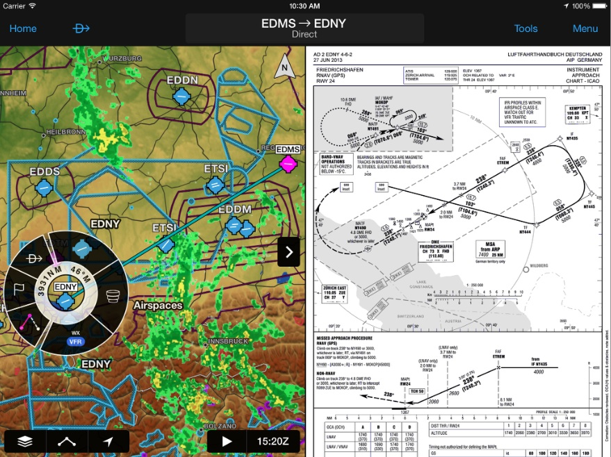
Navigation
Garmin Pilot reduces the amount of paper charts needed to complete a flight, offering pilots electronic flight bag capabilities around the globe. Configurable maps give pilots the option to customize the display of charts, weather overlays, terrain and obstacles in split screen view so a variety of information can be displayed simultaneously. Visual Reporting Points (VRPs), commonly found in Europe are overlaid on the moving map page, allowing pilots to easily report their position. Global terrain, as well as U.S. and Europe obstacle alerting available within Garmin Pilot, offers an enhanced level of awareness in even the most challenging terrain environments.
Additional New Features
For an additional fee, customers will also have access to geo-referenced European FliteCharts (terminal procedures) for select countries. Garmin Pilot optionally supports European VFR and IFR charts with VFR data sourced directly from Deutsche Flugsicherung (DFS) and IFR charts from Eurocontrol.
SafeTaxi allows pilots to easily navigate unfamiliar airports and conveniently displays geo-referenced airport diagrams throughout portions of Europe directly on the moving map. With this update, FliteCharts and SafeTaxi coverage is further extended into Canada and includes approaches, departures and arrival procedures.
Another new feature with this update is Smart Airspace, designed to make it easy to identify what airspace lies ahead. Smart Airspace highlights the airspace nearest the aircraft’s current altitude and de-emphasizes non-pertinent airspace so pilots can quickly identify their location relative to the airspace around them. Additionally, the altitude filter removes airspace above the user-defined altitude.
One of the cooler new features with this update is FastFind, which incorporates predictive logic to suggest airports and waypoints using current GPS location, making quick flight plan entry possible. FastFind automatically begins searching for the nearest identifier as an airport or waypoint is entered within the flight plan.
Download
Garmin Pilot 6.2 is available immediately as a free update for existing customers. For new customers, Garmin Pilot is available in the Apple App Store as a free download for the first 30 days. After the 30-day trial period, customers may purchase an annual subscription of Garmin Pilot featuring worldwide coverage starting at $199.99.
Pilots may purchase optional FliteCharts, SafeTaxi, DFS and IFR charts starting at $49.99. Garmin Pilot Canada Premium includes Garmin FliteCharts and SafeTaxi diagrams for Canada, text-based weather products, as well as radar and satellite imagery for the U.S. and Canada and is expected to become available in August for $149.99. Visit the Apple App store to download Garmin Pilot and visit www.garmin.com/aviation for additional information.
