Sunday, March 18, 2012

TomTom Launches Dedicated Page for US National Park Maps

94779

Next to driving directions, outdoor activities like hiking are where GPS devices get the most use. Although any experienced outdoors enthusiast will tell you that a paper map is a must-have when exploring, a GPS device can be great for finding your way to and from camp and exploring different trails in the area.

Recently, TomTom launched a new page dedicated to helping GPS users more easily find trail maps for popular US National Parks in several states. The maps are available for free download, and are compatible with any device that can read GPX files. Although TomTom has been pushing using its TomTom Spark and TomTom Adventurer watches with the files, devices like the Garmin Edge series should work too. read more

Exhibition at the British Library Delves Into Mapping History

800px-world_map_1689

From the first hand drawn maps used by explorers and sailors to the digital maps used by your average college student navigating a new city, maps are an important part of the history of not only humans, but travel and even GPS. After all, without accurate maps, GPS signals would be basically useless—as seen by the vast number of people who ended up lost because the GPS tried to direct them through streets that no longer existed.

Now through March 1, 2017, the PACCAR Gallery inside the British Library in London will be hosting an exhibition of paper maps. Called Maps and the 20th Century: Drawing the Line, the exhibition explores the power and evolution of maps across the last century and questions how maps effect our daily lives and what it means to be mapped. read more

TomTom Expands Global Maps

tomtom-logo_1

Dutch company TomTom has almost undoubtedly one of the biggest mapping footprints, and the company is constantly expanding and adding new points and details to its global maps. Most recently, TomTom announced that it has added an additional 13 countries, expanded points of interest and made other improvements.

Here are some of the improvements that TomTom has made recently: read more

GPS and Map-Reading Skills

Street Photography in NYC

I came across a really interesting article published by the BBC earlier this month regarding the use of sat-navs and GPS navigation and how the proliferation of these technologies is a threat to basic map-reading skills. The article itself talked a lot about how the younger generation doesn’t know how to read basic maps and is, therefore, losing a lot of basic skills and independence.

“Many cannot read a landscape, an ordnance survey map, or find their way to a destination with just a compass, let alone wonder at the amazing role astronomy plays in establishing a precise location,”  the president of the Royal Institute of Navigation (RIN), Roger McKinlay told BBC in the article. “Instead, generations are now growing up utterly dependent on signals and software to find their way around.”

But, is that really a problem? read more

TomTom Expands Maps to Australia

tomtom-logo_1

TomTom, the Dutch-based mapping and navigational company recently announced that it has acquired Location Navigation including the WhereIs map assets and customers from Sensis. With this acquisition, TomTom will be able to both improve and expand its mapping into Australia.

Currently, TomTom already offers maps for Australia, New Zealand and Asia. However, the addition of these maps will help improve TomTom’s reach and allow it to release real-time mapping and other features to these countries. read more

Strava Heatmap Shows Popular Routes

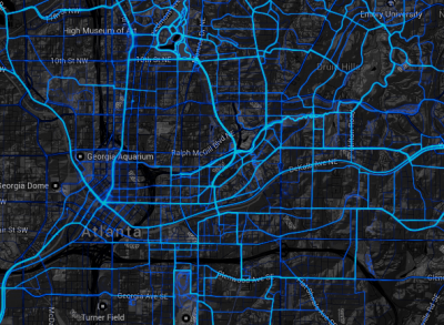
atlantaheatmapstrava

If you are one of those people who enjoys a daily run or bike ride, then it can sometimes be easy to get caught in a rut and simply take the same path you always do. After all, it can be hard to find good trails and routes sometimes, and it can be tempting to just stick with what you already know.

Well, the popular fitness tracking company Strava recently introduced a new interactive map that is designed to help you explore new trails and areas and find popular routes you might not otherwise know about. Called the Strava Heatmap, this pretty nifty-looking interactive map uses GPS track data from around 160 million rides and runs to determine the most popular areas.

It looks pretty cool too. read more

TomTom Crowdsourced Maps Raise Concerns

tomtom-logo_1

Late in January, TomTom announced innovation that would allow it to collect user location data and analyze it in order to provide maps that would be updated for accuracy daily. However, with all of the recent privacy issues around the world, many people have begun to express concern about exactly what TomTom is going to be doing with this sensitive information. read more

TomTom Improves Worldwide Maps

tomtom-logo_1

TomTom is one of the leading mapmaking companies in the world, and its database covers more than 44 million kilometers of road and around 4.2 billion people–more than half of the world’s population. TomTom has fully navigable maps for around 126 countries, with more added every year.

Late last week, TomTom announced that it will be updating several maps around the world including pedestrian maps for several cities and more address points in Europe. The updates should be available soon. Here are the updates TomTom has released: read more

TomTom Crowdsources Map Changes

tomtom-logo_1

As far as navigation goes, the only thing that smartphones do better than more traditional GPS units is mapping. Which, of course, is actually pretty important. Most cell phone mapping programs update twice as frequently as dedicated units do and since navigation is really only as good as the map its based on, it was something of a boon to smartphone app makers. Note the past tense

TomTom, one of the three biggest mapping and navigation juggernauts in the world, announced yesterday that they, too, are going to have maps that update faster and flag changing conditions. And, just like a lot of smartphone app developers, they’re going to do it via crowdsourcing.  In a press release, TomTom introduced their new Map Input Tracker API. This feedback tool can be integrated into existing product lines and will allow customers to share map feedback via their smartphone, tablet, laptop or even in-dash navigation. read more

TomTom Map Updates to Come Sooner Than Ever

tomtom-logo_1

Last week, TomTom announced the release of their new MultiNet-R map format, which will feature real-time maps with incremental updates. Starting in 2014, updates are expected to be completed monthly instead of yearly. TomTom further promised weekly map updates starting in 2016. Sounds like quite a lofty goal, and if they manage to pull it off, it will be a heck of a boon for TomTom. read more