Sunday, March 18, 2012

Pinit App Combines GPS With Social Media


logo present

There is something about photos of vacations that just stirs the mind and always brings a smile to my face with each captured memory. While there are plenty of ways to share these moments with friends and family, most traditional social media is so cluttered with junk—be it videos of cats, quizzes, games or other distractions—that such important moments tend to get lost. However, UK teen Tyler Ball is looking to change the way that people share their travels and photos with his new app Pinit.

Created to act almost like a digital travel diary, Pinit allows users to geotag photos and place a ‘pin’ on a location connected to a photo or status, and a memory. Over time, users can create their own world maps with pins showing all of the places they have visited. Friends and families can follow each other and comment an even ‘like’ photos and statuses. read more


GPS App Helps Those in Need

donafy

Smartphones aren’t just for Instagram and bird-related games. A smartphone app creator in Philadelphia wants to encourage you to use your device for micro-philanthropy to help the needy. And, all it requires is the push of a button.

This week, the app Donafy–a play on the words ‘donate’ and ‘notify’–debuts on iTunes for the Philly area. Created by a tax attorney in the city who wanted to give people an easier way to help the needy and those on the street, Donafy is meant to make doing your part to help as simple as pressing a button. read more

App Provides Navigation Inside Stores

gpsindoor

Imagine it: you walk into the store with a short grocery list in mind. You input the items in your phone and an app immediately maps out the most efficient route to each item on your list. You follow the flashing blue dot from one item to the next, and the phone vibrates on occasion, alerting you to coupons and advertisements for relevant products as you walk past. This might be the indoor GPS of the future, and it’s available now. read more

New GPS/Nav App Provides 3D Views

iphone-en

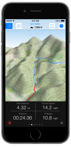
If you’re looking for off-road navigation then you probably have a dedicated GPS device that you use instead of a smartphone. Even with off-network capability, these apps aren’t incredibly helpful most of the time when you’re backpacking in the middle of nowhere, or trying to find your way through a rural area. And, while I’ll never try and sell you that smartphones are better than GPS (they aren’t) if you have an iPhone, this new app might be something worth looking into.

Maps 3D Pro costs about $5 on iTunes, and is actually designed for hikers, cyclists, skiers and outdoor enthusiasts. Not only does it give you terrain and altitude details and download to your phone, but you can actually select what kind of map you want based on where you’re going. Maps 3D Pro draws maps from NASA satellite views, 3D topographic maps, Open Street Maps (for city navigation) and USGS maps just to name a few. You can look at the maps in regular 2D or in beautifully rendered 3D, depending on your needs. You can even zoom and rotate around the 3D version–sort of like a Google Earth for your phone. If nothing else, it’s kind of pretty to play with. read more

GPS & Augmented Reality Show Berlin Wall History

time traveler AR

Through augmented reality, you can see what Berlin was like when the Berlin Wall was built.

There is nothing I enjoy more than seeing GPS used in unusual and creative ways. Recently, a German company has created a TimeTraveler app that allows visitors to learn about the Berlin Wall through GPS-based augmented reality. Available on both iPhone and Android devices, this cool app lets your phone act like a window to the past. read more

Bike+ App Does More Than GPS

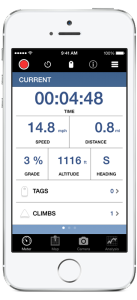
BikePlusAppImage1 A bike ride isn’t just GPS and ride statistics like distance, duration and elevation—a bike ride is about an experience. Most cycling apps and devices are so busy with the statistical data that they don’t leave time to capture the actual experience of the ride. So, world champion bikers James Mathis and Ted Huang created their own app to do just that. read more

Can You Use GPS to Avoid the Flu?

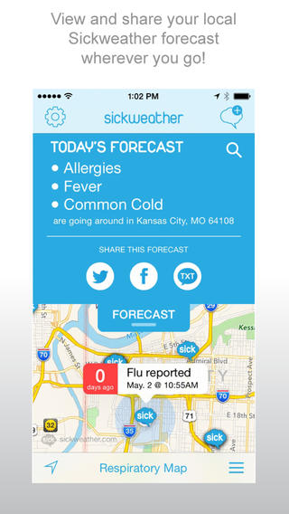
sickweather screenshotThere are all kinds of apps for your smartphone that are designed to use GPS to help improve our lives. Some of them are incredibly useful, and others…well, they are mostly just odd. Joining the ranks of odd (and slightly creepy) apps is the app Sickweather.

The idea behind Sickweather is to map out places where people are sick by scanning social media like Facebook and Twitter for people posting they aren’t feeling well, and then using GPS to see where they are. The app then puts it on a map so you can see where the sick reports are and follow trends of illnesses. That’s the idea, anyway. And while the theory sounds kind of useful, when you stop and think about it… well, it isn’t. read more

Hiking App Helps Locate Most Beautiful Spots

Stand Here

Stand Here photo

As you reach the top of the hill, you see the sun turn the leaves of the trees to tiny emeralds. The filtered light illuminates the cool waterfall ahead with the magnificent warm-colored stones worn smooth from the water and for a moment, your breath catches as you gaze at this perfect spot. There is nothing quite like the natural beauty of the wilderness, and such sights are the reason and reward for many hikers who explore the wild areas of the world. While sometimes the best views are found by accident, others are not.

Introducing the Stand Here app, a hiking companion app designed to help hikers find and protect the most fantastic spots in the world. Available only on iTunes, the app is free and includes a number of functions to help hikers find their ways to the most wondrous spots in the U.S. and track their way safely back. Created by acclaimed photographer Rodney Lough Jr., the app has been about six years in the making  and was released on August 8, 2014.

“The goal is to identify beautiful places, help educate people on why they are special and get people to stop and stand there. To have that moment of awe that takes your breath away,” Lough said. “Then we can understand why we need to protect these places.”

read more

Use GPS To Unlock Secret Messages

TracesIn the digital age, it seems like people have become more and more detached from each other as social media and messaging becomes more and more common. A new app, called Traces, is trying to change that with an immersive messaging system that uses GPS location and augmented reality to force users to get out of the computer chair and go and find messages from friends. Half treasure hunt, half phone messenger, Traces is a really unique and awesome use of GPS technology that I just had to share.

“Facebook and WhatsApp broadcast frequent, out-of-context information that’s of very little value to you, leaving you a completely passive receiver,” said Beau Lotto, CEO of Ripple Inc, based in San Francisco, which created Traces. “Instead of reading tweets in a random location you can choose the location to add context to your delivery,” Lotto said. read more

Endomondo App Syncs with Pebble Watches

ENDOMONDO LOGO

Endomondo, the popular social fitness network, has introduced a new smartphone app that syncs with Pebble and helps users meet their fitness goals. This free app from Endomondo allows users to start, pause or stop a workout while exercising and can display up to three configurable data metrics, such as distance traveled, heart rate and workout duration – making it one of the most advanced fitness tracking apps for Pebble.  Additionally, the app vibrates Pebble smartwatches for each mile or kilometer completed, and will briefly display a performance summary. read more