Whether you’re walking, hiking, cycling, or driving, GPS directions are incredibly useful for finding your way around. However, as anyone who has ever used a GPS knows, it is far from 100% accurate, although directions are getting better and better each year. One thing that hasn’t seemed to see a lot of improvement, however, is pedestrian directions.
Sure, there are plenty of GPS devices which claim to offer pedestrian-specific directions, and even Google Maps has this functionality… but it’s far from perfect and many times things like curb cuts, sidewalk interruptions, and ramps are often not taken into account. However, a Seattle-based company is looking to change that with the new program AccessMaps.
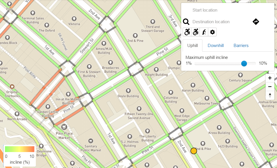
With AccessMaps, pedestrians can chart routes through the city streets and view important accessibility information such as steepness, presence of curb ramps, crossing points, and even roadwork and construction. The map is only available in Seattle at the moment, but it is expected to expand into multiple other cities in the future. The team has designated the following ten cities as possible candidates: New York, Boston, Chicago, Portland, Pittsburgh, San Francisco, Denver, Philadelphia, Washington D.C., and Atlanta.
The mapping application, which is currently only available online, uses street information from OpenStreetMaps for the basic layout of the city. However, the sidewalk information is collected through a project called OpenSidewalks. The project was launched by AccessMaps and is similar to OpenStreetMaps. The project crowdsources pedestrian route information in real time and allows users to report on things like construction blocks, handrail access, ramps, and available lighting.
Information that can be selected when charting a destination include hill grade, condition of the sidewalk, presence of ramps, and routing around construction hazards. Users can also select their mobility level as well in order for the map to create the best route. The map automatically takes things like street crossings into account when routing. Eventually, the creators intend to include additional features, but it is still in progress.
AccessMap is, of course, free for use, although users can donate if they wish to support the developers. You can take a peek at the options and map out a route on the AccessMap site.
it’s pretty nice