
GPS for hiking!
When selecting a GPS for hiking, two key criteria come to mind. It’s likely that a hiker will want a unit that’s good for navigation and that will not encounter reception problems.
Reception is important
So for one thing, I’m limiting my recommendations to high-sensitivity receivers, such as those with the SiRFstar III or MediaTek chipsets. With these receivers, you can stick them in your pocket, or a mesh pocket on a day pack, and you are still likely to have adequate reception. Some of this is dependent upon how the satellite constellation is positioned relative to your location on any given day, but overall, I think you’ll be happy with the performance of these units.
Navigation and maps
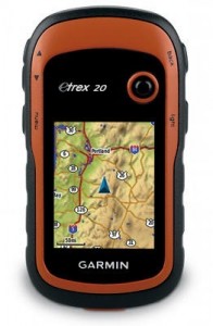
Garmin eTrex 20
The other important thing is getting a receiver that is set up to navigate. Not all GPS receivers can accommodate topo maps. If you’re content with a receiver that won’t let you add detailed maps, check out the Garmin eTrex 10. Otherwise, stick with a mapping unit. Be aware though — most units don’t include detailed maps. Fortunately, there are plenty of free (and legal) topo maps for Garmin units. One other note before we get into the recommendations — you may also find it helpful to check out my Garmin handheld GPS comparison chart.
Budget GPS for hiking
Our choice: Garmin eTrex 20
- Bright color screen
- Can accept detailed topo maps
- Tons of features not previously available on entry level models; if you can swing the price, this is the one to get
Other budget units:
- The Garmin eTrex Venture HC can be significantly cheaper but carries an older, more complex interface, and lacks paperless geocaching and a few other features
- The Garmin eTrex 10 is a new model that has a monochrome screen; you also lose the ability to load maps. The eTrex 10 is available for just under $100 at the time of this update.
Mid-range GPS for hiking
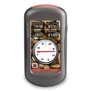
Garmin Oregon 450
Our choice: Garmin Oregon 450
- Touchscreen
- Barometric altimeter and tri-axial electronic compass
- BirdsEye aerial imagery capability
- Garmin custom maps capability
- Advanced track navigation
- This unit has recently been on sale for as low as $185
Alternative mid-range unit:
- The Garmin Dakota 20 is a smaller version of the Oregon. Once its been on the market for awhile, it should start to show up at a discounted and very attractive price.
The top of the line GPS for hikers
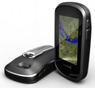
Garmin Oregon 600 series
There are several units to consider here; all have a barometric altimeter and tri-axial electronic compass.
- Garmin Oregon 600 or 650 – The latest and greatest from Garmin, these units offer a capacitive touchscreen and a huge array of customization options. The 650 adds an 8MP geotagging camera.
- Garmin GPSMAP 62s – Perfect for those who don’t want a touch screen unit. It brings all the latest features such as paperless geocaching, BirdsEye aerial imagery, custom maps and advanced track navigation. Step to the 62st for pre-loaded 1:100,000 scale topo maps of the entire US.
- Garmin Montana series – I reviewed the Garmin Montana 600 and have been very impressed with it. Yes, it’s a bit on the big side, but that really didn’t both me much. And it’s the best dual-use unit Garmin has ever offered.
Other high end units:
- Another option is to get a couple of Rino 650 units for you and your outdoor adventure partner. That way, you get most of the advantages of the 62s, plus you can see their position on your screen (and vice versa)!
Related posts


There are many hand-held GPS which do what you want. I have a Garmin Etrex vista HCx which will do all that, but it isn’t the only one. Downloading maps from the computer and marking position is standard.
Just wondering. are all of the units able to display UTM or customary coordinates? A unit that only displays Latitude and Longitude is fine for geocashers, but hikers need to be able to locate themselves on topographic maps. Which usually use localised datums and mapping grids. Perhaps it would be good to cover this.
Except for the simplest handhelds, just about any will display UTM. If you have a particular model in mind, let me know and I’ll try to verify it for you.
Thankyou,
After the comment, I found an online user manual for the Garmin Etrek 20. I did find the option to change the datum. Locally here in Australia we use the MGA coordinate system – which is for our purposes the same as UTM. Some of the older maps use AMG, and this can be a source of confusion. But displaying UTM would be fantastic! Thanks.
You can indeed display UTM on the eTrex 20.
I want to get a handheld gps but overwhelmed that there’s a device for hiking, biking, golf. I currently have a Garmin in my car. Is there a model out there that does it all? I’m also shopping around for a fish finder
If you buy a unit that does it all, you will be paying for things that you don’t need. Work out what you need and what you will use it for, then someone might be able to make a recommendation, and maybe help you with your selection.
It would depend upon what your uses are, but the best all around dual purpose unit (handheld + driving) is the Garmin Montana series. But it’s pricey, especially after adding City Navigator maps and a mount.
Its about time Garmin put out a new Oregon GPS. The 550 is nearly 3 years old now.
Good point. I’m expecting new handheld announcements from Garmin around late May to early June.
Recommendation please:
Sorry, forgot to tell you what I wanted to ask. Recommendation:
I want to buy a handheld to take with me to Mexico, Costa Maya, on a long range fishing trip. I’m taking my kayak and will be gone about a month exploring the bays and complex lagoons. I’m assuming there are no maps for this area. I simply need something that will bread crumb my route so I can get back to my car. Also, aerial view is important. It appears Garmin is what you like, what about the Lowrance models? Mid to high range is what I’m looking for, but something very reliable because well… I guess no explanation needed. Thank you.
I’d stay away from Lowrance. Garmin does have marine charts available (example- https://buy.garmin.com/shop/shop.do?pID=33574&pvID=34887), but I suspect that BirdsEye aerial imagery may work better for you, so I would definitely suggest a unit that has that capability. I’d look at the GPSMAP 78s (it floats) or the Montana 600 (big screen)…
http://gpstracklog.com/2010/06/garmin-gpsmap-78s-review.html
http://gpstracklog.com/2011/08/garmin-montana-600-review.html
http://gpstracklog.com/2011/07/garmin-birdseye-satellite-imagery-2.html
Perfect, I was looking for something waterproof but had trouble sifting through all the different models. I looked at the marine maps, for $160 it seems a little over the top for a kayak trip in mostly shallow water, bays and lagoons. Sounds like I could get by just using Birdseye.
I like to Disc Golf all over the US. But I find the the signs are not very accurate about the distances and would like to map out a course to get better distances and elevations. I have tried using my NUVI 500, but it seems to be lacking in the resolution needed for measuring a course. Ideally it would be nice to just turn the GPS unit on at the start of round and turn it off at the end of the round. Then off to the computer to download and edit in something like basecamp or google earth. I would know where the tees and baskets are by time spent at one location or move the GPS unit prependicular to my path at the front of the tee box and over the basket. I know this is too much, but the closer to this the better.
I assume you have the nuvi in off-road mode. It’s probably not as accurate as handhelds though.
A basic handheld like the eTrex 10 would work fine, although the eTrex 20 would add a color screen, the ability to load maps and aerial imagery. I’d encourage you to set a waypoint at each tee and basket. There’s also a waypoint averaging function to get better accuracy when establishing a waypoint. Also, be aware that GPS satellites aren’t geosynchronous so there are good days and bad in terms of accuracy. There are some predictive calculators online if this is important to you and you have that flexibility.
Thank you for the reply. Yes I did have the NUVI in off-road mode.
My latest try at using the NUVI involved adding waypoints as you suggested, but that did not work very well. The NUVI does not have a “vehicle” for selecting point on the map, so most of the waypoints ended up off the trace route that the NUVI generates and puts in log files.
I will be checking into the predictive calculators
You may already be doing this, but can’t you tap on the map at your current position to set a waypoint?
When creating a route with the NUVI 500, the first action is to tap add a new end point, then you have access to all features of the NUVI for picking that point. When you go the map to pick your current position the cursor is centered on the last point it knew about before starting to create the route. The “vehicle” is visible at your current location, but tapping does pick it. Instead the cursor moves to where ever you tap and my fingers are way to big to be very accurate. Plus you do not know exactly where on the “vehicle” is the current location. I also had to zoom in seven times to get to a scale of 120 feet. I probably should have zoomed in to the minimum, which is 20 feet and five more taps (UGH). Even then the “vehicle” still covers on the order of 4 sqft.
Maybe I should not have been trying to create the route on the NUVI, but in basecamp after the fact. Then the process would have been one of adding favorites, which does select the current position when you tap on the “vehicle” on the map. But then I will have 36 favorites to delete from the NUVI after I am sure basecamp collected the points properly.
Is there any of the hiking oriented GPS which will record your path, and link that data to pictures you take based on time-of-picture?
Just about any handheld GPS will record a tracklog, which has timestamps. This can be used to geotag photos. All the units list above can do this, but you’ll need to use some software to add the coordinates to the EXIF data.
There are also GPS units with built-in cameras that do this (and cameras with built-in GPS too).
Hi Rich. Do you have any recommendations for software to link GPS date and photos. I have looked at TopoFusion but the maps of Europe are not very useful. Is there anything else?
I don’t, but I did a couple of Google searches that look promising, using the following search terms:
geotagging software
geotagging on google earth
I am a novice to GPS selection. I am looking for a GPS which does the following
1. Accurate and reliable GPS connection
2. Be able to load topo maps
3. Generate a trip map, with distance + time + elevation
Appreciate if you can provide any links to sites with free topo maps for hiking.
Thanks in Advance.
1. Any of the units above
2. Any of the units above except the eTrex 10
3. I’m not sure what you mean here. But note that GPS isn’t as good for determining elevation, though in many situations a unit with a barometric altimeter will improve this.
Free maps for Garmin units: http://gpsfiledepot.com
I also suggest reading this series:
http://gpstracklog.com/category/handheld-sport-gps/handheld-gps-101
Feel free to follow up with more questions.
Hoping to get some advice on choosing between the etrex 20 and oregon 450. Trying to decide if the extra money is worth it to jump to the 450. It will be used for hiking in various terrain and cover. I don’t geocache. One question I have is how accurate is the electronic compass?
Thanks for any advice!
Pretty darned accurate, IF you calibrate it.
It’s a tough call. I’d go for the 62s over either, but its more expensive.
The eTrex seems to have a slower processor, but has GPS+GLONASS, a brighter screen and great battery life.
The Oregon is better for text entry and has a bigger screen, plus the barometric altimeter.
Thanks for the info. I wonder how handy is the barometric altimeter? How often much does a guy use it and for what purpose aside from determining elevation?
Unless you want to track weather changes, that’s it. GPS is much less accurate for elevation than lat/long, hence the use of barometric altimeters. These can improve elevation data unless a front is moving through. I like having them on my devices, but some people find the varied accuracy frustrating.
On units that have the barometric altimeter, do you have a choice as to which to use? Is averaging with GPS altitude done?
Elevations are used in disc golf to determine the effective length to a basket. The guideline used is for every 10 feet of elevation change the distance is changed in the same direction by 30 feet. This is a significant change.
You can change them to use “fixed elevation,” which disables the barometric altimeter. But it sounds like you’re wanting more accurate elevation data than a handheld GPS may be able to provide.
We want to use a gps handheld tracking device in the Ranomafana National Park in SE Madagascar. I tried reading a bunch of sites, but not found a specific or direct answer to what device would work best there. I think something works there (or nearby) because of an article about a Bronx Zoo researcher geotagging her photos.
I see above that you tell us that the eTrek uses GPS+the Russian GLONASS networks. I think in the long run the European Galileo will provide more complete coverage of Madagascar and work together with our GPS. But I do not know what actually works there now in 2012.
I am hoping that you can tell us more. Thanks.
And another question beyond coverage and reception sensitivity:
Maps is of course another issue. The only topographic maps I have found so far for Madagascar are of Russian or French origin. They are available at http://www.omnimap.com/catalog/int/madagasc.htm#p1
There they are selling a full set, but once I am sure I can flexibly use such map types, I will find the couple that cover the area where we will travel. So what handheld gps devices are best for loading random maps? This device will be used largely outside the lower 48 US states. So in the long run, maps for Peru and Chile, maps for China, Burma, Thailand and Laos. We will need sources and the ability to load the maps found. This should paint a clear picture.
You just need a recent model GPS which should have a high-sensitivity chipset.
Generally speaking, Garmin units are best for international map availability. The maps you referenced would need to be scanned and converted. The latter can be done using Garmin custom maps, but the results may not be ideal and the process has significant limitations. Here are some articles on the subject…
http://gpstracklog.com/tag/garmin-custom-maps
Unfortunately, that may be your best bet for topo maps. For street maps there are paid versions…
http://www.garmap.com/Catalog/List.aspx
and free ones…
http://downloads.cloudmade.com/africa/eastern_africa/madagascar#downloads_breadcrumbs
Hi, first off I would like to thank you for such a great and informative website. Am considering the purchase of my first gps unit and so have been browsing through your site for the past hour…
I would be very grateful if you could tell me if the “intergrated outdoor calendar” feature of the Garmin GPSMAP 60CSx can be found in any other device? Basically what I am looking for is a device where I can put maps/routes and will tell me my position. So the most basic features. In addition, I would love something which tells me the direction and times of the sunset/sunrise (as I love taking photos…). It seems the outdoor calendar does this for the moon? Do you know of anything else which would do this for the sun? I have software on my computer but it requires internet access.
Thanks in advance
M
Most Garmin handhelds have both Calendar and Sun and Moon features, showing sunrise and sunset times. I would shy away from the 60CSx and go with a newer unit though, like the eTrex 20/30, Oregon 450 or GPSMAP 62s.
Hi
thanks for your reply. What I am looking for though is times as well as the direction (angle). Of course for one-off hikes one can look it up beforehand but I am planning on traveling for an extended period in different locations (countries/continents) with irregular internet access. I have looked into it and it seems the Garmins only provide the times?
This is what I have for my computer:
http://photoephemeris.com/
Anything at all similar in GPS? Or at least times and angles…
Thanks for your help
M
I am interested in a unit that tracks our hike so that my family at home can follow us. We plan to trek Nepal. We will have guides, but my elderly parents would be interested in following our whereabouts on a daily basis on their computer. What do you recommend?.
This is perhaps the best, most reasonably priced option right now. It can be used as a standalone unit without a smartphone.
Oops, left out the link…
http://gpstracklog.com/2012/02/delorme-inreach-for-android-review.html
I travel in remote locations in Turkey. Are there maps I can download for Turkey?
I found this…
http://mapcenter.cgpsmapper.com/maplist.php?cnt=217&rgn=&cat=4
Interestingly enough, it looks like there used to a be a Garmin topo product for Turkey, but I don’t see it currently available from any legitimate sources.
Thank you Rich. I travel in Turkey every year to research ancient cities and increasingly, I’m getting into more and more remote areas. I’ve never gotten lost, but I am planning to purchase the Garmin eTrex20 for this Summer. I’ve never had a GPS unit before. The only map I see on Garmin’s website is the “BirdsEye Satellite Imagery”. How good is this? What kind of detail can I expect? I don’t see anything for Turkey anywhere else.
I suspect you will be looking at 15-30 meter resolution. It *may* be similar to what you can see in Google Earth.
I am relatively new to GPS, working with local trail and canoeing groups, and am looking for a unit to use hiking, biking and canoeing to create as accurate as possible maps (i.e. transfer to my computer) of campsites, parking areas, trail features, launch sites, river hazards, etc. Waterproof, easy to use, rugged, accurate, etc. Looking for suggestions and advice.
Any of the mid- to upper-end options will work. A touch screen unit like the Oregon is easiest to use for naming waypoints, but slower in terms of accessing other functions. The Montana series brings the advantages of a touchscreen but gives fast access to other features too. The GPSMAP 78s is a good choice for canoeing, since it floats. That or the Montana 600 would be my high-end choice. Mid-range, I’d go with the GPSMAP 62s or eTrex 30. My budget choice would be the eTrex 20. Hope this helps.
Heading out to Colorado and will be hiking in the Flat Tops area. I’m trying to understand how much additional help the eTrex20 will be over the Venture HC. I have not been wilderness hiking in a long time (pre-GPS days). I am map and compass capable, but I would love to have a GPS unit helping me navigate trails, if possible. Any quick education would be much appreciated.
All these features are found on the eTrex 20 but not on the Venture HC:
http://gpstracklog.com/2011/04/five-reasons-to-upgrade-your-garmin-handheld.html
Thanks for this excellent site Rich.
I’m planning to get a GPS for trekking in Singapore and Canada. I see topo maps for Canada but none for Singapore on the Garmin website. Would any free topo map be as effective on the eTrex 20 or is the Birdseye Satellite Imagery enough for this?
I doubt that BirdsEye imagery will do much good unless you’re in very open terrain. This site covers the region pretty well and says they have topo maps in their downloads area (registration required)…
http://www.malsingmaps.com/portal/downloads.php
Mr. Owings,
First and foremost, thank you so much for putting this site together and taking your time to answer questions.
I work part time in Romania. I do a lot of hiking in the states, Canada, and in Romania. I would like to do some more exploring in Romania, but I do not want to get lost as it can be dangerous.
I need a GPS unit, around the 300 dollar range as a maximum that does the following: I need to be able to load worldwide maps including Romania. I would like the unit to be able to hold these without putting in a bunch of interchangeable sd cards. I need it to be relatively accurate and always have a signal. I would also like to be able to use it on regular roads in a car mount. Geocaching is not important to me. I have been trying to find a unit like this by navigating your site, but there is so much information I thought it might be better to just ask.
Thank you very much.
Dominick Chase
First of all, I would suggest a Garmin, since you’ll find more international maps available for them than with other brands. Even so, finding Romanian topos will be difficult. There are these…
http://mapcenter.cgpsmapper.com/maplist.php?cnt=184&rgn=&cat=4
and this (although I don’t see any indication that they include topos)…
http://www.garmin.com/us/maps/third_party_mapsource_developers#Romania
You can also scan and load topos to the newest Garmin handhelds using their custom maps functionality.
If you want to use your handheld as an auto unit, you’ll probably also want to buy routable maps, a charger and a mount.
We live in the states, but we’ll be crossing England on Wainwright’s walk in 3weeks: 200 miles over 14 days. We are booked on a self-guided SherpaTour from inn to inn and have well-done Trailblazer Guide book with accompanying excellent topos, however, there are several areas in Lakes District where guidebook indicates poor trail markings and potential problems in very low visibility. Guidebook includes downloadable .gpx file for Trailblazer waypoints established on Ordinance Survey grid used in UK. If we are caught out and had GPS configured with Trailblazer .gpx file we could establish a fix on present position, pick relevant waypoint, then “go to” that piont, and we would have solid info about direction to head in order to stay on guidebook trail. Have 40+ years of hiking in NH, VT, ME, NY, CO, CA, but never used GPS. Can you recommend a good waterproof unit to purchase and configure before we go that would be turned only as needed to operate in UK’s OS grid system and could upload Trailblazer .gpx file waypoints? Thanks, DRC
Most handhelds will allow you to show the British Grid, but the .gpx files should work regardless of that setting. In other words, you should be able to use lat/long or UTM display and still have it direct you to the waypoints.
One of the newer units, such as the eTrex 20, will allow you to add OS maps…
http://gpstracklog.com/2012/05/european-topo-maps-for-garmin-handhelds.html
Handheld GPS can be a bit complex. This series is designed to help…
http://gpstracklog.com/category/handheld-sport-gps/handheld-gps-101
Any GPS unit will do what you want. I’ll leave recommendations to others, though I think it should be one with onboard maps (which you will also need to buy). As for use in Britain, you will need to go into the configuration and change the grid to OS grid (or something similar. (OS stands for Ordnance survey). OS maps all have this grid marked on them so you will be able to see where you are easy enough.
Whilst it is true that you can use a GPS as you suggest, you can make it much more useful. Since you will have imported the .gpx trail you can follow it (track or trackback) all the time – this will give you instructions on which direction to head every 20 yards or so. Equally if you buy GPS software for your computer and import the .gpx trail you will be able to view the trail on Google Earth before setting out.
Don’t come to think of the GPS as infallible, though; 40 years of mapreading will still be a useful asset.
I’ve written up some ideas on using a GPS at http://www.pyreneanway.com/blog/2011/08/how-to-use-a-gps-for-walking/?lang=en
My wife and I will be hiking the Haute Route (Chamonix to Zermatt) in a couple of weeks, and need GPS guidance in case of white-outs). I currently own a Garmin Foretrex 401, which appears to be useless for my purpose, since it cannot import maps, so I’m considering one of the more capable units, like the eTrex 20 or one of the Oregon models.
Before purchasing the Garmin, I wanted to see what the maps look like, so I installed BaseCamp on my Mac, and I downloaded map files from a recommended site, kowama.de. There I found two download options: one which included a single very large .img file, and the other with a lot of smaller files. I downloaded both, and I assume that the large file is a single map of the entire Switzerland, and the others are maps of smaller regions.
Anyway, my problem is that I can’t figure out how to load (import?) the maps into BaseCamp. BaseCamp does not seem to recognize the .img file format as something it can import. My understanding is that I should import the maps to BaseCamp, and then connect a new Garmin GPS to BaseCamp and transfer the maps into the GPS. Do I have that backwards?
I want to be able to use BaseCamp to draw out the actual planned routes, and ask the GPS to guide us on those routes (rather than telling us the crow-fly direction to the next waypoint).
I’m totally new at GPS guidance, so I may be missing how things work.
thanks for any help anyone can provide.
You’ll need MapInstall for your Mac. More info here:
http://gpsfiledepot.com/tutorials/how-to-load-maps-on-my-garmin-gps-unit/#mac
I also recommend reading this:
http://gpstracklog.com/2012/05/european-topo-maps-for-garmin-handhelds.html
and this series:
http://gpstracklog.com/category/handheld-sport-gps/handheld-gps-101
OK. Thanks. I’ve read through any of your posts, and I now understand a lot more. But my main question is still unanswered:
MapInstall allows me to load a map into my GPS, but how do I import the map (.img file) into BaseCamp?
Related question: Once I have a map loaded into BaseCamp, or other mapping software (e.g., TopoFusion on PC), is it possible to combine a .gpx track with the map, so that the track shows on the map?
thanks,
Irv
Sorry. Map Install includes Map Manager. You may need to reopen the downloaded file and it also depends upon how Mac install friendly the developer made the map. What is the map? Can you provide a link?
Yes, you can display .gpx files on the map, using BaseCamp, TopoFusion, etc.
Thanks. OK. I’ll try that when I get home tonight.
Here is the link for the topo maps of
http://www.kowoma.de/gps/freieKarten/osmkowomafreizeitkarte.html
The site is in German, but the first two links found after the example map image are the ones for Switzerland. They indicate that the first link is for map(s) to upload into a Garmin GPS, and the second link is for map(s) to install in BaseCamp.
If I can make all this work, my next quest will be to find a link for downloading recorded tracks (gpx files ?) for the hiker’s Haute Route from Chamonix to Zermatt.
Then, I’ll see if I can paste the tracks onto the topo map.
Can I do all this and use the eTrex 20 ? or do I need to spend for the Oregon 450?
Thanks,
Irv
Nice looking maps! Yes, you can do all this with an eTrex 20, although it doesn’t have the Oregon 450’s barometric altimeter and electronic compass.
OK. I opened MapManager separately, but it also does not recognize the .img map files. (I think these are disc images?)
This is the site others have used to get map files for Garmin GPS units:
http://www.kowoma.de/gps/freieKarten/osmkowomafreizeitkarte.html
Perhaps I can only load the maps directly into a Garmin? or Perhaps the PC version of BaseCamp would be more flexible?
thanks,
Irv
The map files may be set up for PC installation, so yes, I would try that if you have access to a Windows machine. If that doesn’t work, here’s the next thing to try…
http://gpsfiledepot.com/tutorials/how-to-load-.img-files-into-mapsource-with-mapsettoolkit/
Sooo, I have a Windows 7 partition on my Mac (using VirtualBox), so I downloaded the PC version of Basecamp, and downloaded the map files again, this time to the WIndows partition, but Basecamp/WIndows still cannot open the .img files. You said you use a PC, and you seem to have been able to view the maps. How did YOU load them into Basecamp?
thanks,
Irv
Irv,
I just tried the Denmark map. I downloaded it in Window, opened the .exe file, ran the installer, opened BaseCamp and it was there in the drop down map selection box.
Hi RIch,
Yes that finally worked for me. I installed Basecamp on the WIndows partition of my Mac, downloaded the map file and ran the .exe. WHen I was trying unsuccessfully to “import” the map, I didn’t realize it was already there!
WIth the Switzerland map I was pleasantly surprised to see all the details of the hiking trails along the Haute Route, along with locations of shelters, huts, etc.
I am assuming that Basecamp will allow me to mark the map with our intended “waypoints” and that this tagged map can be transferred from Basecamp into a Garmin Oregon 450 ? Any tricks I should know?
It’s amazing that Garmin’s own “manuals” and information is so sparse and cryptic.
Thanks for your help.
Irv
Glad you got it working. Yes, you can create waypoints and transfer those and the map to the Oregon. Here’s one tip that may help if you’re loading multiple maps…
http://gpstracklog.com/2011/05/loading-multiple-maps-to-garmin-devices.html
You might also want to read “the airport problem” section of this post…
http://gpstracklog.com/2012/01/what-to-do-about-gps-reception-problems.html
Rich,
Thanks for the tip about map loading. Now that I have the Swiss map loaded in Basecamp, and am able to insert waypoints, etc., I took the plunge and ordered an Oregon 450 (after reading your review).
My concern is now about batteries. We’ll be trekking for 14 days, and I expect a pair of Alkaline AA’s to barely last two days (or less) of 8-hour hiking, and Garmin reccomends against them. Any advice regarding NiMH vs lithium-ion? They are different voltages – can the Garmin take advantage of the higher Li-ion voltage, and extract longer life?
Duracell makes a lightweight charger sold together with 4 NiMH AA batteries. Any experience with this combo?
Thanks,
Irv
The Oregon has a setting for lithium batteries (not li-ion rechargeables though, at least I don’t think so). My understanding is that lithiums have longer battery life and do better at low temps.
The new eTrex series has significantly longer battery life BTW. Personally I prefer Eneloop NiMH batteries and chargers. Stay away from the quick chargers. There are solar chargers too, but I don’t know how good they are.
I live in Vietnam and specialize in taking veterans into the back country where they served during the war. I am interested in purchasing a Garmin 450 because of its ability to use custom maps. I have a complete series of the topo maps we used over here in the military. These maps are in JPEG format and some are quite large (17mb). My question is, can I use these in my Garmin 450? I have heard that I would need to tile the maps into smaller sections. Is this true and if so, what size do they need to be for efficiency?
There is some good info here…
https://forums.garmin.com/showthread.php?t=23528
and here…
http://garminoregon.wikispaces.com/Custom+Maps
I am a newbie at this. My main reason for thinking about buying a gps for hiking is that I do not want to get lost. I go mostly day hiking in New Hampshire and in Maine.
Many of the trails are not marked well around here. So any suggestions you can give me is sincerely appreciated.
The buyers guide is a good place to start. If you can swing it, I wouldn’t go any lower than the eTrex 20 though.
Also, be aware that handheld; GPS ere complex and have a bit of a learning curve. This series should help…
http://gpstracklog.com/category/handheld-sport-gps/handheld-gps-101
Finally, you can load almost any trail to the GPS using this technique…
http://gpstracklog.com/2012/02/handheld-gps-201-using-online-tracks-for-trails.html
Good morning, I’m looking for a GPS that is good for those without a degree in astrophysics and can do anything from geocaching with accuracy, to hiking on and off trail, to helping me train for a marathon by storing routes and distances while keeping me from getting lost. I need to be able to see the screen in all lighting conditions (bright sun, dark of early morning), and the details cannot be too small, or screen needs to have a zoom function. Got suggestions?
Thanks a mile,
Pizi
If you’re training for a marathon, is weight an issue? If so, the eTrex 20 might be a good choice. Otherwise I’d look at the 62s for a bigger screen.
Thanks Rich,
I’ll look into them. The one you suggested for Imp also sounds pretty cool when XC skiing solo in the MN backcounry is considered. I really want everything in one tool!
Pizi
I was wondering if there is an all in one hikers handheld gps receiver that allows me to look at maps and all that good stuff but also allows a third party like friends and family to view my position every 15 min or so from back home and has a long battery life depending on the features being used? needs to be affordable too.
Thanks in advance.
Not really. There is this combo though…
http://gpstracklog.com/2010/10/delorme-pn-60w-with-spot-satellite-communicator-review.html
Hi,
While hiking in the Sierra Nevada recently I got to experience the unmitigated joy of a surprise thunderstorm/hail storm. Got through it, but feel like I’d like to increase my odds of survival a little more. I see watches by Suunto and others that provide barometric pressure and weather alarms along with a compass and altimeter, and I see GPS units with a compass and altimeter but no barometric pressure and weather alarm. Is there a unit out there that might fulfill my dreams?
Having the ability to send a SPOT like message with an SOS would be a nice to have as well.
Thanks in advance for any help,
Kevin
I don’t believe there are any units with an alarm, but all Garmin handhelds featuring a barometric altimeter have a screen where you can track pressure changes. You should be able to show millibars in a data field too, even on the map screen.
Does anyone know what that small device that only helps someone back to their starting point is called? I remember seeing an ad for it once. It doesn’t send messages, etc—it just helps someone retract their steps to the original point. Thanks.
This ?
?
My husband often rides his dirt bike for miles and miles on old logging roads. They connect and reconnect, run all over mountains (with drop offs) and sometimes even have big trucks on them. My fear is that if he got hurt, I wouldn’t have *any* idea where to find him. Is there a GPS system that could help him navigate but that also has some communication ability in case of emergency?
The best combo for both is the DeLorme PN60w + SPOT Satellite Communicator.
But I like the newer DeLorme inReach better. It can be used alone or with an iPhone or Android phone. But it’s not that great for navigation.
With any of these options, it tales a while to learn how to use them properly.
http://gpstracklog.com/our-gps-reviews#DeLorme%20handheld
I am trying to decide between the Garmin Dakota 20 vs the Garmin Oregon 550. It will be mainly used for hiking/ hunting in rugged terrain, but i would like the option of good all around gps. You give both pretty good reviews, but is there one you would specifically choose over the other?
I would go for the 550. I’ve heard quite few reports of Dakotas breaking, much more than I have for the Oregon series.
hey, my boyfriend loves climbing 14ers and is hoping to do some 20+ mountains and I’m obviously worried about him so I was wondering what is best as far as GPS and emergency situations
There aren’t any good combo units right now, but that could change soon. If he has an Android smartphone or iPhone, this is a good emergency solution, but you might want to talk to him about weight and bulk first… http://gpstracklog.com/2012/02/delorme-inreach-for-android-review.html
I’m looking for a GPS for hiking, good reception when hiking through forests, canyons, mountains, etc. I don’t need bells and whistles. Just something that will simply tell me distance hiked and elevation gain. The smaller the better. Reliable but inexpensive. Will the Etrex 10 do the job?
It can’t display topo maps and it will not show elevation gain in the field. You could download your track later and some mapping software could show elevation gain. To get the most accurate elevation info, you would need a unit with a barometric altimeter…
http://gpstracklog.com/2012/12/all-about-barometric-altimeters.html
Does the Etrex 20 give elevation gain in the field? Thanks.
No, but it will show your current elevation. More info here… http://gpstracklog.com/2012/12/all-about-barometric-altimeters.html
I have the Etrex 20 on order. I plan to test this out but I thought I ask you anyways. Will the Etrex 20 carry a signal if I keep it inside my backback as I’m hiking?
If it’s in the bottom, probably not. A top pocket, just underneath the fabric? Yes. Basically, you want it as exposed to the sky as possible. Fabric won’t block reception, but your body, water and metal will. I often use a carabiner clip and put mine on a D-ring on a shoulder strap, which works fine.
I’m traveling to northern Peru this summer for trekking in Huayhash Cordillera. Will I be able to get GPS signals on Garmin devices while trekking (I have a Forerunner 305 and an Edge 800 available to me). What portable rechargable battery packs do you recommend for time on the trail.
Yes, but read this: http://gpstracklog.com/2012/01/what-to-do-about-gps-reception-problems.html
I haven’t tested any portable chargers.
What trail maps are the best ones available for Utah that will fit on a Magellan Explorist 310? It seems to me that most of this site’s products are Garmin biased. I am told I can make my own maps, but don’t know how much time that will take? I’m not sure if Topo is the way to go, or if I should find something like a hunting map set? Thank you for any help!
Magellan sells maps. Otherwise there are some user created maps. Here are some forums that may help… http://www.exploristforum.com/forums/maps/
Generally speaking, there are much better free maps available for Garmin devices.
Sorry! I forgot to say that I’m wanting the best HIKING maps.
Are Lat / Lon, MGRS, and UTM standard on all handhelds these days?
Certainly on all Garmins, and probably Magellan, DeLorme and Lowrance too. Be careful about more obscure brands though.
Hi Rich, I use GPS units for biology fieldwork. Accuracy is everything. I’m looking for a unit to use outside the US with high accuracy, long battery life, durability and the ability to hold many base maps. I’ve heard Glonass units help with accuracy. Interested in your thoughts on this.
Best
C.
GLONASS will help more in northerly latitudes and canyons.
Hi. I’m a biologist and I work in remote areas, where I need a really sensitive GPS, with high durability. I’m new to GPS and I want to make a good choice. Which one would you recommend?
Gracias!
Hi Maria, I’m no expert by any means, and I tend to treat field gear roughly. After using a Garmin etrex unit for 24 months in the field every day in hot and humid conditions, I cannot recommend it. the rubber around the buttons separated from the unit and I was forced to use duct tape to reinforce the unit. That being said, I really like Garmin. Just not etrex units. I still have not purchased a new unit and will likely purchase another Garmin just not sure which model I will go with. FYI I have a Garmin nevi in my car and love it.
Thanks! That clarify things a little. I’ve been looking, and I’m between 2 Garmin models: the GPSMAP 64 and the Rino 610, but still don’t know which way to go, is too much information! Any comments on those models? I really appreciate the help!
Well, it depends on how you intend to use it. They have pretty comparable specs and they have the same rugged rating (IPX7 for water, but nothing for dust and shock). The main difference is that the Rino is good for a group. You can track and communicate with other Rinos. So if you have a whole group, then getting everyone Rinos might work. But if it’s just you, then I might recommend the GPSMap 64, as it has more features. I can’t speak personally on how rugged it is, but as far as features, I feel it’s superior. It has more memory, a microSD card slot, etc. Neither device has an electronic compass or barometric altimeter though, which might or might not matter to you. It all depends on what exactly you need it for.
Perhaps this is not the right forum, but I am looking for some advice. My use of a hiking GPS is to generate a track log and waypoints for hikes that I take. For years I have used TOPO to download the tracks and waypoints, but now that TOPO is not supported I am looking for an alternative. I recently purchased an eTrex 10 as a replacement for an older model, and while TOPO downloads the track logs OK the waypoints won’t download with names. Any suggestions on a replacement for TOPO? Thanks.
I was faced with a similar situation with my 60CSx, which became increasingly more difficult to pull tracks off of as Garmin played musical software. My answer was to get a Bad Elf GPS Pro, which excels as a tracker with POI-saving. Now you do need to have a phone/tablet to connect via bluetooth, but I understand the Pro+ has usb track transfer in addition to GLONASS. Both the Pro and Pro+ are recharged with a USB connection, and have excellent battery life (unlike my 64ST, which barely lasts a day hike).
I hike in a lot of areas where there is no cell service in the Colorado Rockies.
Instead of buying an expensive satellite phone, I chose the DeLorme inReach Explorer 2-way Satellite Messenger.
My inReach Explorer kills 2 birds with 1 stone if you hike often way out in the sticks:
http://www.rei.com/product/877499/delorme-inreach-explorer-satellite-messenger
The 2way satcom is easy to use. Unit works off Iridium satellite network and gives me coverage anywhere I go. Has built in QWERTY keyboard to send & receive text messages, has built in SOS for emergencies, and tracking is really fun. [Its almost like a satellite-based iPhone].
On the GPS side of the device, I like it for the built-in navigation, waypoints and routing.
Best part for me is that I did not have to drop a penny on the maps, unlike my old Garmin.
Through the smartphone App, you get for free highly detailed Topo Maps for all 50 states with POI’s and lots of granular information [Generally ~ 1:24k in US, and 1:50 to 100k for all other countries].
As Expected, unit has a digital compass, barometric altimeter, accelerometer and odometer; display trip time, max speed, moving average and trip distance while in the field.
Staff at REI were great.
Unit was priced less than I would have paid for that much functionality.
– John
Well! It is a good idea to have the tools for trekking. Definitly GPS tracking will be a lot of help, what direction you are, where you are heading such things can under control. I am a banker turned internet entreprenuer. I know one day I may do the trekking which is back of mind. Hope for the best.
I noticed today when I plugged my GPSMAP 64ST into my computer and got a notice of firmware update, that 4.30 adds support for bike cadence and speed sensors. Can anyone check whether the Garmin foot pod works with the 64ST now?