![]()
The National Parks are one of our nation’s treasures; the last few bastions of real wilderness tucked away and protected so that anyone can go and enjoy the sunshine and the exquisite beauty of nature. This week I discovered an app that is designed to make exploring national parks a more enjoyable experience. Called Chimani, this free app is actually geared first and foremost towards GPS navigation but also looks like it has tons of useful features that will be far more helpful.
I’m sure it shocks absolutely no one that I’m going to recommend that you mostly ignore the GPS function of this app and instead use a handheld GPS unit of some sort. Not only will it save the battery on your phone, but it’s probably going to be a bit more accurate.
However, the Chimani app does far more than just navigate and will provide plenty of information about the national park including camping grounds, facilities, bike rentals, shuttle times, sunrise and sunset, high and low tide, and more.
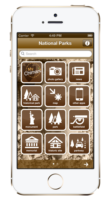 Chimani was actually created in 2010 with only a few parks at initial launch. However, since then the app has expanded to include 15 parks with professionally designed maps, handwritten and first hand accounts and suggestions for particularly beautiful or unique sights to see while in the park. Normally I wouldn’t really advocate using a phone while in the great outdoors—isn’t the whole point to get away from some of those distractions, after all?—but this app really has everything you’d need.
Parks currently included in this app are:
- Acadia National Park
- Baxter State Park
- Bryce Canyon National Park
- Cape Cod National Seashore
- Cuyahoga Valley National Park
- Glacier National Park
- Grand Canyon National Park
- Grant Teton National Park
- Great Smoky Mountains National Park
- Olympic National Park
- Rocky Mountain National Park
- Sequoia & King’s Canyon National Park
- Yellowstone National Park
- Yosemite National Park
- Zion National Park
The app itself works completely offline so you won’t have to worry about signal while hiking up a mountain or standing under some of the tallest trees in the States. It is free to use and download and is available via iTunes, Google Play and the Amazon App Store.
While Chimani advertises itself as a replacement for a paper map, I might still suggest that you take one with you anyway. After all, a map can’t run out of batteries.
Check out the video from Chimani below for more info: