 Robert Bennett of Pickatrail.com thinks so. In a post titled “Smartphone Trail Apps and Cartographic Spam on the Web” he lays out the case.
By cartographic spam, he means smartphone-collected tracks that show up online on sites like EveryTrail.com, that have significant errors in them. It’s a well thought out piece that breaks down the type of errors you see and goes into the reasons why smartphones are poorly suited to track collection. Consider this section on static navigation filters:
Many smartphones use GPS chips with static navigation filters enabled by default because the devices are used in vehicle navigation. Static navigation filters block spurious readings when the smartphone is moving slowly, for example as a car rolls slowly towards a stop sign. If a hiker records data from a trail using a smartphone while velocity is less than 50 feet per minute, GPS chips with static navigation filters can increase the probability that erroneous data is recorded.
He goes on to blame not only these apps for the problem, but search engines for indexing such poor quality content, pointing out that…
Hazards in the outdoors are always present, but this is especially true when visibility is reduced or the ground is featureless, for example when there is snow on the ground. If a person downloads inaccurate and erroneous points and follows them on a GPS device to a hazard while visibility is reduced or the ground is featureless then death or injury is possible.
His post raises many good questions:
- What responsibility do users, app makers, web publishers and search engines have in ensuring accuracy?
- Is it possible for search engines to filter out poor quality GPS tracks?
- How significant are the liability issues?
- Is it reasonable to expect a user to match up exact trail names when they may be hiking a loop that comprises segments of several trails?
I frequently use such sites to download tracks of trails, and I have seen plenty of errors. The worst are often easy to spot if you’re somewhat familiar with a trail, but I’ve often been out on the trail before I realized the errors.
What do you think about this issue and how can improvements be made?
First and foremost, most smartphone users need to be re-educated on the limits of their devices.
Smartphones should never be used to create track logs, period. Even when using the best consumer grade dedicated GPSr users must allow for a minimum 30′ potential error in perfect conditions. Add any atmospheric interference, tree cover, canyon walls and other obstacles that can block or bounce GPS signals, and the potential (and real) error is much worse!
I simply ignore all smartphone logged trails, and the websites that host them, as they are not doing their users, or any one else any favors.
Of course, responsibility for your safety is completely up to the individual. If someone is foolish enough to use a smartphone to follow another smartphone’s track, and finds themselves getting lost or in trouble, perhaps a valuable life lesson can be learned.
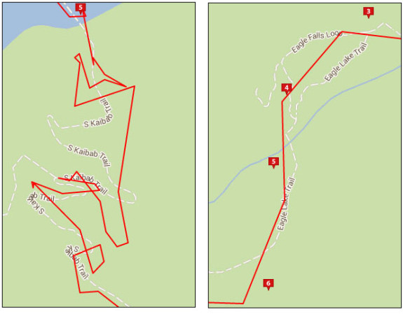
Here is an example from the Southwest Trails map (layered over satellite imagery) for the same area of the South Kaibab Trail shown above:
http://img577.imageshack.us/img577/4214/jojs.png
I think it must be possible to create a tool that can predict the accuracy of a track. I will ask ‘javawa’ (javawa.nl) to look into this..The guy is brilliant in analysing track-data and already made some very usefull tools.
If it will help on search engines is doubtfull, but it might be an end-user tool.
On the other hand: I always advise users to check a track on the computer. E.g. using Basecamp. Even without underlaying maps you will notice the ‘erratic’ behaviour.
@Atlas, Part of the problem is that every week there’s a new blog post announcing the best trail, hiking and skiing apps for smartphones. People who are just learning about outdoor navigation are reading these posts and they’re fooled into believing that their smartphone is a good substitute for a dedicated hand held GPS device. You’re correct in saying that most smartphone users need to be re-educated on the limits of their devices. I’m hoping the document I wrote will help a few people understand some of those limitations.
@Hans, After I record a track, I run the points through computer algorithms that I programmed which determine the horizontal and vertical accuracy of the points. I think search engines can filter a lot of the cartographic spam on the Web if they make that decision.
I plot points over online maps to illustrate the location of a trail. These points were simplified, so they’re not available to download to a GPS device. Instead, I provide points on custom maps, where the points accurately represent trails on USGS 7.5 minute topo maps. In this way, a person can determine their position on a custom map and use that as a reference for their printed topographic map. For more information about the custom maps:
http://www.pickatrail.com/about/maps/custom_maps.html
The above mentioned Javawa meanwhile built an easy to use tool (beta) to help to validate quality of a track. Have a look at it at http://www.javawa.nl/tqc.html
@Hans, “Perpendicular distance” is described on the page as positive and negative “deviation” of track direction. According to the help menu, this is supposed to tell us “…something about the accuracy of the track.” Trails traverse mountains, they zig and zag, some require bouldering. The direction of a trail does not help validate its quality or accuracy. Also, the angle between two track segments is not an indication of the accuracy of the track registration for the same reasons. Regarding the “Speed” chart, the help menu says, “An extremely large value indicates that the device didn’t determine the correct location.” I disagree, sometimes hikers take breaks to eat snacks, have a drink and enjoy the views–this requires time that results in “extremely large values” in the chart. I submitted a bogus trail that climbs the south face of Half Dome. It’s not possible to hike the south wall of Half Dome–a granite cliff–at the false elevation and points described in the file I submitted, so I would describe the trail as useless garbage, or very low-quality. The track analyzer did not provide any useful information about the properties of the trail. Computer algorithms can determine the accuracy of any trail but the “quality” of the trail is subjective. Perhaps you meant to type “accuracy”. Either way, this is something that requires a dedicated machine as it is processor-intensive. This is why the public trail analysis tool at pickatrail.com does not determine accuracy, it simply plots trail metrics.
In a proper tracklog the zigs and the zags wouldn’t be recorded by a single trackpoint each, but by a group of trackpoints close together; resulting in a relatively smooth track. When the log interval is too low or when the device isn’t accurate enough, you’ll get the spikes that are identified with this tool.
Regarding speed: staying for a longer period on the same spot will result in a very low speed instead of a very high one; even when you switch off the device in the mean time.
Note though that my tool doesn’t say anything about the quality of a track; it’s just a tool that shows certain metrics that maybe indicate the accuracy or quality. Also, the tool is still in its early alpha-stage…
The onus is on the hiker to be prepared, in my opinion. The best Garmin can have errors just as a smartphone can even in the best conditions with full signal. If you’re hiking in conditions such a low visibility and/or featureless ground then put technology down and bust out the manual instruments. I love my Garmin but I also hike with a compass, topo map of the region I’m in, and an altimeter as precaution.
So, can smartphone GPS devices endanger your life? Yes, if you are already disposed to letting the smartphone run your life. No, if you choose to use your brain as opposed to the mobile CPU. Technology is not far enough along to provide accurate turn-by-turn directions in the great outdoors (and who would want that?!). We still need basic navigation and survival skills when hitting the trail.
The headline of Bennett’s post is a bit sensational, even if I agree with the general sentiment that smartphone tracks are practically useless. The bottom line is If you are not experienced enough to properly prepare for the conditions under which a smartphone track would lead you to peril, then you shouldn’t be hiking those conditions in the first place.
@Javawa, Regarding Speed: In the track data I submitted there are two different consecutive points, each associated with different time stamps: 2013-06-01T01:58:37Z and 2013-06-01T01:59:39Z. This represents a pause in hiking and resulted in a very large spike in the chart. (All other time stamps in the track data are separated by a few seconds.) Regarding zigs and zags, the “…group of track points close together…” and the chart plot, whether smooth or spiked: The data and the charts do not provide any meaningful information about the accuracy of the track. I say this in response to your statement, “…it’s just a tool that shows certain metrics that maybe indicate the accuracy or quality.” Here’s the problem: To determine accuracy, we must first understand what is precise. Your track analyzer simply parses a track and makes calculations without knowing what is precise.
@Brandon, I agree with many of your points, especially regarding “…turn-by-turn directions in the great outdoors…” I wouldn’t want that either. On a related note, there are some places where it may be useful to have turn-by-turn directions on a trail. For example, on long-distance trails that pass through towns and cities. Regarding the headline of the thread, that was written by Rich Owings, the person responsible for the gpstracklog.com website. The document that I authored at pickatrail.com is titled “Smartphone Trail Apps and Cartographic Spam on the Web”. The document refers to points recorded by smartphone Trail Apps and uploaded to the Web which are “…inaccurate, erroneous spam that can cause death or injury to the people who download and use the points in the field.” The probability of death and injury is greater when the ground is featureless or visibility reduced, for example if someone is following a “Snowshoe Trail” that was recorded by a smartphone Trail App. I understand your bottom line, but there’s a lot of people who do not. There are Apps falsely claiming that smartphones can be used as GPS receivers at remote locations, as avalanche transceivers… on snowshoe trails. If a sensational title can get some of these people to read the truth–which may prevent an injury–I’m okay with that.
Yep, I take full credit for the headline.
Good discussion guys!
“This represents a pause in hiking and resulted in a very large spike in the chart.”
The length of the pause alone isn’t responsible for the spike in the speed chart. Speed is calculated as distance divided by time, so if you did stay on the same spot (like when taking a break), you wouldn’t get a speed-spike. The spike is caused by the fact that you moved the track points in your test track…
I’m not a regular hiker – came across this out of curiosity … I’ve had a Garmin 62s for years and I concede it seems more accurate than my Galaxy S3 or my Galaxy Note 4 … but I have to say when I use my Galaxy S3 / Note 4 for convenient sport reasons (running/cycling) or even just to record a walk easily as a personal record etc. then I’ve not noticed any great inaccuracy e.g. when overlaid on mapping the tracks seem to usually follow marked trails/paths etc. very accurately – only occasional & very slight deviations – usually where there are signal obstructions. I’m the first to admit to being poor at orienteering though I believe in plenty of planning & precautions … but for me the outdoors is about enjoying the outdoors. I’d be very happy with turn-by-turn instructions so I can spend more time looking around and not being anxious about losing my way. I don’t understand why it seems to be a necessity by many people’s measure to be able in orienteering in order to enjoy being outdoors? (nb. I don’t drive – I either walk/run or cycle including commuting … I like being outdoors – it’s not just an occasional past time to actually step outside though I lack time & money to safely [for me] visit places I’d like to often).