Hands on review of Navionics Marine & Lakes: US & Canada HD
The Navionics Marine Charting app is targeted for recreational boaters. This app allows viewing the proprietary Navionics Nautical Vector Charts on your favorite iOS device. Users can create routes and record tracks, which can be shared with friends using Facebook, Twitter, and email. The routes can also can be uploaded to certain fixed mount chart plotters that might be found on a boat. The Navionics app will function as a chart plotter displaying your position on the chart with the enabled route making it somewhat practical to use as a chart plotter while underway.
Various Versions
Navionics has quite a few different versions of their app. There are two basic versions in the app store: the “standard” version which runs on iPhone and iPod Touch. The standard version will of course run on the iPad at reduced resolution. The HD version of the app will run on the iPad at the full resolution, but can not be installed on the iPhone. Beyond the Standard and HD version, Navionics offers a different app for various geographic areas around the world. There are apps for the following locations: Europe, Australasia(sic) & Africa, Caribbean & South America, Australia & NewZealand, UK & Holland, Denmark & Greenland, USA only, and USA & Canada. This review will focus on the Marine & Lakes version for USA & Canada.
Updated UI
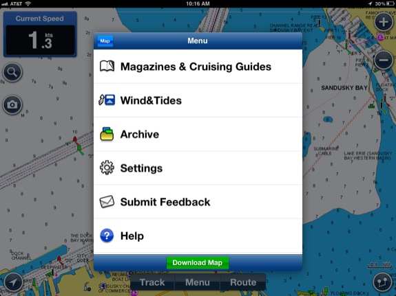
This latest version of the software includes some not so subtle changes to the user interface. Navionics moved some buttons around the chart screen and also massaged the menu structure slightly. Most of the changes are an improvement and make things a bit more logical.
Previously, saved routes and tracks were hidden under a cryptically labeled “i” button. Now they are available to recall under the “Menu” button, and then choosing “Archive.” A button to start recording a New Track is front and center on the main navigation screen along with a button to create a new route. The button in the lower left corner snaps the chart back to centered on the GPS position, and the button in the lower right corner brings up a quick and dirty distance and bearing measurement. The plus / minus buttons in the upper right corner, zoom the chart in and out. These zoom buttons may seem redundant as the standard iOS technique to pinch also zooms the chart. However, trying to pinch to zoom a chart on a touch screen while the boat is bouncing on the waves is almost impossible. The plus / minus buttons are a welcome addition! The upper left corner of the screen has a button to search the POI database and a camera button to take geo-tagged photos.
Navionics Vector Charts
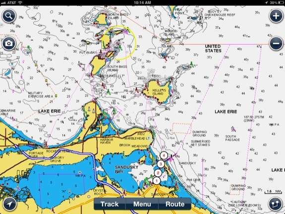
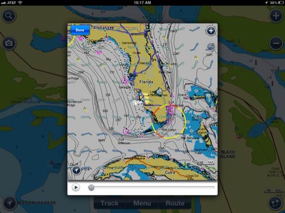
The chart set that is displayed is the proprietary Navionics Nautical Vector Charts. They are very clear and easy to read. The Vector Charts pan and zoom very fast. Initially, there are no charts downloaded into the app on the device. The app provides for a simple way to specify an area and download charts for that area. This allows the app to take up much less storage capacity as it allows the user to decide which charts are stored locally, and the end user can decide to refrain from downloading charts that might never be used. Charts can download using either WiFi or 3G, although it is recommended that charts be downloaded from WFi, especially if the 3G plan has data caps. Also keep in mind that 3G coverage on the water is not nearly as prevalent as it is on land, so charts might not download while underway. Task switching away from Navionics while the charts are downloading will pause the download. Task switching back to the Navionics app resumes the chart download. Previous versions of the Navionics app allowed the downloaded charts to be erased from local storage and then re-download the charts at a later time. The latest version does not allow users to delete charts and recapture any storage on the iOS device. Charts can be added at any time.
Various other information can overlay on the chart. Google Maps satellite view and Bing satellite view can overlay on top of the land areas of the chart, while the water areas remain the Navionics vector nautical chart. This is very useful when trying to find some land references while navigating on the water. It’s also useful when researching a new port of call while traveling. Reviewing the satellite picture can give an idea whether that port of call is a small town or big city. However, having this overlay enabled does slow down the refresh time when panning and zooming.
The safety depth can be adjusted depending upon vessel draft. This changes the colors of the depth contours. Any water shallower then the specified safety depth displays in blue, while all the water that is deeper then the safety depth is displayed in white.
The chart also includes POI data, including information about marinas. The POI data includes the appropriate VHF channel to hail a marina, whether the marina offers transient or seasonal slips, if there is fuel available at the marina and the phone number for the marina. Phone numbers can be dialed directly from the app if using on an iPhone.
It’s important to point out: If the Navionics app is purchased, only the Navionics app can use the Navionics Charts. These charts can not be loaded into any other GPS chart plotting device. These charts can not be shared with any other app on the same iOS device. iNavX is another iOS app that can use Navionics Vector Charts. However, the Navionics charts for iNavX must be purchased through X-Traverse, iNavX app will not share chart data with the Navionics app. This has confused quite a few people!
Routes
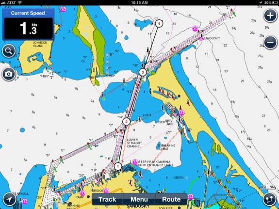
Creating a new route is incredibly simple. Touch the Route button on the Map screen and then choose “New Route” from the menu. The user then simply taps in every location where they want a waypoint. Each subsequent tap drops a new waypoint.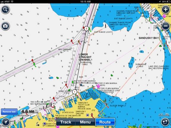
The first waypoint is automatically number 1, and the waypoints automatically count up as more waypoints are added to the route. These waypoint names can not be changed. While the user is creating a new route, the map can be panned and zoomed using the standard iOS techniques of dragging and pinching. If a waypoint is dropped in the wrong location, it is very simple to touch it and drag it to the correct location. Creating routes has never been this easy! Each new route is automatically named “routeXX”, with the XX being a number sequence that starts at 01 and works its way up. It’s a good idea to re-name routes to a more logical name immediately after they are created.
One unfortunate point to make: individual waypoints can not be named or saved independent of a route. Many people will have common waypoints that are used in multiple routes. This is not possible with the Navionics App. Each route must have it’s own completely unique set of waypoints that are numbered starting at 1. As easy as it is to drop waypoints and create a route, this is not a huge issue. However, it can get repetitive to keep creating the same set of waypoints over the same area a few times, if more then a few routes end up starting or stopping along a common navigation channel.
Live Navigation
Using this app as a primary navigation device while following a route is somewhat awkward. It’s disappointing that there is no Course Deviation Indicator while a route is active. The skipper must simply keep the boat icon on the route line that is indicated on the chart. This can cause lots of weaving back and forth and additional course corrections. Adding a compass ribbon across the top of the screen, or any other type of CDI would be a welcome addition and make this app much more useful for practical navigation on the water. All the route directions are indicated using True Headings. It is advisable to use the TVMDC method to convert the True headings to a compass heading and then use a magnetic compass on the helm as a CDI while underway. The skipper can reference the chart to visually observe any cross track error.
Other then the lack of a CDI, the app works very well for live navigation while underway. The screen draws and refreshes happen very quickly and smoothly.
I’d like to add that no skipper should use an iPad as the sole source of navigation data in unfamiliar waters. It’s fine to use the iPad as a reference tool in familiar waters, or possibly as a back up to a more robust GPS Chart plotter. Prudent mariners should always carry paper charts and a compass and know how to use them when transiting an unfamiliar area.
Route Sharing
The Navionics app has some really great methods for sharing routes and tracks with other devices and other people. Supposedly, the Navionics app will share all the routes with a Raymarine Chart Plotter with WiFi. I think this is a really great feature, but I was not able to test this feature as I do not have a Raymarine Chart plotter. This seems like a much a better way to program routes and lay them out in advance of a trip.
Navionics also allows sharing routes and tracks via email, Facebook and Twitter. Why would a person want to share routes and tracks on Facebook and Twitter? I can think of quite a few good reasons. If a club or group of people are cruising to the same location, one member can share the route with the rest of the group. Especially if that person has specific local knowledge that can be invaluable. If a person is cruising by themselves, sharing the route is the same as opening a float plan with family and friends. Instead of letting close family & friends know the float plan, it can be shared with many people across the Internet on Facebook and Twitter. When a Track is shared, this lets that same audience know that the destination has been reached safely. I think this is a great way for boaters to share the fun that they have on their boats and also allow those boaters to be more safe!
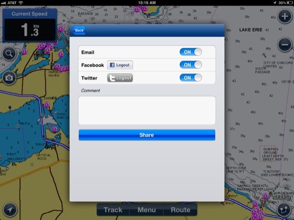 If a route is shared via email, then a KMZ file is emailed to the recipients. If a route is shared via Facebook and Twitter, then a link is created in the timeline that links to Google maps with the route on top of the Google map.
Wind & Tides
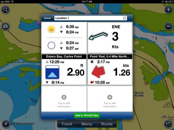
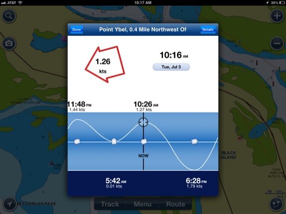
Navionics also includes some really great Wind & Tides information. A graphic can be brought up that indicates sunrise and sunset, the forecast wind conditions at the current location, the tide, and the current. By Tapping any of these graphics, additional information is displayed. For example tapping the wind forecast will bring up a small scale map of the current region and download GRIB files of the wind forecast every three hours for the next four days.
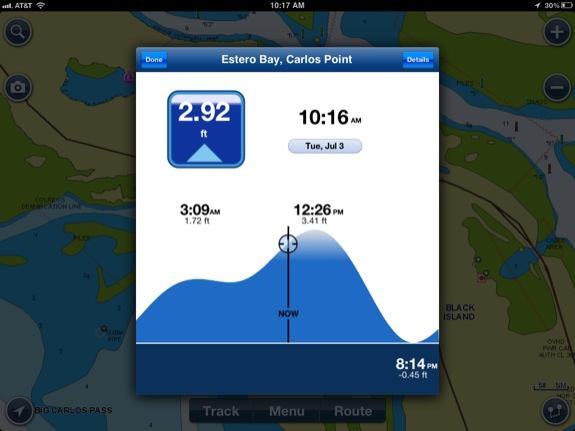 Tapping the tide graphic brings up a really slick window that predicts the tide. The tide can be dragged left or right to obtain the tide at any time in the past, present, or future. It’s incredibly intuitive and an easy way to see what the tide is doing. Tapping the Current graphic brings up a similar graphic where the current can be dragged to the left or right, to see the tidal currents at that location in the past, present or future.
Navionics Pros
- Simple route creation
- Simple track recording
- Sharing routes & tracks with social media
- Vector charts
- Intuitive Tide Diagram
Navionics Cons
- Lack of CDI or highway screen
- Can’t save individual waypoints
- Will not share charts with other apps
 Conclusion and Recommendation

Recommended. For pre-plotting courses, or doing “armchair” cruising, this is a great app. Mariners can reference locations on the charts to see that an area is clear of hazards. The app is also great for programing routes into a Raymarine or other supported chart plotter. This app utilizes the most simple way conceivable to create and edit routes. The Vector Charts pan and zoom very fast, and provide great detail. Although it will work for live navigation while underway, this is not the best app for that purpose, since the app lacks any type of CDI or highway screen.
Hi Bob, great article! Do you know if there is a way to hide the last track used on the iPhone version of the app?
Thanks!
David
Fellow USPS Member
Assuming that you have the track already stopped and saved, you can tap Track-> New Track. This starts up a new track and removes the previous one from the screen. Next tap Track->Stop&Delete. This will immediately stop the new track and delete it. Now there is no track showing on the map screen. Not sure if that’s the “correct” way to do it, but it works!
How is course over graund and heading displayed on navionics?
I use a Samsung Gallaxy 2 7.0 tab
Sorry, I don’t have an Android Device to do any testing. It’s one of the things that I pointed out was missing from this version of the iOS app.
Hi Bob,
great article! Amy be you have an idea or answered the question Way the TRACK does not appear on the as button on my iPad – as it does on my iPhone? All navigation settings of iPad are switched ON.
best regards and thanks for a tip,
Thomas
Lake Thun Switzerland
Hi Bob,
great article! Any idea or answered why the TRACK BUTTON does not appear on my iPad – as it does on my iPhone? All navigation settings of my iPad are switched ON.
Sorry for the typos in my last post – German Kyle board was switched on.
best regards and thanks for a tip,
Thomas
From lake Thun Switzerland