Augmented reality for the backcountry
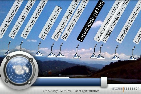
Peak.AR is a free augmented reality app for the Android and iPhone platforms, that allows you to identify distant peaks by simply pointing your phone’s camera at them. Pretty cool huh?
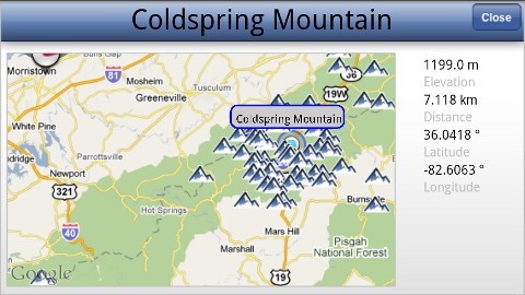
I mentioned this app before, but now that its available for Android too, I wanted to delve into it a little more. Once you get into it though, it’s a bit bare bones. There are no settings that allow you to switch from meters to feet. You can tap a label to see a 2D map view, giving distance to a peak (see below). Holding the phone flat also switches it to a 2D overview map. I do wish the app would cache peak data, rather than having to reload it each time, putting its usefulness at the mercy of backcountry cellular coverage. Regardless of its limitations though, this is an awesome tool for determining what distant peaks you are looking at.

Electronic compasses are very sensitive, so don’t expect this to work if you’re standing near a large metal object like your car. I suggest calibrating the compass on your phone prior to using this app, just like you would any tri-axial compass, by rotating it in all three planes. Here’s a video demo showing how it’s done with a handheld GPS receiver. Speaking of which, it seems like handheld GPS manufacturers could integrate this functionality into units with a camera (hint, hint).
I tested this app on my Motorola Droid. You can get the iPhone version at iTunes; for the Android version, search the Market for Peak.AR or scan the QR Code below with the Barcode Scanner app.


the QR tag appears to point to an App that does not exist in the Android Market.
Huh, just tried it and it worked for me.
Tried it on my Droid X; almost worked once, then crashed. Now doesn’t even start up. That seems to be a problem with Android OS and hardware fragmentation; getting an app to run on every platform appears to be a problem.
Jealous! (Droid X, not the Peak.AR fail).
I think there’s room for more players here, BTW. Not sure why Michael of Hey What’s That hasn’t approached this any more aggressively than he has. He’s set up for mobile, but it doesn’t have the elegance an AR app needs.
Different skills set – Android currently requires Java for apps, and I’m guess Mike’s doing it in Javascript.
Boy, do I love my Droid X! I’m seriously thinking of learning Java to work with it. Garmin had better be looking long and hard at Android, or they’ll be out of the handheld business in 5 years. I’m already re-thinking whether I need a 62s.
I can’t wait for Garmin to release a ruggedized Android phone. I’m fully expecting it, though it could be a couple years away. If they wait too long, there will be other players competing in the same space. Others may be able to have a good go at the hardware side, but Garmin has a huge lead on software.
Nice app, but quite imprecise IMHO.. PeakLens (peaklens.com) for example corrects the compass error, and provides precise peak positions