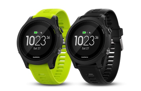
This week in GPS is a weekly link roundup of (mostly) GPS related odds and ends, from GPS Tracklog and other places around the Web. This week’s featured image is, once again, the Garmin Forerunner 935 that was dropped last week. Read about it and other GPS news below! read more
Garmin Announces New Forerunner 935
Last week, Garmin released the newest device in the Forerunner series. The Forerunner 935 is aimed at serious athletes and has the ability to track multiple sports including running, cycling, swimming, skiing, golf, hiking, and others. The device features both GLONASS and GPS and is compatible with a variety of sensors for measuring exercise statistics.
At first look, the Forerunner 935 stands out from the rest of the Forerunner line with a more slim appearance–more like a smartwatch than a running watch, which may have been the intention. This device shares many features with the fēnix 5 Series, including the replaceable QuickFit bands, but rather than just being a generic watch for active people, the Forerunner 935 is focused entirely on athletes looking to get the most out of their given activity. read more
APE Cache Mission 9 to be Reactivated
In November 2016, a team of dedicated geocachers went searching for one of the missing APE caches. The Mission 9: Tunnel of Light cache was muggled in 2011 and the original container was thought to have been stolen. However, the original box bearing the APE logo was recovered, and Groundspeak put out a call for the geocaching community to decide its fate. And, as the headline says, geocachers overwhelmingly voted to reactivate the cache.
More than 10,000 geocachers took part in the voting process, which was launched at the end of February. Voters were given four options: to activate it once a year, to display it at Geocaching HQ due to its historic nature, to make it a traveling artifact, or return and reactivate.
Here’s how the actual vote percentages broke down: read more
For the First Time, FAA Approves a Drone to Fly at Major Airport
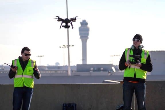
If you’re a drone user, then you are probably aware of the almost draconian rules on flying your aircraft. There are restrictions to height and location which vary by region and even situation slightly. However, the one constant is that drones are not allowed to fly near airports. However, in a landmark moment, the FAA recently issued a waiver and allowed a drone to fly at the Hartsfield-Jackson Atlanta International Airport—one of the busiest airports in the world.
The exception, it should be noted, did come with some conditions: in order to allow the drone to fly in airspace, the drone would require three spotters to be watching the drone during its flight, and there would have to be intense coordination with air traffic control. Of course, this isn’t the first time a drone has flown at an airport, but it is the first time the special permit was granted for a major airport. read more
This Week in GPS — February 3, 2017
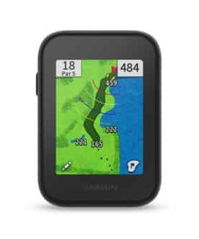
This week in GPS is a weekly link roundup of (mostly) GPS related odds and ends, from GPS Tracklog and other places around the Web. This week’s featured image is Garmin’s newest golfing GPS unit–the Approach G30. Read more about it, and other GPS news, below! read more
Couple Uses GPS To Announce Pregnancy
Here at GPS Tracklog, we write about a lot of hard news like product releases and technical information about the state of GPS in the country and world. It can be easy to forget that GPS is way more than Garmin’s latest navigation device, or that cool new Kickstarter program, or even geocaching tips. But, GPS can be used for a variety of more fun things, including hiding art, jogging for marriage proposals and everything in between. Today, I wanted to pause in all the technical stuff to write about an adorable human interest article I stumbled across at Little Things.
Recently, a couple posted a video online of a pregnancy announcement made in a very unusual way: through the device’s GPS voice navigation. There aren’t a lot of details on exactly how it was done, but watching the video, it looks like the woman may have used Siri from Apple Maps for the announcement. The reactions of the mother were pretty priceless.
You can watch the video below:
read more
Simplifying Buying a Handheld GPS
When you star researching to buy your first handheld GPS, it can be a little daunting. There are so many different options, plenty of advanced features (including some like a camera which seem kind of useless at first) and often multiple versions of the same unit with different numbers, slightly different features, and a huge difference in price. So how do you pick?
Turns out, it doesn’t have to be as complicated as you think. Obviously you have an idea of about what you want to spend, and that’s the simplest way to narrow down your choices. Then, there are really only three things you need to decide: read more
This Week in GPS — December 30, 2016
This week in GPS is a weekly link roundup of (mostly) GPS related odds and ends, from GPS Tracklog and other places around the Web. This week’s featured image is an airplane because GPS and Galileo both have announced that they will be working together for airline safety. Read more below, and other GPS news as well: read more
GPS, Galileo to Work Together For Airliner Navigation
If there’s one thing that never fails to make people sit up, pay attention, and finally work together, it has to be air travel and safety. In 1983, President Reagan opened up GPS for civilian use after the Korean Air Lines Flight 007 was shot down when it strayed into Soviet airspace. Then, in 2000, GPS accuracy was increased as President Clinton ended Selective Availability. Now, it looks like the aviation community may get yet another tech bump in the near future.
According to the Wall Street Journal, the United States and the European Union have agreed to work together to allow aircraft to access both GPS and the yet-unfinished Galileo signals, providing better and more accurate navigational information. With this initiative, each system would be working as a backup for the other, providing more protection against hacking, jamming, spoofing, and other similar threats.
Norad to Track Santa’s Trip
Christmas Eve is finally here again, which means that the countdown has begun for Santa and his elves to get all of the presents loaded up, the naughty and nice list checked again, and the travel plans made. But, have you ever wondered how Santa manages to visit all of the children in one night? While I’m don’t know what we’ll ever know exactly how he manages it all, one thing that we can be sure is that he definitely visits all the children of the world, giving out presents. And how do we know? Well, by tracking him via GPS, of course!
In fact, since 1955, the North American Aerospace Defense Command (NORAD) has been tracking Santa’s progress on Christmas Eve to make sure that the jolly man doesn’t run into any problems on his flight. While originally they used radar to hone in on Rudolph’s shining red nose, in the modern era, advanced GPS technology, specially-designed SantaCams, and input from the elves that make up Santa’s flight team allow NORAD to track exactly where the jolly man himself is delivering toys throughout the night.
