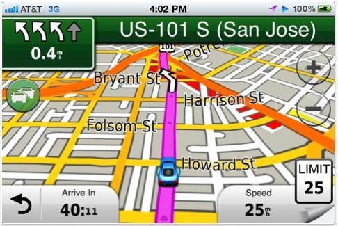
 Recalculating! Garmin has done a course correction with their iPhone app, rolling out a version with onboard maps, eight months after the release of their original StreetPilot app that used offboard maps. Considering AT&T’s reception problems in many areas, it’s probably a smart move.
As of this morning, the original offboard version is still available, and it doesn’t look like owners of that app will be getting a free upgrade. The new app debuts with three versions:
- U.S.A. (Lower 49 United States) – $39.99
- North America – $49.99
- UK & Ireland – £44.99
 An in-app purchase will offer live traffic and fuel price subscriptions. Here’s the full news release.
I would have hoped that I would be at least offered a discount to upgrade to onboard maps from my off board version. I paid $30 for the original app and can’t justify spending another $40 or $50.
Yeah, kind of sucks, huh? Maybe they’ll offer it as an in-app purchase deal.
wow it doesn’t use wifi or data plan? nicee..
but its sort of a downer that ppl who own the original app cannot upgrade for free
Hey guys. I’ve been using this for quite a few days. Here’s my review on it!
GPS NAVIGATION AND ME
First of all, my nerdy fascination for GPS Navigation started with DeLorme’s Earthmate back in 2003. I have always been fascinated by GPS technology, and will use a navigator even if I know where I am going. I have enjoyed seeing the evolution of Garmin’s navigators ever since being absolutely blown away by my iQue 3600 in 2004. Garmin continued their ascent in the business with the StreetPilot 2730, which was light years beyond the 3600! No other GPS maker could touch Garmin. With the release of TONS of Nuvi units in late 2009 , I became confused with all the options. I bought an 885T, and a 3790T. It seemed these Nuvis would be discontinued faster than they were being released. I eventually discovered Navigon’s MobileNavigator in 2009, and sold my Nuvis on eBay. Since 2009, Navigon had my loyalty, and I felt Garmin had slipped behind other companies. In the last month, I feel as if Garmin may be on the way back to a firm no. 1!!! Their new Nuvi lineup for 2012 is streamlined, refined, and boasts features not ever seen on other navigators. Their release of several new iPhone apps for different people’s needs compliments these new navigators.
GARMIN NORTH AMERICA APP
After using Navigon’s MobleNavigor for two years, I did not think navigation could get better. Garmin’s release of the StreetPilot App earlier this year was a mediocre success at best, but the latest August 31 update improved the app fairly significantly. Some features that were added are not yet present on this app, but we will get to that later…
Overall Navigation
As on most of Garmin’s Nuvis, you are given the option of Faster and Shortest routes. After trying several destinations, the routes were quite good. The estimated time of arrivals were also quite reasonable. This is further enhanced by the inclusion of TrafficTrends which I was surprised to see included with the traffic subscription…
Traffic Services
For $19.99 a year, traffic data for several metropolitan areas are included. Here in Chicago, this is a lifesaver and well worth the $19.99. The traffic data has been reliable, and it appears that accidents and major delays on secondary roads are also being reported. If you are routed off of a highway due to traffic, TrafficTrends is also included with the traffic subscription…
TrafficTrends
TrafficTrends uses a variety of sources to collect data about congestion of secondary roads at different times on different days. This is used to enhance your route by keeping you off of roads that are historically congested at certain times of the day. Out of the 20 or so trips I have taken, I have completely agreed with 18 of these suggested routes. TrafficTrends has successfully avoided many notorious intersections during rush hour. The combination of Traffic and TrafficTrends is an extremely worthwhile tool. The ETAs in rush hour traffic are not yet on par with Tom Tom’s IQ Routes, but the routing (at least in Chicago) seems to be more efficient.
Fuel Prices
For $9.99 a year, you can also have fuel prices downloaded to your Nuvi. It works well, but is unnecessary with all the gas finder apps out there.
Lane Guidance
Where available, arrows are shown in the upper left hand corner showing what lane to be in at the next turn. This is, in my opinion, the best executed lane guidance of all navigation companies.
Junction View (NOT YET Garmin’s new PhotoReal)
Junction View is an actual illustration of the signs and lanes of a junction. Very few interchanges are covered in the Chicago area. On the new StreetPilot app update, Garmin’s brand new PhotoReal junction for North America is included. The difference between Junction View and PhotoReal is MAJOR. Not only are an extraordinarily significantly greater number of junctions covered (I noticed at least 10 more in a 15 mile stretch) but all surroundings, buildings, street lamps, signs, trees, and overpasses are realistically recreated when shown. It is an AMAZING new feature I hope is included in this app on the next update.
Favorites and Contacts
Has the ability to store favorites. This is a cool feature, as you can come up with some pretty creative names and the text to speech announces it when you arrive. For example “Continue .3 miles to Kurt’s Mansion of Glory on right”. If you have an address stored in your contacts, this can also be used right from your phone.
POIs, Google Search, and Exit Services
There is a decent database of Points of Interest, but has some outdated locations as well as some new locations not included. Google Search is included and is always up to date. Exit Services is a new feature that let’s you see all points of interest that are near each exit on a highway as you travel, VERY helpful!
RED LIGHT CAMERA and SPEED LIMIT ALERTS
A red light camera database had been included for free, and allows you to add your own red light camera reports by clicking on the Speed Limit icon. An alert sounds when you are approaching a red light camera. Speed Limits are shown on the screen as well, and you have the option of being warned when you are 5MPH over the limit.
Other features
-trip computer
-trip planner, letting you make multiple stops.
Interface
The interface is gorgeous, with Garmin’s standard Nuvi Menu. WHERE TO? And VIEW MAP. The maps are by far the most beautifully done of any iPhone Navigator, and zoom in and out automatically as you travel. There is no word yet on if map updates will be free, or if they will have to be purchased. Traffic is shown as color coded shadings along the roads, along with incidents. The map can get a little crowded when zoomed out, but is still really nicely done. 2D and 3D maps are available. Next turn previews are included, as well as a route overview. A trip computer is also included.
WHAT WILL MAKE THIS A 5 STAR APP?
-Inclusion of latest maps. The ones on here are several months old compared to the new StreetPilot app update.
-Inclusion of PhotoReal Junction Views.
-Pedestrian and transit mode. Though not something I really care about, if it exists on the StreetPilot app, why not here?
-MyTrends, which is a service that analyses your driving habits and adjusts ETAs. It also predicts places you are going based on daily habits and automatically routes you there.
OVERALL
As stated before, I am a GPS nerd. I plan on buying Garmin’s new Nuvi 3490LMT and at least trying it out when it comes out. I also have the navigation apps of Navigon MobileNavigator, Magellan Roadmate, Tom Tom USA, Waze, CoPilot Live, Garmin StreetPilot (Maps downloaded as you drive through data connection), and MotionX. I consider myself qualified enough to tell you that the Garmin North America app is my current pick for Best Navigation App for the iPhone. I am looking forward to future versions!
Great review Kurt! Thanks for taking the time to share it.
Thinking of trying the Street Pilot Onboard app, )I have offboard now) but before I do I would like to know how much they are going to charge for the map updates every year….does anyone know?