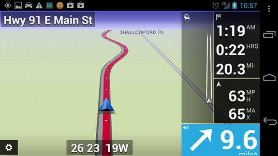
TomTom for Android map screen
The long-awaited TomTom navigation app finally came to Android in October, only to disappoint those of us with larger screen phones like my Samsung Galaxy Nexus, which weren’t compatible. Fortunately an early December update brought compatibility to a larger range of phones and I’ve been testing it on and off ever since. How did it do? Read on to find out…
TomTom for Android interface
Though the map screen is a bit different, with data shifted to the right side, other parts of the interface will look familiar to TomTom users, as you can see in the screenshots below.

TomTom for Android drive to menu

TomTom for Android settings menu
What I liked
- IQ Routes was smart enough to take local shortcuts, keeping me off clogged major arteries
What I didn’t like
- Unlike with Garmin’s Smartphone Link app, you can’t select a location from Google Maps and have it navigate using the TomTom app
- Selecting a favorite to route to takes six steps
The rest
The app displayed some routing errors, but so did a Garmin nuvi I tested it against. I’m not a big fan of mobile apps for navigation, nor do I live in a traffic-clogged area, so I’m probably not the best test case. For me, Google Maps Navigation meets my needs for those times I need navigation and don’t have a PND with me.
Thank you for the review. I have been waiting to get a new smartphone because I want to get one compatible with Garmin off line navigation. Right now that would be an iPhone. However, since I am on T-Mobile, I may have to wait awhile longer. I am hoping that at some point Garmin will release a Garmin StreetPilot for Android version. By any chance does anybody here happen to know if Garmin will ever have an Android version?
The last I heard was something nebulous like “we’re looking into it.”
Some of what I didn’t like:
POI search results are in a list showing only distance from current location, without giving any more details about where each one is located. You can chose which POIs show up on the map view:
http://i1306.photobucket.com/albums/s561/GoneNomad1/TomTomScreenshot_2013-03-041_zps84e35ffc.png
and they show up like this (when viewing the map):
http://i1306.photobucket.com/albums/s561/GoneNomad1/TomTomScreenshot_2013-03-042_zpsdc420f69.png
as subcategory icons, although logos show up in some cases.
But if you want to search for a POI by name, after choosing “search POIs” and then typing in what you’re looking for, you get a list like this:
http://i1306.photobucket.com/albums/s561/GoneNomad1/TomTomScreenshot_2013-03-043_zpsa4ca4b7a.png
which shows only how far each one is from the current location (without even the address that shows up on some PNDs, or the arrow showing direction that you see on Garmin PNDs) even though there’s plenty of room on this screen for more information – on a tablet, at least, but most of these apps are rarely ever truly tablet optimized.
You have to pick each POI, one at a time, to see it on a map, and when you do that, you get a map like this:
http://i1306.photobucket.com/albums/s561/GoneNomad1/TomTomScreenshot_2013-03-044_zpsaa57cb61.png
which does not show where that is relative to the current GPS fix, and does not allow you to scroll/pan around in that map to get some idea of the surrounding area. If you don’t recognize where that is based on the default map as shown in that image (as you might not do if in an unfamiliar area), then you’ll have to chose to navigate to a POI just to get a better idea of where it is. All of which is pretty stupid, but then again most PNDs work pretty much the same way, although some allow pan/zoom from the screen comparable to the one shown above. In this respect, Magellan’s PNDs are better, as they allow you to see something more like the “map view” screen above. And the Navigon MobileNavigator app is better too. I have a lot of screen caps of Navigon, and will see if I can find them when I have time.
BTW, that “Walmart” that’s at the top of the list above, and on the subsequent map image… is bogus. There is no Walmart there (never has been), although there is a Sam’s Club not too far from there (google had it wrong for many years, but after about the third time I notified them, I think they finally fixed it). At least TomTom does get some others right that Garmin and Magellan have had wrong for years. But all these apps and PNDs have problems with POIs. Fortunately, I know how to find these flaws (and a lot more) and that’s exactly what I look for when I put an app or PND through its paces.
Another area where Navigon is superior to TomTom is in picking an alternate route. TomTom allows this too, but it’s much more cumbersome than in Navigon. But neither one necessarily offers the choice of the alternate route you may have actually wanted, and neither allows routes to be changed by dragging them (like google maps, or S&T). In most cases, the alternate route can be forced as you’re driving, simply by driving the way you want, usually at the beginning of the route, at least for short trips. For long trips you’d most likely have to make it a multi-step trip by adding waypoints.
In some circumstances, if you go off the pre-planned route, TomTom keeps trying to make you turn around longer than it should. It doesn’t always do this, but one way to uncover this is to plot a route that takes you onto an outer (access) road roughly in the middle of two freeway entrances, and then chose to turn the opposite way as on the preplanned route (since either way will work) – in this circumstance, TomTom takes longer than either Navigon or CoPilot to recalculate a new route, and until it does that, it keeps telling you to turn off (not turn around) longer than it should.
If the TomTom app were able to be the default navigation app a lot of what Nomad says would be better using another local search app. TomTom’s online poi search is terrible.
The ability to have custom POIs would also cure some issues.
Mapshare is another issue. 3 times I have reported a closed exit heading south bound from Rt 138 in Tiverton, RI onto Rt 24 and TomTom shows the northbound off ramp from 24 to 138 blocked. I am not reporting it wrong either.
Point being on my own PND at least I would have that for my own routing but I don’t even have it because Mapshare is not associated with the software version.