 In my last post I looked at several GPS features you don’t need. Today we’ll check out the flip-side, updating my post from several years ago. What are the best and most useful upgrades when choosing a navigator? I’ll start with ones available on relatively low end units and then move on to features found on more expensive models.
Lane assist
Have your GPS show what lanes you need to be in for an exit, or even on surface streets in some cities. Priceless!
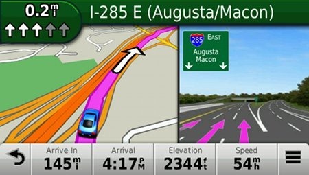
Junction view
And if Lane Assist is too subtle for you (or you space out easily), there’s nothing like having a picture of the exit pop up to say, hey, here’s your turn!
Wide-screen
Do not buy a 3.5” GPS navigator; 4.3" is the minimum for most people and you may be happier with a 5” model. A bigger screen makes it easier to tap menus and enter text without error, and the map display isn’t as cluttered.
Speed limit display
Got a lead foot like mine? Most models will even show your current speed in red if you are exceeding the limit.
Lifetime map updates
It is cheaper to buy these bundled with the device than as an add on later. If you live in a never changing rural area, this probably isn’t that important to you. On the other hand, if you’re in a fast growing metro or an area plagued by highway construction, look for models with an M appended to the model number.
And if you can afford them…
I highly recommend the above features. The next ones may not be as critical, but are definitely worth paying extra for if you can swing it:
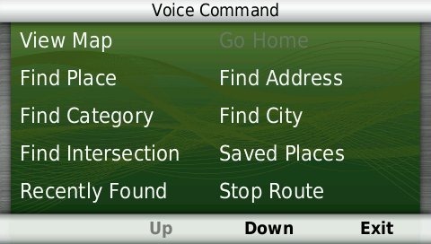
Voice command
Distracted driving is a serious hazard to your health. The latest voice command models from Garmin and TomTom have generally performed very well. This is an especially important feature if you’re driving solo.
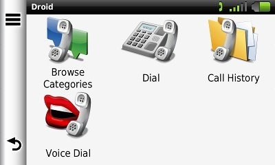
Bluetooth
Previously on my do not buy list, many of the latest models have dramatically improved sound quality. Read my reviews for details before making your selection though, as quality and ease of setup does vary.
Powered mount
With these, you don’t need to fumble with the mini-USB plug each time you get in your car. Recent Garmin nuvis with this feature include the 169x, 23×0, 24×0, and 3xxx series.
Your turn
Do you agree or disagree with the above list? What have I left out? Chime in below.

Hello,
I disagree strongly with two of your first “not useful” list.
Traffic is very useful where I live in the Seattle area.
Portrait mode is preferrable because it shows what is coming and not a lot of things off to the side that are not where I am going. If the GPS is mounted properly it will not obstruct view in either portrait or landscape mode.
Thanks
Steve
I have a Magellan for the RV and it chimes as you exceed its known speed limit. Set at 5mphby above the speed limit by default, it is a nuisance and soon is ignored, but I then set it at 10mph above the speed limit, it is good, even better than Garmin’s red box reminder. (I was running both units)
Hello Rich,
I wanted to say I enjoy your site but have a question. My wife decided she wanted a gps and noticed several on sale for Black Friday. She doesn’t really have a preference for models but I am biased for Garmin. I have noticed that the 40Lm, 50Lm the 1490LMT and the 2350LMT are on sale. Should I just go with the middle range gp?. We don’t live in a busy metro area like Atlanta or Dallas, Houston or anything like that, but we may take trips to those cities. Any help would be greatly appreciated.
Thanks.
Of those choices, I would go for the 2350LMT for the powered mount, but they are all good units.
One feature that I like, that I don’t believe Garmin has ever offered, is a Next Turn symbol on the main map screen that is always there while routing. It shows if the upcoming maneuver is a hard left or right or merge type turn, etc. IGo software has this and also has a smaller symbol for the 2nd turn you will be taking after the first. A further enhancement is the Next Turn symbol will be highlighted in some way (turn red, for example) as the next turn is imminent such as 100 yards to the turn. For those of us that are visually measurement challenged the latter is a big help. Also helpful when multiple turn choices are present. Granted it is a bit more screen clutter, but many of us don’t mind and it outweighs the usefulness and safety factor.
I guess I’m not keeping up with newer Garmin models as I see they do offer Next Turn symbols. Do they highlight as the turn is imminent?
It’s not highlighted in any way. It’s always there in the upper left corner of the screen though. The turn is called out a bit ahead of time and then again right before the turn.
Hi Rich,
I am thinking of the 2350LMT or the 2450LM, according to your comparison chart they both have powered mount but when I look at the Garmin site or on Amazon this is not mentioned in the description. I just want to be sure before I order. Thanks Anita
Yes, they do. You can see pictures and a discussion of this in my reviews…
http://gpstracklog.com/2011/02/garmin-nuvi-2350lmt-review.html
http://gpstracklog.com/2011/03/garmin-nuvi-2450lm-review.html
I have been trying to figure out what bluetooth is on gps, I don’t even really understand it on a cell phone. Therefore, I didn’t really get your explanation for bluetooth. I don’t have an iphone or smartphone, just plain muti-text. I don’t know if my cell phone service has anything to do with the bluetooth on gps, but just wonder if bluetooth can still benefit me.
It allows you to use the speaker and microphone built into the GPS for phone calls, so you don’t have to hold your phone while driving.
Camera alert for known traffic camera locations – It can save you drivers license!
My wife’s Garmin nuvi 2360 does camera alerts (not mentioned in the sales info) the 2360 has no manual so who knows what else it does.
Bluetooth – for cars GPS only lets you talk on your bluetooth cell phone hands free.
Bluetooth – for motorcycle GPS works like the car bluetooth, but it also can talk to you and listen to you through your bluetooth earpiece! Not bad if you drive a noisy vehicle, convertable, jeep, etc.
I find one of the best features is being able to rotate the GPS to portrait view. Who cares what’s on your sides. What you really want to know is whats in front of you.
I thought I would like that feature too, but I rarely use it. I guess I find the landscape orientation works better for me in terms of how much or little of my view it blocks. There also seems to be a trend by Garmin to use the sides of the the landscape display for other info (map buttons, etc.).
One feature I subscribed to on my old Tom Tom ONE V3, is the gas stations. Unlike GasBuddy (IPhone App), it not only listed local gas stations by price or distance, but also listed the gas stations between my current location abd my destination, with prices. I am a Snowbird, and my vehicle does get up to 18 mpg, with a 24 gallon tank. So it is really beneficial to “pick” my next best low price fuel up station. Does anyone know of any app for the Garmin units that will do this? The other biggies (for ladies comfort), is being able to pick out the Next Rest Stop. TomTom had a free app for that, but both had to be preloaded daily from my PC into the TomTom ONE.
The TomTom GPS App for the iPhone does not support the gas station “aong the route of travel” feature, and some states, like Massachusetts, does have a prohibition (illegal) to READ from the iPhone while driving OR while stopped. Buta dedicated GPS is exempt from that rule.
For Android maybe (not sure if it does along the route or not), for iPhone no (not yet anyway). But there are other third-party fuel price apps.
Does anyone know of SW/DB to identify the Points of Interest stops along roads throughout the nation that can be loaded to our nuvi 1450?
Thanks
What kinds of POIs do you want? Here’s one source…
http://www.poi-factory.com/
I am currently shopping around for a GPS, reading lots of reviews but, for whatever reason, most of the reviews are quite varied. Some are even dramatically different. So I’m having a bit of trouble deciding whats best for me. My price range is only around $150. For obvious reasons I’d prefer a 5″ screen, but that isn’t the biggest issue. In a few weeks I’ll be doing a lot of traveling through, West Virginia. It’s easy to get lost here sometimes, and most of the places I’m going to are in the middle of nowhere. If the GPS doesn’t have the proper roadways, and takes me in the wrong direction, it could be a major problem. No gas stations, no cell service, no likely hood of a passing vehicle, kind of problem. Suggestions? Other than me staying home that is.
People are quicker to post negative reviews more than positive ones, so all online reviews seem to skew that way. Your best bet for proper roadways is to get a model with lifetime map updates or a latest map guarantee and update it before your trip.
You’re definitely right about the negative reviews. It was a little overwhelming. Even the customers were pretty skewed. Most of the customers that had problems with wrong directions, ect, didn’t say that they updated before using it. I’m considering the Garmin nüvi 1450LMT. I managed to find a few decent deals right in my price range. I’ll have to pick up a powered mount and a car charger though. There weren’t many grouped together. I’ll just shop around a bit longer before deciding. Thanks for the quick response. I really appreciate your help.
Just so you know, the 1450LMT won’t accomodate a powered mount.
Just discovered that before you responded. Thanks for the heads up anyway.
You recommend Lifetime Map updates, but since Garmin’s website won’t reveal how much an update costs (until you plug in a device to your computer and connect to Garmin) I was wondering if you could give me some idea of what an update costs? Say updating a 3450 once a year for North America? thanks
Looks like about $50-55 for lifetime updates. Surprisingly a one time update costs even more.
A sorely needed feature is the ability to display POIs not just in a list, but on a map (along with the current GPS position). This is particularly applicable when there are a lot of POIs in the area (e.g.: restaurants), and you may not want a specific one by name. Seeing them on a map can make it much easier and faster to decide which one you want. The best way to do this is with logo icons for major chains. Some units have a limited version of this, but most do not. Magellan and Navigon are the only two I’ve seen that have logo icons for many POIs. Garmin and Streets & Trips allow users to add icons for custom POIs (though each has serious flaws in the resulting display of those images), but not for the built-in POIs. Most users are never going to go to the trouble adding icons for POIs. It needs to be built in. Also, none of the nav apps or PNDs has implemented any option to show the POIs in a recognizably large size when zoomed out far enough to see the surrounding area, nor have has anyone implemented a feature to make the POIs “auto-arrange” into a grid arrangement instead of overlapping one another due to being positioned at their ‘exact’ location (which conflicts with the need to see them if not zoomed all the way in).
Seeing a list of POIs arranged by distance order doesn’t cut it, even if searching along the route, because in that list, a POI 10 mile ahead and 4 miles off the route will show up in ahead of a similar POI that’s 13 miles ahead and 1/4 mile off the route. It would be nice to be able to set how a search along the route is done, too (to limit the distance OFF the route).
There are also many customization features missing in the user interfaces of most PNDs, but from the looks of the newer units, the big three PND makers are slowly adopting some of the things that have been around in for many years in mainstream programs like Windows Explorer, Firefox, etc. I’m referring to features like shortcuts, tabs, view options, etc., features that have been part of operating systems, file managers and web browsers for decades (in some cases), that are only recently coming in dribs and drabs to PNDs & nav apps.
You can do this with the browse map function on the 2012 nuvis. Most TomToms allow it too.
True, you can browse the map on most newer Nuvis, but as far as I can tell, none of the models on display at local stores (including one of the higher-end 3000-series models) don’t do what I described above. I just got back from Sam’s Club, where I worked with a Nuvi 2555, and as far as I could determine, it did not do what I described above.
If I’m wrong, please let me know how you access a specific location, or see a particular category or sub-category of POIs on a map, when in the “Browse Map” section. Sure, you can see one at a time, or you can start to set up a route in the “Go To” section, and see a very small map on part of the screen. But that’s not what I’ve described above. And I am very certain that Garmin nor TomTom nor Magellan has their POI icons “auto-arrange” so they don’t blot each other out when not zoomed in all the way. Of those three, Magellan has more POIs show up with a logo, TomTom has a few, and Garmin has none, at least on the Garmin’s I’ve tried.
edit: none of the models on display at local stores do what I described above.
The model I tried at BestBuy was a nüvi 3590LMT
Neither one seems to have a way to look for a specific place directly in the Browse map screen. If it’s there, it must be invoked by a button that’s invisible until you press just the right spot, because I just tried the 2555LMYT at Sam’s
http://www.samsclub.com/sams/garmin-n-vi-2555lmt-5-gps/prod4910373.ip
and in this respect it worked about the same as the 3590LMT
If there’s another way to see a specific spot/place/address or a group of POIs when in the “Browse Map” mode, it would be great to know how to find it.
To see how it’s done, read the section here under Nu Features > Map Changes…
http://gpstracklog.com/2011/10/garmin-nuvi-2555lmt-review.html
This is the way the 2xx5, 34xx and 35xx series work.
If you’re going to suggest that I refer to such and such webpage or manual, which shows how “it” is done, I will just suggest that you refer back to what the “it” in this case is, because the feature I’ve described as being absent on Garmin units is not demonstrated or discussed at the link you provided, which does mention “browse map mode.”
edit: …a POI 9 miles ahead and 4 miles off the route will show up in ahead of a similar POI that’s 13 miles ahead and 1/4 mile off the route.
Thanks for providing the link to the 2555 owner’s manual.
Here’s what it says on page 13:
—————————————
“Finding a Location by Browsing the Map”
1 Select View Map.
2 Select the screen.
3 Drag and zoom the map to display the area to search.
Location markers appear on the map for places along the road.
4 If necessary, select , and select a category icon to view only a specific category of places.
5 Select an option:
• Select a location marker.
• Select a point, such as a street,
intersection, or address location.
6 If necessary, select the location description to view additional information.
——————————-
Step 3 is most pertinent. Absent is any indication of any ability to direct that search by any method other than dragging and/or zooming the map.
From the Where To screen, you can change the Searching Near options in the upper right corner.
Please note that that is in the “Where To” section, not the browsing map section. You cannot simply browse the map in a specific area without manually panning and zooming the map to get there.
The “Searching Near” section is the only one where ” only the city & state (Where To? > Categories > Cities) (can be entered without having to go through the usual sequential multi-screen multi-step process of street number/name, city, etc. (Where To? > Address). Garmin also saw fit to add a feature to use lat&long (Where To? > Categories >Coordinates.) but not zip code. In a large city, having to use only the city name is a very vague instruction, and even then you still have to pick one of the specific search results from a text listing before you ever get to a map.
In GoogleMaps, or Mapquest, or Streets & Trips (and others), you can type in a ZIP code or city name (or some other location info), and it goes to that area, zoomed in just about right both (GoogleMaps and S&T zoom to about 1″ = 3 miles), so you can look around and see what’s there. The Garmin units I’ve mentioned DO NOT have the feature I’ve described. Yes, you can start the process of building a route to a different city, but you still have to pick a specific place (POI or address) before you can actually see it on the map. Magellan units don’t quite work as easily as the software I referenced above, but there is a “map” button available at almost any step that allows you to go straight to the map based on what has been entered so far.
I don’t know how I can make it any more clear, yet you keep saying these units do have it, while referring to a feature that is part of the routing to a destination, not looking FOR where you want to go in the first place.
I just got back from Best Buy (again). I again went through the every screen and menu on the Garmin nüvi 3590LMT. They also had a 2555LMT and a 2495LMT there, and both of these are very similar to the high-end 2590 in terms of the interface.
Features absent in these models:
Cannot view a spot or location on the map by entering an address, city or zip code.
It is possible to search for something in particular in another city than the current location, but that’s the only way you can look for something with just the city&state alone. Otherwise you have to go through the usual sequential multi-screen multi-step process of street number/name, city, etc. It does allow the skipping past the street number step, but the next step is street name, and there’s no way to skip that. There’s also no way on any of the screens to merely enter a ZIP code, and view or navigate to that location. This is a feature that every online map like google or Mapquest has (as well as ALK CoPilot and Streets & Trips) and all the Magellans there had that too, even the older models that were on clearance. Magellans also have a little Map Icon button on most screens, to allow you to see whatever you are looking at on a map at that point. Even on the high-end 3590LMT, none of the POIs show up in any kind of a logo, just generic category icons. Both TomTom and Magellan show at least some of the more common POIs with the company logo. The Magellan 5220 shows more POIs witrh logos than any of theTomToms, and it shows more POIs on the map at one time than the other, too. The Magellan 5220 was performed pretty sluggishly compared to the Garmin 3590, but I guess that’s not too surprising since it’s about 1/3 the price. There’s more, but I’ll leave it at that for now…
Garmin does show POI logos on the 2xx5, 34xx and 35xx series, where they are available. I suggest you read one of my reviews of these models.
What I have attempted to convey here is what I observed on the units on display at Best Buy. I am not sure which map version they had, but I would assume it is one of the more recent maps. I did just get take a look at the most recent map (2013.20) in Basecamp, and that map does show some logos for some POIs, but the PNDs I referenced above did not.
UPDATE: The POI logo images that are on the most recent map (2013.20) may be displayed on other, older Garmin PNDs too. The difference is they must need an additional field in the data structure for sub-sub-category that each “brand” for which there is something more than a generic sub-category icon. I have no idea which, if any, older Garmin PNDs are capable of reading that field, which would be required to use the corresponding logo image rather than the generic sub-category image. All of these images are included on CNNT 2013.20
Also, BTW, the way Magellan does the POI search when it shows them on the map, is it allows you to step though them (using arrow buttons at the bottom), while viewing all POI icons that can be displayed on the map view/zoom level displayed at that time. This is not the optimal solution, but it’s closer than any other PND I’ve seen, as far as looking for places on a map in a specific area that is not close to the most recent GOS fix.
Any Garmin PND that displays logo icons while in the Nav mode is be useful too, except it doesn’t allow selection of specific categories; that entire layer with all the POIs is either on or off, which can cause a lot of clutter when all you want is, for example, a fast food restaurant or a gas station. Of course in that case, you CAN use the browse map function, since the search area will coincide with the GPS fix.
UPDATE: I went back to the same Best Buy to once again look at the same Garmin PNDs mentioned above. The 3590 on display had a 2011 map date.
On this particular 3590, after going to the ‘View Map’ screen (e.g.: http://gpstracklog.com/wp-content/uploads/2012/03/3590LMT-POI-tapped.jpg ), it was very, very difficult to to get the next screen (e.g.: http://gpstracklog.com/wp-content/uploads/2012/03/3590LMT-browse-POIs.jpg ) to come up. Maybe there was a problem with this particular unit, because pressing anywhere on the map worked easily on a 2555 also on display. For the restaurant or gas station subcategories accessible in this’ screen, it showed very, very few logos (almost none actually) and it also ONLY shows the logo for the currently selected POI, while all the other POIs show up as little blue dots, no matter how far in it’s zoomed. Another glaring omission is that it also uses the same blue dot for all subcategories, instead of using a different color (say red) for gas stations. Even though the chosen category icon remains displayed at the top right, those icons themselves are not color-coded (all are shades of gray), and it would be better if the dots were color-coded, too. All in all, the Magellan 5220 that was also on display there made it a lot easier to access, and more importantly, SEE, the POI icons that either the Garmin 3590 or 2555.
What I have always wanted in a gps is one that I has the ability to select my route on a windows machine or google maps and then send the map to the gps in my car. I don’t mind if I have to load it on a SD card or something. I have a two year old high end Garmin Nuvi and it often sends me on some crazy route, I want to be able to make sure that the route is good on a larger monitor. Anyone have any ideas?
Which nuvi do you have? The best way to force a chosen route is to add enough via points. You can do this using Garmin’s free BaseCamp program and City Navigator maps (free if you have an LM edition). The nuvi will make its own routing decisions in the field, but will always route using your via points.
I have a 750 or 780, can’t remember which. I didn’t know the basecamp program existed. I will give it a try, thanks so much
Great. I think it will read the maps from the nuvi, while the nuvi is connected, though it may take a few minutes for them to come up.
Hi, I am really new to the GPS world. I have Navigation in my car but it is from 2005. When I first got my car I used it a bit for fun. But now it is so old it is of no use. It has actually turned me off of GPS. Except now I am planning a driving tour of France this year and think that GPS would be really nice. I think it could help with driving as well as walking around Paris. So given that I need maps of Europe I know that I am going to pay extra. I like the sound of the Voice Command, notification for Speeding Radar, Traffic information, Lifetime Map updates. The other issue is that I request the most user friendly device possible. Ease of use will determine if it gets used.
The other thing is that my husband and I like to golf and do not have a golf gps, do any of these do both types of applications? Given all that is there a GPS that would be best for me?
The only way to do auto navigation and golf on one unit would be to use a smartphone, but battery life might be an issue for golf.
You can add European maps to any Garmin nuvi, but the models ending in 7x come with European (and North American) maps preloaded. The forthcoming 2577LT is the first 7x model to include voice command. The 7x models do not include lifetime map updates. Speed camera warnings are illegal in France. Hope this helps.
I don’t understand why I would need a power mount. Deciding between the 2597LMT and the 3590LMT. For use in Costa Rica and Europe vacations coming up.
Please explain the advantage of the power mount. I don’t understand any of your prior explanations. Deciding between 2597 LMT and 3590LMT.