I don’t know if you’re like me, but come the weekend my motley crew and I want to go out geocaching. Trouble is that it usually gets left to me to organise things. And with that invariably comes a list of requirements: injuries that mean we have to limit the distance walking, or restrictions due to someone needing to be back by a certain time, or warnings that people are bringing pets and so don’t want to cross a lot of fields with livestock. And if you’ve been geocaching for some time you find that you’ve done all the local series and it seems like there is nowhere to go.
However, over the next couple of months I’m going to show you a way to ‘put together’ your own custom series compiled of geocaches from a range of geocache owners and series and create a GPX file so everyone in your team knows where they are going at any time. Whether you are looking to hit the trail or just do some drive-bys / ‘cache and grabs’ this will work just as well.
Start with the map
We start with the Geocaching.com map. You can get to it by doing a search for a location from the front page and then clicking on the “map this location” link from the results page. Depending on your settings (and membership level) this will either be a Leaflet or Google map overlayed with lots of green boxes to denote where geocaches are placed or smiley faces to denote geocaches you’ve found. It’s pretty self-explanatory really. You can zoom in or out and the map will refresh with the various geocache locations.
What you want to do is start by zooming out, not enough that you can’t tell your found geocaches from your unfounds, but enough that you’ve got a wide view of the surrounding area. I normally zoom out until I can no longer see my finds then zoom back in one notch.
Left clicking and dragging on the map will move it around and you want to do this, looking for interesting clumps of unfound geocaches. What you’re hoping for is a tightly packed group of unfound geocaches from which we can construct a route or itinerary for. Hopefully searching around you should see you come up with a number of possible candidates. I tend to like circuits, a circular walk that ends up back at the car, but the principles are the same if you like a series that starts at A and finishes at B, intend to geocache by car or by foot.
Target identified
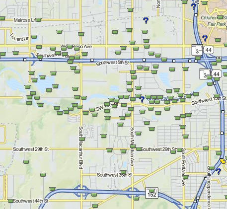
But let’s say you’ve found an interesting area and think it might be suitable for a day out geocaching (in the example shown I’ve selected Oklahoma City, an area I’ve never been and know nothing about). It’s now that we start the hard work.
In practise, if you do this regularly, you’ll have a bunch of locations that are interesting. I tend to keep a note of them and investigate them long before I’m asked. That way I’ve got a good couple of possible locations to geocache long before I’m even asked to work out this week’s plan.
But let’s say I’ve found an interesting area and decided my team are geocaching in Oklahoma City this coming weekend. The next thing I will do is zoom in and take a look at it. Sometimes what might initially look like a good plan may prove otherwise. Sometimes there’s a natural obstacle in the way such as a railroad track or a river, or that shortcut between two geocaches doesn’t actually have a road, only a ravine. Nature can be cruel, town planners can be even crueller.
If after my initial look I still think it’s a likely candidate, I may check one or two geocaches to make sure they are a suitable difficulty for the group or especially if they are near a river, that there’s not been a recent flood that’s made the geocaches unreachable, or even worse, washed them all away. But if nothing jumps out from a quick look at a couple of them, you want to change the view to satellite view.
Switch to satellite view
I will usually do this in Google Maps itself rather than from within the Geocaching website as I like to switch between satellite and street view.
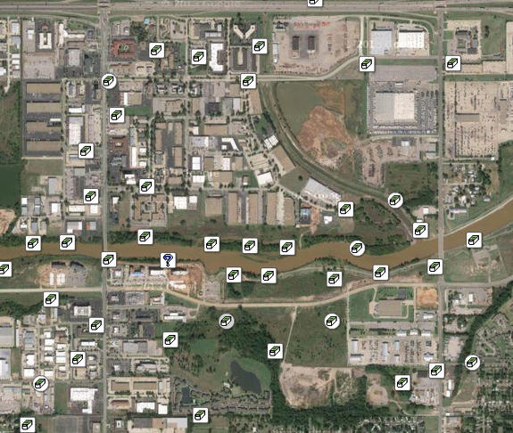
Checking the caches using satellite view
What I am looking for is any obstacles not shown on the standard map that would stop us getting from one geocache to the next. It’s never foolproof – that’s part of the risk of building your own custom circuit for the day – but satellite view often shows up trails and even occasionally geocacher’s paths.
For example, in my Oklahoma example the map shows a trail of possible geocaches along the river between two bridges. But closer inspection shows it’s not necessarily straightforward to get from river bank onto the bridge. There might not even be a sidewalk over the bridge.
Using StreetView
This is where things like Google Streetview can help. I use it to find suitable places to park down little English country lanes or to check trails can be accessed from the road. I recently had to scrap one plan as I found because, despite what the map said, someone had built over a footpath and to get the five hundred feet from one geocache to the next meant a detour of two miles.
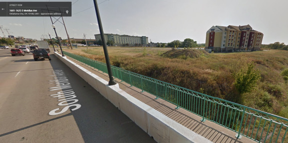
Checking for access issues with StreetView
Maps like OpenStreetMap (or Ordnance Survey in the UK) can also help you spot trails and footpaths, and I use them all in combination to be as certain as I can that my proposed route exists. If you’re doing drive-bys you might want to check Google Streetview to check whether roads are paved or little more than dirt tracks. Sometimes simple things like the amount of pictures of other cars on Streetview can give an indication as to how busy the road might be.
Other criteria
As I go round checking my proposed route I might find that it alters slightly and that geocaches I thought too out the way to be included can now be added to the route. My golden rule on foot is that any diversion from the route to get an additional geocache has to be less than 0.2 miles. I nickname those “out and backs” because we’ll nip off the main trail out to get them and then come back. Obviously your rules might differ but I sometimes make use of Google Maps’ custom maps feature to measure the distance. It can be easy to be deceived that the geocaches that you think make a custom power trail are actually spaced a half a mile apart or more.
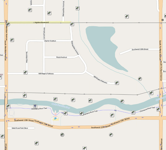
A river runs through it
Eventually, sometimes after an infuriating number of locations that prove unsuitable, you’ll have a potential route. There’s one thing I do before starting to build the GPX file for the rest of the team to put on their GPS devices and that’s to go through at least some of the logs. If I see a large proportion of the geocaches have been repeatedly DNF’ed (Did Not Find), I may abandon my target location for somewhere else. Likewise I’m not going to do a detour of 0.4 miles (0.2 out, 0.2 back) just for a geocache that’s been DNF’ed the last 6 times.
I also look for any of my team’s names in the logs. If we do the odd geocache here or there that others have done then that’s not really too much of an issue but if I find they’ve done a large percentage of the proposed geocaches it’s not going to be a fun day for them and I will change my plan.
I’ll also read the recent logs looking for anything that might cause me to rethink my plan. For example, issues with local muggles, access issues or anything else that could result in us not having a great day out. But if there’s nothing that causes me reason for concern, I’ll then start to build my own custom advanced GPX file and I’ll show you how to build that next time!


Good stuff Adrian. I’m the “cache planner guy” in my groups too! From experience I can say that two of your tips are really crucial for making the most out of your caching day:
1) Checking the Satellite view in gc.com maps
2) Performing a quick scan of recent logs for DNFs or issues
Though the feature on gc.com isn’t really very intuitive, I also occasionally check the “Logbook” and the “Your Friends Logs” to make sure people haven’t already found caches I’m adding to the list.
Looking forward to the next installment!
Thanks Ian.
Hope you enjoy the next part
If you live in the UK you may find my website handy http://www.geocachetrails.com most of the uk series are mapped for you. Sorry about the plug but thought it was appropriate to this posting. Thanks
It’s a great website, Paul. I make regular use of it and would recommend it to people who cache in the UK