UPDATE: Here’s a sixth reason – Garmin BirdsEye Topo.
Still rocking a Garmin 60CSx or maybe an eTrex? Have you wondered what the new units offer? Here are our top reasons to pony up for a new Garmin:
 1. Birds Eye aerial imagery (above right) – This feature is better for those living in open landscapes, like urban areas and portions of the American West. It’ll cost you $29.95 per year, but it can be very helpful. Not so great if you’re always roaming under dense canopy though.
2. Garmin custom maps (above left) – Scan a park PDF map and put it on your Garmin. Or load up some USGS or USFS topo maps. There’s nothing quite like having the same map in your hand and on your device.
3. Advanced track navigation (at right) – This is by far my favorite feature on the new models, and is a boon to hikers, mountain bikers and anyone else following a trail. For years, we could display a track on our screens, but if we wanted to navigate to waypoints along the  track, we were given “as the crow flies distances.” No more. With the advanced track navigation features you get the exact mileage to each waypoint. And it automatically creates a route with any waypoints along the track. Add this to the ability to download tracks for about any trail in the country and you’ve nearly got a revolution in backcountry navigation.
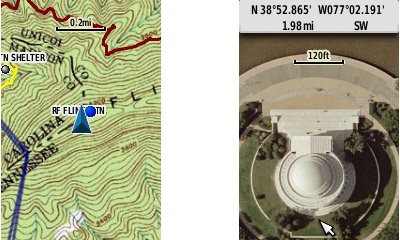
4. Paperless geocaching (at left) – If you’re a geocacher more than a hiker, this is a killer feature. No more printing out details for a batch of caches. Just transfer a pocket query to the device and go. You’ll have the description, ratings, hint and recent logs for every cache you load.
5. Profiles (below right) – This feature lets you easily switch a whole batch of settings (page order,  track up/north, dashboards, etc.) at once. Change from geocaching settings to backcountry navigation, or from topo maps to aerial photos, with ease. Sun/shade profiles are popular for the Oregon series.
Which one to buy?
Of all the units out there now, our two favorites are the Garmin GPSMAP 62s and Oregon 450. Can’t decide? Here’s the pros and cons of going one way or the other.
A question for our readers
Do you own one of the newer Garmins with these features? If so, which are your favorites?


Another feature that is a big plus for Hikers is the ability to view the elevation profile of the remaining distance to your destination. What’s more is you can set this elevation plot as your dashboard on the “Trip Computer” screen or “Map” screen. You will need a mapset that contains a terrain shading Digital Elevation Model (DEM) and currently Garmin Topo maps are the only ones that contain it (Topo U.S. 2008 and Topo 24K series).
I’m no big fan of false summits and with this feature I can see exactly how much elevation I have to gain to reach the top!
Yes. I find myself using this feature quite a bit.Very helpful.
What about the software that helps plan the trip? This has been the reason why I’ve been sticking with Delorme.
For every one person that loves the DeLorme software I’m betting there are many more who dislike it! I’m curious what features you find lacking in MapSource or BaseCamp.
While i only use Garmin here at work (Naval SPecial Warfare), i find Basecamp…SUPER SLOW…and i have some of the fastest computers out there.
Its gotten better, but I agree… slow as molasses!
I am new to Basecamp. One feature that I find missing is the ability to print a single page. Most every program allows one to select the ‘current page’ or to specify the specific page number(s) to print. Not so with Basecamp. For example, I can not print just the page showing the elevation profile, which is page 2. (I have found a way around this but it is an ugly workaround). Also it would be nice if I was able to ‘copy’ the elevation profile to the ‘clipboard’ in order to ‘paste’ it into a Microsoft Word document. If anyone knows a workaround other than ‘print screen,’ please post it.
Hmm, there may be some free screen capture programs for Windows, that allow you to grab just a portion of the screen.
If you are using a modern version of MS Word you can insert screen captures easily.
Go to the Insert tab. (where you can insert pictures, shapes,etc)
Choose Screenshot. There are several sub options
You can either pick any other open Window, or choose “Screen Clipping” to hand select (by dragging) any portion of the window behind Word (e.g. just the Elev Profile in BaseCamp)
http://office.microsoft.com/en-us/word-help/insert-a-screenshot-or-screen-clipping-HA010355185.aspx
Wireless Transfer – The new Garmin units can send and receive waypoints, routes, tracks, and geocaches wirelessly between units. At first blush this feature seems like it would be just another bell or whistle and not a feature of great value. To the contrary I have found this feature extremely handy when needed and was suprised at just how often I do use it.
Examples (very specific but illustrates the possibilities):
1) Out geocaching and one of my friends missed downloading cache coordinates. Instead of skipping the cache or looking for it solo I can send it to my buddy wirelessly.
2) Surveying amphibians I happen upon a breeding pond I want my crew to survey later. I can save the waypoint and back at basecamp I send it to the crewmembers going out the next day. Not only can I send the waypoint but I can send my tracklog so they know a good route on how to get there.
3) Search and rescue. Recording tracklogs during a day of searching, our crew can transfer tracklogs to other rescuers. Once transferred you can enable all tracks to show on the screen. This allows everyone to see search coverage and is helpful in identifying any major holes in the search area that should be covered in the future.
I never used the wireless transfer feature on my Oregon 550t until this past weekend on a hunting trip in the New York Adirondak Mountains. A Friend uses another Garmin GPS quite extensively. I asked him if he happened to have coordinates to a particular area stored in his unit. He said he would share them and began writing. I remembered the wireless feature and suggested we try it. The coordinates actually transferred and began working right away on my Topo 100k Map. It reminded me a little of using downloaded Geocache settings. Nice feature when you need it.
It sure is!
I have an Oregon 550. Primary use is Geocaching, plus it has a wherigo player in it.
And the batteries last longer than my iPhone battery, and when they do go out, they’re regular AA batteries. I use it for road navigation as well, I have lifetime maps.
And the geotagging camera built in is great too. The three-axis compass is an excellent feature.
I kept my 60Cx though, as a spare.
Thanks folks. These are great additions. Keep ’em coming!
I find the Oregon 550 to be a good GPS. All of the observations made by the previous poster I agree with. I don’t find it to be as accurate as my 60cs. The 60 cs was one of my first GPS and is still my standby model.
But I do love the camera, wireless sharing, geotagging photos, All all it is a great GPS.
I have heard several arguments against the 62 From a friend who owns one.
Personally I’ll stick with what I have.
The City Explorer features are nice if your outdoor unit does double duty when traveling, too.
For those fitness buffs out there, your Garmin Oregon, 62/78, Dakota, or Colorado can pull double duty as not only an outdoor GPS but also a training aid. The ability to read a heart rate monitor and record heart rate information in the tracklog is a big plus. Of course you must purchase a Garmin heart rate monitor in addition to the GPS. The fitness profile can be customized very nicely with a dashboard of the stopwatch. Plus, every time you start and stop the stopwatch that segment of your tracklog is specially recorded and labeled “stopwatch(date+time)”. If your looking for a fitness GPS but also need an outdoor unit with all of the above features, the new linup of Garmins is the perfect choice.
I forgot to mention the ability to read the cadence sensor as well. I have never used that feature because I don’t have a cadence sensor but for those of you who do, the new Garmin lineup will detect and read those as well.
Hi yogazoo-
Thanks for bringing up the fitness device compatibility. With all the great reviews that Rich as pulled together here, I’ve been really surprised that this important feature hasn’t surfaced significantly before now. Perhaps Rich and others haven’t listed it partially due to the fact that Garmin themselves seem to hide (or fail to list altogether) the ANT+ feature in their descriptions? Garmin doesn’t list ANT+ support for fitness devices in the descriptions feature lists or specs for handheld nav devices. They do however, give a clue by listing fitness accessories with certain units.
Of course ANT+ compatibility is key for the dedicated Garmin fitness devices. It is covered heavily over at http://www.dcrainmaker.com where the GPS use is heavily fitness focused. I suppose what we are talking about here is more of a hybrid… devices used for navigation and for fitness. Personally, this is a very interesting feature since I hike and bike to explore..and to get exercise…. and I would like to track the intensity of these excursions.
Not all the new units support ANT+. For example, ETrex 10, ETrex 20, Dakota 10, ForeTrex 101, ForeTrex 201, ForeTrex 301 do appear not support this. Since Garmin doesn’t do much to emphasize ANT+ capability with their handheld navigation GPS units, I’ve been working to make my own list. I haven’t tested these… this is just from anecdotal info I’ve gleaned…. so check on it yourself before making a purchase. I think these devices support fitness devices with ANT+:
ForeTrex 401
Dakota 20
ETrex 30
Oregon 450
Oregon 550t
Essentially, it seems that the devices that support wireless data sharing between units also support ANT+ fitness sensors? My guess is that the wireless data sharing must be done using ANT.
Rich, would it be possible/beneficial to add this data to the Garmin handheld GPS comparison chart?
Quite possibly. I’ll put it on my “to do” list, but no promises how soon it will show up since there are literally hundreds of items on it!
I bought an Oregon 450 but quickly switched back to using my 60csx. Tried Birds Eye (resolution not sufficient for my use) and custom map (quad map just added clutter, did not scale well with zoom) – neither proved useful to me. Just a hiker, not geocacher, so wireless transfer & profiles not useful. I can operate 60csx with one hand while moving down the trail, not so with Oregon. And 60csx is much more visible. Going out to buy another 60csx while they are available (at a good price!).
I just updated the software on my garmin oregon 550t i did not follow the directions of moving the GPX folder out of harms way now all of the caches appear as not found, I have taken pictures of the caches as I found them so I have a date, time stamp and location how would I reclassify the ‘Found’ caches to a found status?
Maybe with GSAK?
how to import shapefile to gps model GARMIN OREGON 550
How to import shapefile to our gps modelGARMIN OREGON 550
I think this will do it… http://www.dnr.state.mn.us/mis/gis/tools/arcview/extensions/DNRGarmin/DNRGarmin.html
Otherwise, just search for .shp to .gpx.
If you are going to be converting line files, you may want to go a step further and convert them to a map overlay…
http://www.gpx2img.com/
There are also options to do the latter without the intermediate step of converting them to a .gpx file.
There are issues with DNR Garmin and the new Garmin models (like the Oregon 550) – see the discussion here: http://forums.gpsfiledepot.com/index.php/topic,2494.0.html
To the best of my knowledge, gpx2img cannot read shapefiles, only .gpx files. Depends of what you are trying to do. You might take a look at Mapwel. It can import shapefile and turn them into a full map with custom styles and other features: http://mapwel.eu/
I use Globalmapper myself to work with shapefiles, which is a powerful GIS program but rather expensive. It creates .mp files which are compiled into Garmin maps with cgpsmapper.
Boyd,
Do you know if its possible to use DNR Garmin to convert .shp to .gpx, without using it to send the files to the device?
Is sofware version 3.20 for garmin 62s the most up todate. And or should I leave it alone?
Does the trip computer ever stop? with 60csx I would tell to stop navagating when on a break. Don’t find stop nav with the 62s ?
Thanks
Dan
One more question – Please.
Garmin 62s i want to clear trip data including trip odometer, be save an overall odometer. how do i do that.
Thank Upo
Dan
3.70 is the current version. I’ve seen some elevation gain errors in the last couple versions, so if that’s important to you, you might want to wait for another version to come out and see if they fix it.
If you press Find (while actively navigating), you’ll see a Stop Navigation option. But that won’t stop the trip odometer. They really need a prominent “pause” feature. You can pause it by going to Setup > Tracks > Track Log > Do Not Record.
I don’t know of anyway to do what you asked in your last question, short of saving tracklogs and then manually adding up the mileage later.
Never mind my question about EasyGPS not receiving from 60CSx. The cabel of the 62 does not function on a 60CSx, looks like ti does but, no. When we tried the correct cabel – no problem.
Dan
Strange. The cables are both mini-USB. Were you using a different port?
Rich,
I have two USB ports on my PC. I tried both with no luck. The computer found the device but EasyGPS continually keep reporting no device connected. When I closed that message box, another pops up stating no waypoints in the device. Tried many times and changed USP ports. I then dug out the old 60CSx cabel from the box and was then able to transfer the stored way points to the PC. Changed the cabel to the one that came with the GPSMAP62s and it transfered the waypoints no problem. Why-I don’t know.
Dan
Let me ask about clearing the trip
The odometer isn’t cleared unless you do a master reset. You can go to the Trip Computer > Menu > Reset to reset the Trip Odometer.
New Garmins – I say no to. I’ve had 2 Geko 201s and would buy a third – despite casing failures. New models are not compatible and are SatNavs, not GPS receivers – I don’t want a GPS receiver with any map in it! Also, Garmin use Navteq mapping – it’s considerably worse than TeleAtlas for accuracy (in the UK) but both have been vastly superseded with Google mapping. A GPS or SatNav that I can upload with free Google mapping would be an interesting proposition.
I use the GPS mainly for track record with some object location (so good accuracy is useful) and occasionally for navigation – having designed my own route with waypoints. Computer connectivity is vital too.
Has anyone got any great suggestions of a specific device I should look at?
oh – it’s for hand-held, bicycle mounting and car use!
The only non-mapping units I would recommend are the eTrex 10 and maybe the forthcoming Garmin fenix. Or possibly a Foretrex 301/401. Did you know you can get OS topo maps for the newer Garmin handhelds?
Why do you say the new models aren’t GPS receivers? Because they all have GPS chipsets in them!
If you want Google Maps-based navigation, get an Android smartphone.
What is the comparison Garmin etrex Legend vs Garmin e-trex 10 or 20?? Using for Geocaching?
So many options!! Should i buy a used 60csx at a great price? Get the Garmin glo or elf and get an app to work with my phone/tablet. Upgrade to Garmin GPSMAP 62s and Oregon 450 as this link suggested? One thing i am really confused is with the map download, are they free or very expensive as some suggested? Can i use the 60csx without the need to buy any map, is there a backtrack function on the 60csx.