This is the second in a series of posts designed to help introduce beginners to the use of handheld GPS receivers.
 Routes are used for navigation. As the name implies, they are about where you are going. Routes consist of a series of waypoints, navigated to sequentially in the order you specify.
Most GPS receivers allow you to create a route from waypoints stored on the device. You can also create a route with mapping software and then transfer it to your device. My personal favorite for this task is Garmin MapSource, which allows you to click from waypoint to waypoint to create a route. It’s hard to get any simpler than that!
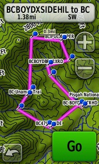
Backcountry GPS routes are generally laid out as the crow flies, giving you the straight line distance to the next waypoint (as seen in the screenshot at left, which shows a loop route). This is a very important point; the route in the image is 4.2 miles in length, while the actual distance on trail is 6.4 miles. Don’t be fooled into thinking your outing is shorter than it will be!
Routes on auto GPS units behave differently, calculating the exact distance, following the twists and turns of roadways. There are a couple of exceptions for backcountry use – Garmin’s 24K series maps and DeLorme’s Topo USA are both capable of trail routing, showing you an estimate of trail mileage. EDIT: A new feature recently added to the Garmin Dakota and Oregon lines allow for this too.
The display fields on most handheld receivers can be customized. Common fields for routes include “distance to next” (the next waypoint in the route) and “distance to destination” (the final waypoint in the route).
The missed waypoint problem
As you move along your route and pass a waypoint, your receiver will automatically start navigating to the next waypoint in the route, displaying the distance to it (assuming your unit is set to display that information). Sometimes, due to an inaccurately placed waypoint or poor satellite reception, you’ll pass right by the waypoint without the GPS recognizing it. The receiver fails to advance to the next waypoint in the route and you start seeing the “distance to next” increase, as you get farther from the waypoint you just passed. Depending upon how the manufacturer handles this problem, it could resolve itself as you approach the next waypoint. Otherwise, you may need to go into the active route and manually select the next waypoint.
Homework: Create a route on your GPS, navigate the route, and look at the options menu for the route.
Routes 201
- The distance between two waypoints along a route is called a leg.
- Most GPS receivers will allow you to reverse a route, handy for out and back trips.
Other posts in this series:


I like reading an article that can make people think. Also, thanks for allowing for me to comment!