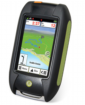
The Rand McNally Foris 850 marks the company’s first entry into the handheld GPS market. It appears to use the same hardware as the Falk Lux 22 which came out in Europe earlier this year. Let’s take a look and see how it holds up to scrutiny…
Quick links
More Rand McNally Foris 850 reviews
Rand McNally Foris 850 resources
How much does it cost?
Hardware
The Foris 850 feels sturdy in hand, although at 8.1 ounces (with batteries) it’s slightly heavier than the Garmin GPSMAP 62s (7.7 oz.) or the Oregon 600 (7.2 ounces). While we’re comparing them, here’s a photo of the Foris and several recent Garmin models…
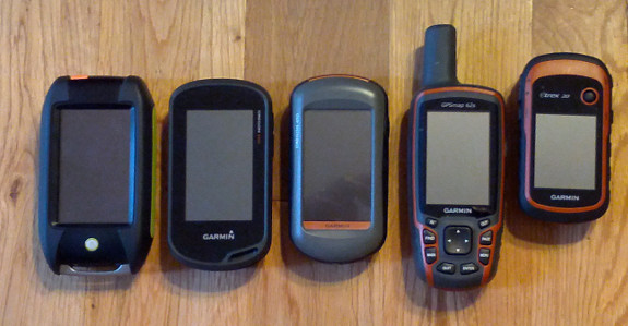
Left to right: Rand McNally Foris 850, followed by the Garmin Oregon 600, Oregon 450, GPSMAP 62s and eTrex 20
The 3″ screen carries a 240 x 400 pixel resolution, identical to the specs for the Garmin Oregon 450.
In the image above, you can see a rail on the bottom for attaching a lanyard.
Below, you can see the orange power button on top of the unit and two buttons on the side. Tapping the power button brings up the following options: screen lock, switching off the display (to save power), stand-by and power off. The top button on the side gives quick access to volume and brightness adjustments, while the bottom one can be set to mark a waypoint or to toggle track recording (on/pause).

The touchscreen Foris 850’s three buttons
Here are a couple of shots of the rear and the battery compartment…
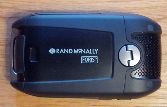
Rand McNally Foris 850 rear view
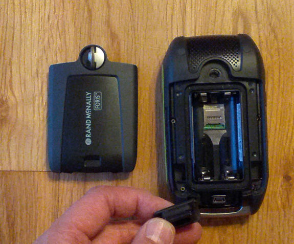
Battery compartment and USB port
Novel features
Trails
It’s nice to see a handheld GPS come preloaded not only with maps but with routable trails as well, including ones from national and state parks, national forests and the Rails-to-Trails Conservancy. Unfortunately coverage was a bit spotty in the national forest areas where I did my testing, but it seems better in the national parks I checked.
Loop routing
Probably the most novel feature on the Foris 850 is the Loop Me routing option that creates a loop route based on the preloaded trail database mentioned above. See the screenshot below at left from the Great Smoky Mountains National Park.

Loop routing, alternative routes with elevation profile, alternative routes
Alternate routes
The Foris also allows you to choose from multiple routes, with elevation cross sections, as shown in the screenshots above.
Voice guidance
The Foris includes road maps too and offers turn-by-turn guidance. Note however that it is not designed as an auto navigation device. Navigation modes are limited to bicycle and pedestrian. I consider this a bit superfluous; I sure don’t want to hear turn-by-turn directions on the trail!
Bike mount
A bike mount comes with the Foris, which is a nice extra. You can see it in the picture below next to some Garmin mounts on my mountain bike. I found it bulky and the installation was a bit awkward, but it does work and I was able to get it reasonably tight without too much effort. Even so, I have to wonder if the fabric tightener isn’t subject to stretching, as I found myself having to retighten it a couple of times during a month of testing.
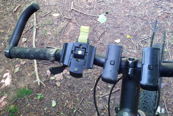
The included Foris bike mount on my handlebars (the left-most mount)
The good
- Displays alternative routes and elevation profiles
- Loop routing feature
- Preloaded maps and trails
- Included bike mount
- Electronic compass and barometric altimeter
- Paperless geocaching
- Can easily pause track recording from map screen
The bad
- Slow to startup (about 50 seconds)
- I was never able to successfully calibrate the compass (see images below)
- Interface feels rudimentary
- Did not auto-detect my time zone
- No GLONASS support
- Contour maps are equivalent to 1:100K scale; no 24K maps available, nor is aerial imagery available
- Trailhead companion software is Windows only
- Failed to load pocket query using drag and drop between folders in mass storage mode; I had to use Trailhead software to load a geocache file
- Does not automatically start track recording
- No settings for changing the frequency of track point recording
- Data field labels can be incomplete (e.g., elevation data field is labelled “ft”)
- No explicit trackback functionality (very convoluted process for doing this)
- Display a bit difficult to read in bright sunlight
- Limited trail coverage
- Limited geographic POI database
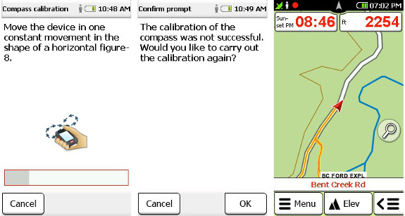
Compass calibration and map with data fields
Conclusion
I’ll give Rand McNally (or Falk?) credit for the novel loop routing and alternative route features. Where trail coverage is good, it’s a nice feature, although I tend to do my trip planning ahead of time and not rely on my GPS to choose a route.
On the other hand, the long list of things I didn’t like leaves me unimpressed. To be fair, it’s always hard to review a new platform. It can be difficult to distinguish between having to learn a new interface and usability issues. So I’ve tried to focus my review more on things that aren’t impacted by that.
At the end of the day, I’m not sure why anyone would spend $399.99 (MSRP) on this unless they had horrible experiences with Garmin, Magellan AND Lowrance devices. I say stay away from it.
More Rand McNally Foris 850 reviews
It looks like I’m the first to post a review of the Foris, but I’ll update this and link to other reviews as they start to show up online.
Other Rand McNally Foris 850 resources
- The Rand McNally Foris 850 owners manual
- A set of Foris 850 FAQs
- The official Foris 850 web page
Compare prices on the Rand McNally Foris 850 at these merchants:
- Check the current Rand McNally Foris 850
price at Amazon


Nice review Rich, haven’t seen any discussion of this device elsewhere. It’s always good to have one more choice for handhelds; keeps the other companies on their toes. But if you’re the new kid in town, seems like you need a lower price point.
But I’d guess this one may be headed for the same fate as the Lowrance Endura and Bushnell Onynx.
And the SatMap!… http://gpstracklog.com/2011/02/satmap-active-10-trek-review.html
I know it never caught on in the US, but isn’t the SatMap popular in Europe?
Yes, but for the life of me, I can’t figure out why.
Haha 🙂 Perhaps it has to do with the fact that it uses raster based maps? For example, I know the OS maps are popular in the UK but Garmin didn’t add raster support until a few years ago. In fact, I think Garmin’s first raster based product was their Discoverer series of OS maps for the Oregon. OziExplorer is also raster-based and has also been popular overseas, but no so much in the US.
Sorry, I guess this is getting pretty far off-topic for the Foris Review. So, to make it relevant… it’s too bad that the Foris doesn’t appear to support raster imagery. That is a major omission in today’s market.
Did you get the impression that this unit is running Windows CE? Linux?
I think you are spot on about raster OS maps. I’m still surprised it has an average 4 star review on Amazon UK though. Maybe I’m more critical than the Brits!
I’m not sure what all the giveaways are on Win CE but I’m betting it is, partially due to a cryptic bar that appeared on the bottom of the screen during bootup.