Having a bad satellite day?
You may not realize it, but GPS accuracy varies from day to day. Satellites occasionally go on the fritz, but the biggest issue is the arrangement of the constellation relative to your position.
You see, GPS satellites aren’t in geosynchronous or geostationary orbits, but are instead in medium earth orbit (MEO), giving them an orbital period of 12 hours. GLONASS and Galileo use similar MEOs. You can see these in the chart below:
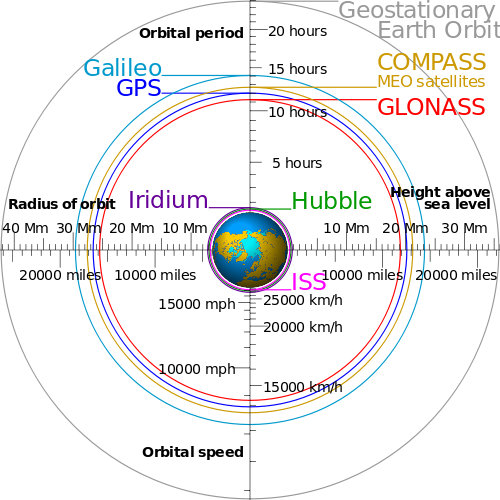
Comparing navigation satellite orbits; image via Wikimedia Commons
Good days and bad days
What this means is that the constellation is always changing relative to your position on the face of the earth, as can be seen in the graphic below and to the right. Note the changing number of visible satellites.
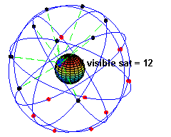
GPS satellite coverage animation; via Wikimedia Commons
This impacts not only surveyors and high-precision users, but others who want the best accuracy, be it for mapping trails, marking boundary lines, hiding geocaches etc.
Consumer-grade GPS won’t give you the accuracy of post-processing equipment, but you should be able to get accuracy of 10-30 feet, IF you choose a good satellite day (and time of day, which is important too). Which brings us to…
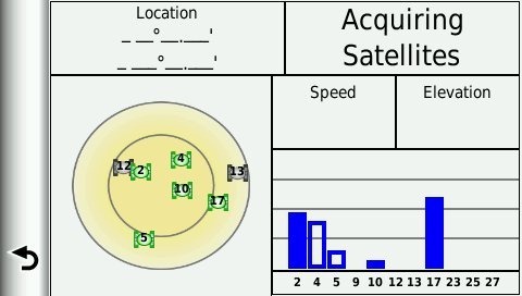
Satellite prediction tools
There are a number of tools available online to predict good satellite days and times of day. This CalSky satellite prediction tool is one that worked well for me in researching this post.
CalSky GPS/GLONASS satellite prediction tool
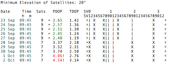
It allows you to choose whether to show GPS and/or GLONASS coverage and specify the minimum elevation of satellites in degrees above the horizon. In the chart below, the bars (|) and X’s indicate visible satellites. The PDOP is also given, with lower numbers being better.


Interesting, I was just researching/reading the very pages you gathered that information from myself! The Satellite prediction page I was not aware of, so many thanks for providing the useful link!
Great minds think alike! 🙂
Useful indeed, thank!
Especially interesting to me is the difference between using GLONASS or not. The extra satellites do make big difference in PDOP.
GLONASS can make a huge difference…. Just not the difference everyone hoped for:
https://forum.garmin.de/showthread.php?20517-Oregon-6×0-GPS-Empfang&p=151510#post151510
I suspect these are firmware issues which can be fixed.
I also suspect firmware updates can resolve these issues. If Garmin stay true to form, the Oregon 6xx is due for another update some time this week.
A visual example of potential GLONASS induced error:
http://garminoregon6xx.wikispaces.com/file/view/Bug%2029%20Example%203.gif/453619220/Bug%2029%20Example%203.gif
Ouch!
Hey, mind if I use that image in my link roundup this weekend? Maybe it will get someone’s attention in Olathe!
OK with me!
I should point out those tracks are from a single user, and GLONASS does not always have that affect, though I have seen multiple threads in several forums were Oregon 6xx users report better accuracy from their Oregon 6xx with GLONASS disabled.
I still recommend only using GLONASS when GPS accuracy is not acceptable, until firmware improvements are made.
That German thread and the picture AtlasCached posted are the first I’ve ever hear of this problem. I’ve not had this issue on my eTrex 20.
Is it limited to the Oregon? Is it widespread, and frequently observable?
I do not have an etrex, so I can not test one, but many Oregon 6xx users have reported unfavorable GPS accuracy.
http://garminoregon6xx.wikispaces.com/share/view/62732426
Yeah, I seem to recall multiple reports on Groundspeak too.
Guess that’s why I never buy version 1.0 of anything. I misread your original remarks as if you were saying GLONASS itself was a problem generally, rather than a specific GPS model having a problem with it.
Re-iterating, I have an eTrex 20 and having GLONASS active usually improves accuracy; never diminishes it that I can tell.
I primarily use a Garmin Montana 650t. My backup gps is an Etrex20. Although my Montana is very accurate, I find the etrex is more accurate, and I can only attribute that to Glonass. I use the etrex when hiding caches.
Just my experience.
Thanks for the great site.