UPDATE: Read our hands on review of the Garmin Monterra.
I’ve had the new Android-based Garmin Monterra for a few days now and have been playing around with it a bit, so I thought I’d share a few screenshots.
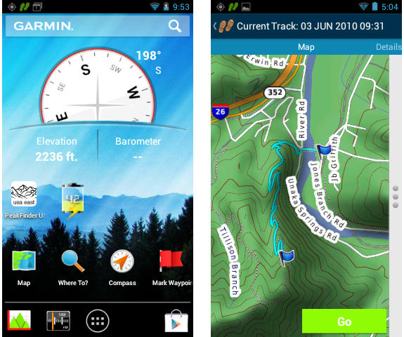
You can see the home screen and a map of a track above. Interestingly, all the Garmin tools we’re familiar with are now individual apps (see screenshot at left below). I’m still trying to wrap my head around the implications of that. Imagine being able to download your choice of these to your phone! Not that I’m expecting that to be possible; not anytime soon anyway.
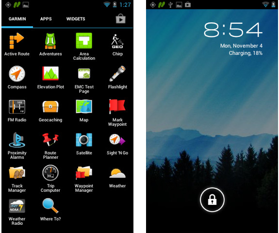
Monterra’s Garmin apps tab and lock screen
Another interesting feature is shown below. Pull down the notification tray and you can pause track recording.
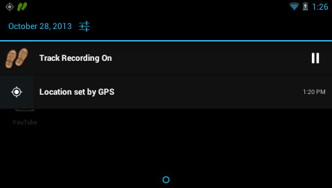
Track recording can be paused from the notification tray
Here’s a couple of screenshots from the tracks app, where you can slide between the map and the two screens shown below for any saved tracks.
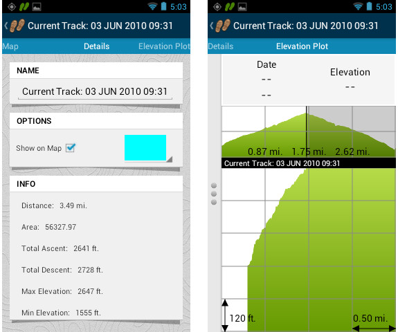
Garmin Monterra saved track screens
Questions about the Monterra?
What do you want to know about the Monterra or see covered in my review? I’ll qualify that by saying that my time is more limited these days and my hands on review may not be quite as detailed as past ones. Nevertheless, let me know what you want to see and I’ll work in as much as I can.
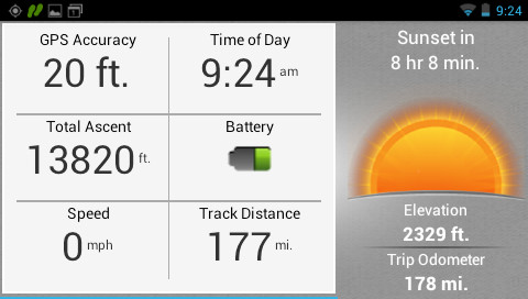
Garmin Monterra trip computer


Google Play Store support?
They obviously have the Play Store on your review unit (as promised), but have you been able to test any downloaded apps? Do apps like Navigon even show as options? Have you tried any of the Geocaching apps to see if they’ll load and/or work?
And to follow up on Darryl which is related to what I was going to ask… if the apps (such as Cachesense, Neongeo, etc.) do download, how well does the display look? Definitely looking forward to screen shots of these type of apps in use.
Thanks for wetting my appetite, and draining my wallet… 😉
Navigon shows as an option, but I’m not sure I’ll test it. Can you suggest any (ideally free) geocaching apps for me to try that allow for offline use.
Neongeo and Cachesense both have demo versions. Bruce (Cachesense) might be able to give some other options as well, as having an app like this on the GPS would be good for him. You can download caches while connected to wifi, then go out in the field and hunt. C:Geo is free, but I think you need the live connection, and since it’s frowned on by Groundspeak (and a lot of cachers) I wouldn’t really recommend it.
C:Geo is the main one used by android folks, and will be one most asked about. Free, and it has been bought into the fold by Groundspeak last year ( http://firennice.squarespace.com/journal/2012/2/23/groundspeak-responds-about-cgeo.html )
This is mostly in reply to rob, but there was no “reply” button under him.
C:Geo has not been brought into the Groundspeak fold. They have refused to play with the API and so are scraping the site to get their info.
Because they do not use the API, when there is a change to the website it can go down. They have to rewrite how they scrape the site, and then get the out in the market again. I used it a few times, but when I was stuck 60 miles from home, and it was not working for two days, I loaded another app.
I know they don’t use the API and it’s up to them to rewrite each time, but the post by Bryan sure suggests they aren’t in the doghouse as much as they were before. That was my main point.
Yes, it does have Google Play store support.
Would you please review how maps are managed, if all types of maps supported by the Oregon/Montana line can be used and active at the same time (img vector topo or road maps / kmz custom raster maps / jnx birds eye maps / poi files for alerts and custom waypoints), are this maps combined into a 3d view option?
Does the unit include voice prompts when using street routable maps, a nuvi mode? Does the unit include the active route tool which includes start and end, high and low points when following a track? does the unit allow pairing with garmin ant+ heart rate strap
There is an interesting android app to switch between recent apps that might be useful on the monterra if compatible:
Switchr – Task Switcher
https://play.google.com/store/apps/details?id=mohammad.adib.switchr
Thanks on any information you could gather on this items!
Have not been able to obtain a pre-release Monterra, so my review will have to wait until after I purchase a retail version 🙁
Rich, what is your opinion of the low res (by android standards) screen? How does it look inside and outside (shade and sunlight)?
So far I’m pleased with visibility, but I will be doing some extended field tests later today and should have more feedback after that.
Oh come on! Geocaching..geocaching and more geocaching! Do I need to drive over to Asheville and go caching with you?!
Still looking for a next gen GPS device for caching.
Ha! I would have included geocaching screenshots yesterday but I had trouble with that “app.” I am now off the very early 1.x firmware though and on a 2.x version, so hopefully that issue is gone.
How good is the refresh/redraw? I remember with some units it was painfully slow.
I just used Astro file manger to rename .img map files and have them disappear from and reappear on the map setup menu. A possible way around the tile limit?!
This feature alone may be worth the price of admission.
Can you rename other files, such as KMZ or GPX?
Well, offcourse you can rename files in Android, Astro File Manager is an File Manager app, so every file and extension you can copy, move, rename and delete.
This is one of the big advantages of Android (iOS is much more closed).
The most curious I am about is the integration with Android and how easy I can move around files or data like waypoints, tracks and routes between websites and other android apps.
I am curious about whether this unit functions the same way as the Montana with Profiles and changing Profile automatically when placed in a mount. Also, how much memory on board, are the maps routeable, and which version of Android does it run? Thanks!
Please tell me more about CURRENT TRACK functionality. Is it like the Oregon 650 with a play/pause button. I am scrapping my Oregon 550T due to the bad tracking functionality…
Yes, there is a record/pause button.
Thanks, but none of the available reviews is telling me whether the Monterra’s TRACK interface is exactly like the new Oregon 650 type, or if it is new. On the 650 TRACK you can see how far you have traveled, pause the track, check the area, etc. Very nice summary view in that mode. Everything I see on the TRACK capability for Monterra looks like a drop down set of options instead of a summary of the CURRENT TRACK. Could you please assist by showing a screenshot of the CURRENT TRACK?
To clarify, I guess the screenshot you show above does have that CURRENT TRACK summary data I am looking for but does it have a PAUSE/PLAY button like Oregon 650 on that same screenset?
Yes, it does. And it is also available on any screen via the pull down notification menu.
Does it have a glove-friendly screen like the Montana? This is essential for motorcycle use. I know the screens are technically different. Thanks!
Is there any limitation on GPS signal pass-thru to other GPS apps, like these free ones:
Avenza PDF Maps: https://play.google.com/store/apps/details?id=com.Avenza
Collector for ArcGIS: https://play.google.com/store/apps/details?id=com.esri.arcgis.collector (If you have an ESRI subscription)
OruxMaps: https://play.google.com/store/apps/details?id=com.orux.oruxmaps
Thanks.
The manual is now available download. Nothing super exciting in there though…
The Manual says there is a setting for “Glove Mode” which increases the touch screen sensitivity. This could be a make-or-break feature for me as I’d heard the Monterra didn’t work with gloves (unless they had a special conductive finger tip, as required by most smart phones). Hopefully Rich will be able to test this.
I’d most want to know how this compares to Garmin’s other handhelds all around, especially the Oregon 600 to which it shares most common features. Is this the new top of the line benchmark. Is it crippled by new product limitations and waiting for future updates. Is this the future of the the handheld line or is it destined to be a one off attempt that fails. For years I’ve been watching and hoping Garmin would release the next greatest thing. Each time they come out with something there is always a gotcha. A hardware limitation, bugs galore, whatever. A few years of updates to firmware and they knock the bugs down to a usable level, but never get rid of them. As the years drag by, the difference between the handhelds and automotive units grows larger. It’s pretty alarming to compare the two these days, the handhelds seem down right archaic. Compare it to a modern smartphone and they look even worse. In the end they never seem to deliver a product that is obviously superior to those gone by let alone modern by current standards.
Here’s an in-depth review of the Monterra
http://globeriders.com/article_pages/article06_gps/article06_monterra.shtml
I have tested the Oregon 600 under a dripping water crane and that is not a complete success. It goes better when the Oregon is set to normal touch sensitivity and not high sensitivity.
But what happens then when I wear thin gloves? For gloves I need high sensitivity setting.
How does the Monterra works with this? Standing in the rain and wearing cloves?
Pausing the current track does not seem to pause the trip computer. Is this standard operating procedure for Garmin? When I view the details of my track in Basecamp I’m noticing the spots where I paused are still logged in the trip computer throwing off overall stats like average MPH, etc. I can see an argument for why the trip computer should continue click on for accuracy but I can also see a compelling argument for why it should be paused when the track is paused.
Am I missing something?
Well, maybe…Garmin’s Trip Computer shows actual data. Garmin added a new Data Field this year call Track Distance which will follow the actual Track Log (Current Track) distance. So if you Pause track recording you will see that this field is not updated until you start recording again.