UPDATE: I’ve posted reviews of the DeLorme Earthmate PN-60w and the PN-60w / SPOT Communicator combo.
UPDATE 2: DeLorme has discontinued the SPOT Satellite Communicator in favor of their own product, the DeLorme inReach, which offers two-way communication and works as a standalone device or can connect with the PN-60w or with the iPhone or Android smartphones.
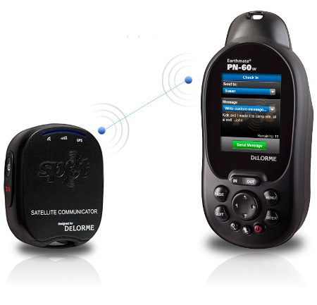
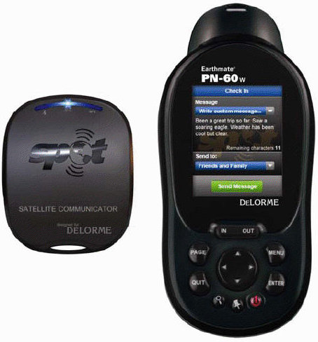
We’ve got some big news for backcountry types today. DeLorme and Spot have jointly unveiled the first combination ruggedized GPS navigator and satellite communicator. The DeLorme Earthmate PN-60w with SPOT Satellite Communicator can send customized text messages to individuals or groups. While emergency messaging or personal locator beacon capability is something I’ve been wanting to see in a handheld GPS receiver for awhile, plans are for the PN-60w to offer even more.
Lets back up a bit first though. As you can see from the image above, these are two separate units. We’ve been told that the devices will connect using a yet to be disclosed wireless protocol (hence the “w” in the model name). It’s described as having an ultra-low power draw and a range of over half a mile in recent tests.
But get this…DeLorme plans to release a firmware update in the fall that will allow communication between PN-60w devices, allowing users to see each other on the map, send text messages, and share waypoints, tracks, and routes. This is a very interesting combination that goes beyond what Garmin’s Rino series offers. With the PN-60w, if you get out of range, you can use satellite based communication to compose and send text messages to predetermined individuals or groups.
Speaking of which, according to the news release, messages can also be shared with social networking sites like SPOTadventures.com, Geocaching.com, Twitter, and Facebook.
Like the SPOT Satellite Messenger, this data is sent via satellite, and doesn’t rely on cellular networks, which makes it such a useful (and potentially life-saving) backcountry tool. The SPOT Satellite Communicator also has stand-alone capability to send location-based SOS notifications to an emergency response center.
SPOT has created a unique product and has lots of fans, but it hasn’t always been a smooth ride for them. Last month, they announced a recall of their second generation Messenger product. The false security provided by the devices has also led to people being less than fully prepared for the backcountry, and has significantly increased the number of calls received by search and rescue (SAR) agencies, who are the ones having to deal with the fallout from this technology. How ironic it will be if the PN-60w’s capabilities make it the unit of choice for SAR!
The PN-60w is slated to be available in the spring of 2010 – May appears to be the target date. Unit and service plan pricing was not available at post time, but we can tell you this — owners will need to have a SPOT subscription and then add a text message option to the plan.
More DeLorme news
- There will also be a PN-60 for users who don’t need wireless capabilities; PN-60 series improvements over the PN-40 include better battery performance and 3.5 GB of internal memory
- DeLorme will also be unveiling “new worldwide map data for the PN-60w” this week, including high-resolution color aerial imagery
- Topo USA 9.0 will be released in conjunction with the PN-60 series, and will include interface improvements, such as a new Exchange Dialog


Just curious – why not create a 2800 mah CR-V3 Li-ion battery for the PN40 vs the 1400mah?
Very interesting product…So I won’t have to chew my arm off if trapped under a boulder? Someone WILL come to rescue me! Hoorah! (-:
I am looking forward to this one! I have been using gps for 10+ years & SPOT for 4 – it’s great to see them (finally!) being linked together.
IMO, Delorme has really taken the lead away from Garmin in handheld gps innovations.
Hopefully Delorme takes it up another notch soon & builds an All-In-One model (GPS,XM,SPOT)
I’m an older guy with a lifetime of high tech experience, was chief engineer for a major aerospace company satellite division before retirement. Was happy to see the spot communicator option so bought the 60w se plus spot communicator for next week’s Sierra 7-day backpack. It is a good feeling that help is there when the heart attack hits-even though I haven’t had one in 50 years of hiking. Was disappointed when the pn60w se arrived with merely a promise to send a spot device – some day with free postage – whoopee! but I already paid for the ensemble and paid premium postage to get it in time for my trip!!!!!
The 60 has a small screen compared to my Garmin’s, it has some nice features too but I’m here to talk about shortfalls. The screen redraws quickly, but it should being so small. The 3 axis compass is a dud: after multiple calibrations it is 10-20 degrees off, with the error not constant around the rose (errors are 15 deg east of N and 10 deg east of S, so it’s not a bias but rather a symptom of a poor compensation process. The first set of batteries (fresh alkalines) lasted less than 8 hours, power saving mode was activated too. The jury is out on their netlink maps: Ordered a small set of maps/pix yesterday for internet delivery but no sign of them yet. The instructions are vague on exactly how I will be informed about map readiness. The track log only has a time or distance recording criteria, guess I was spoiled by Garmin’s automatic scheme that made the most of memory and didn’t miss turn details. The 60 has a very good distance measuring scheme: better than Garmin 60cs, and far, far better than the Colorado/Oregon approach. Still haven’t been successful at navigating to an address, or even finding a specific address, the interface is clumsy at best. A test route to a waypoint took me through a barricaded street (been that way for 40 years) then through (an inaccessible to muggles) gated community. Searching for waypoints is equally arcane, or maybe it’s easy and the manual is deficient. Trying the spot menu, albeit without the spot unit in place, got a message that I needed the spot device and a firmware upgrade for the 60 to boot! Strange about the 60 firmware upgrade, this shouldn’t be needed out-of-the-box, did they forget to do beta testing? The manual says that when I use the TOPO program and execute the ‘sync’ function a firmware upgrade will be automatic. I have run the program and didn’t get an offer to upgrade firmware; one of these messages is wrong. If the ordered maps (1:24000 scale) aren’t available by the time of departure for the Sierras, the PN60 will stay at home, it isn’t worth it’s weight and batteries if it only has 1:100,000 maps. A spot-check of the latter in the Kearsarge/Glen Pass area is missing several trails that have been there for years! More to come.
Does anyone out there have experience with ‘netlink’ and its delivery time/method??
Changing platforms is hard!
Thanks for sharing your thoughts; looking forward to hearing more. I only have a couple of other comments…
As I recall from testing the PN-40, delivery of maps was relatively quick (10 minutes at most?).
Were your compass tests by any chance done around large metal objects (e.g., cars)?
I changed platforms because of my disgust with Garmin’s ‘Nuvi-fication’ of the gold standard 60csx platform into the Colorado/Oregon abomination. I really want the pn-60 to work and am trying hard to like it. Maybe Delorme should provide a ‘Garmin to Delorme’ conversion guide the same way another company provided a ‘PS to Mac’ conversion aid!! This would include a waypoint icon converter. It will take many hours of work flip thousands of garmin icon names to Delorme icon names.
Just returned from backpack adventure in the Sierras, didn’t take the pn60 on the trail because of its battery life problem and because the requested (and paid for) maps didn’t arrive. Did use it in the car going and coming. I have started to like it a bit more based on the car (including some off-roading) experience. Nice bright, albeit dinky, screen; good detail; great distance measuring scheme; and good dirt road (trail) info.
I have had not had much success in using the ‘find’ function. I must have some fundamental misunderstanding on that feature, Delorme’s exhortation to use its Wiki pages hasn’t helped.
Delorme’s tech support recommendations on battery life were: ‘use Power Saving mode and use the option to ‘Sleep when Stationary’. I had already done that at initial turn-on; also they suggested that I only use the map page when needed, a major PITA when on the trail; that’s too much fussing!……… If it takes that much TLC to meet their advertised battery life, said conditions should be stated in their spec sheet!
As for the compass calibration, there was no metal within 50 ft of the unit. I even removed the calibrating manual compass from the area, having laid out a compass rose ahead of time and double checking with Polaris later. I have calibrated many compasses and know the drill. There is something wrong with this pn-60 feature!
Delorme tech assistance guy sent me the instructions to reset compass function; the compass now works fine, within 1 degree of my standard rose. 🙂 they also provided direct access to firmware update package, I now have latest stuff installed. 🙂 But still no SPOT device. 🙁 I am performing a retest of battery life; between the compass fix and firmware update, the battery life seems to have improved? More later as testing progresses. Haven’t solved the map delivery issue yet. Still haven’t succeeded in navigating to a street address though.
Their tech assistance is superb; it is like Garmin used to be!!
For someone that owns an early GPS by Garmin that is a large green monster with black and white screen, disregard pricing for now…..Is this too much tech for me to begin Geo-caching hobby? My other use will be to navigate my way home when I get lost on Lake Wilie, SC on my yet-unowned boat navigating the labrynth of coves and shorelines before running out of gas? I have backpacked over 2K in the Sierras over the last 40 years with nothing more than a topo map. I do not have the physical ability to hit the back country any longer, so I do not need this toy for that.
Thank you all for giving thought to this for me.
Unless you really need the satellite communication ability, this is overkill. There are a lot more user friendly units out there. Maybe a Garmin Oregon 450 or GPSMAP 78s.