 Late last year, Garmin rolled out new track navigation features for the Dakota and Oregon lines; these capabilities are also being rolled into the new 78 (and presumably 62) series. So let’s take a look at how it works and some ways to get the most out of it.
Basically, it allows you to follow a track, giving you an accurate estimate of remaining mileage, instead of the “as-the-crow-flies” distances typically associated with routes. IMHO, this is one of the nicest features added to handheld units in recent years.
On the Oregon series, just select Where To? > Track and then select the track you wish to navigate. The highest and lowest elevation points, along with any of your waypoints along the track, are used to create a route.
Getting tracks
If your trek takes you into terrain you’ve never explored before, try searching the Web for a track posted by someone who has already been there. My favorite search terms are the trail or park name plus .gpx. There are a ton of track sharing sites out there to check too, such as Garmin Connect and EveryTrail. UPDATE: Here’s a whole post on this subject.
Track navigation tips
This is a relatively new feature, and it can sometimes seem a little rough around the edges. Here are some tips to help you make the most of it:

- The direction of navigation is dependent upon the track. Even so, it doesn’t always seem to work out. If you find that it’s navigating in reverse order, go into Track Manager and select the track you want to navigate, then choose Copy Reversed. It will prepend an exclamation point to the track name (though you can rename it yourself if you wish). Then start navigating the reversed track.
- If you’re going on an out and back trip, at the turn around point choose Where To? > Track > Current Track > Tracback. It may take a short distance for it to start showing the correct mileage and next waypoint, but it should work.
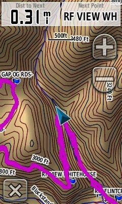
- You may find it helpful to use some of the following data fields: Distance to next (waypoint), Waypoint (name) at next, and Distance to (final) destination. You can see examples of the first two in the top screenshot.
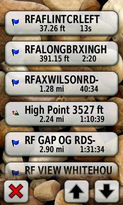
- You can check the order of waypoints on the Active Route screen (seen at right).
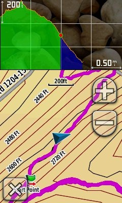
- Try out the elevation dashboard (seen below). This shows your elevation history on the left in green, with remaining track elevation change on the right in blue. On the Oregon, access this via Setup > Map > Data Fields > Dashboard > Elevation Plot.
- UPDATE: You can insert a waypoint into a track you are already navigating by creating it on the map. Tap the map, fine tune the location (make sure it is along the track), tap the top info box and then the mark waypoint icon.
 Enjoy! I’d love to hear what you think about this feature, along with any suggestions for Garmin to improve it.

A bit confused (age thing I guess) – is this ONLY relating to tracks or are routes similarly treated – alternatively if I created a route in say Memory Map & converted it to a track would that work?
I’m not that familiar with Memory Map. Do their routes follow the trail or are they “as the crow flies, straight line navigation?
This is a fantastic feature for people who go off roading in jeeps etc, where there are no marked roads. You can create a track on Basecamp to follow the off roading and follow it as if it were a route. Fantastic!
Thanks for the good info Rich! I am a recent buyer of etrex 30. I am trying to understand how I can measure distances between the waypoints I create while hiking. For example, let’s say I am doing an out-and-back, I set a waypoint at the last known water source and I want to remain aware of how far I have traveled from that waypoint—on the route I am currently creating, not “as the crow flies.” I cannot seem to find a way to do that with the etrex 30, but given that is has the newer technologies perhaps I am just missing something? Thanks for any help. Greg
I don’t think there is any way to do it without navigating to it, but you should be able to do it using Trackback (navigating the current track)…
http://gpstracklog.com/2010/07/navigating-tracks-on-the-new-garmin-handhelds.html
Is this feature also included on the new ETrex 20’s and 30’s?
Whoops! Just read your answer on the ETrex 20 review page!
Glad you figured it out!
Hi Rich, thi sfeature is exactly why I got the Oregon 600 as it just came out. BUT I am reallyhaving trouble getting it to measure the distance to the next WAYPOINT. rather than waypoints, it is telling me the distance to the next “point” on my track/route. I tried deleting the points I am not interested in, but then it just goes point to point rather than following the actual route we want to travel – which is the San Marcos River by the way. what we are doing is trying to establish a route for the Texas Water Safari river race. there are 10 official checkpoints along the 265 mile race course which starts in San Marcos and ends in the Gulf of Mexico. it would be HUGE if we knew how much farther it was until the next checkpoint. please let me know if you or anyone else can help with this. the actual route with checkpoints is hung as a gpx file on the race page here so you can see what I am working with. http://www.texaswatersafari.org/course-map/
Are you navigating the track (as opposed to a route of waypoints)? Try Where To > Track, and then go to the Active Route. You should be able to see the distance to any waypoints along the track.
GPSMap 62S – Distance to Next would be EXCELLENT, if only it worked. OR, more correctly, if only I could figure it out. Distance to dest(ination) works fine. I put both fields on my map screen. I only keep tracks, waypoints, and maps on the GPS that I am travelling on any day. And, to be clear, tracks, not routes. I’ve created tracks in Basecamp adding waypoints along the tracks for landmarks or navaids. But as I ride the course, the Dest to Next field shows incorrect distances for a distance to the next waypoint. To try to correct this I’ve tried carefully entering the waypoints in sequence along the track as I would reach them on a ride. No difference. AND…how does the GPS “know” the waypoint I just PASSED is not the NEXT waypoint? ie, why would it measure the distance (if it actually worked) to the real next waypoint as opposed to the most recently passed waypoint? I’d love to be able to use this feature.
Mike – I did end up calling Garmin tech support on this and they showed me that if you go into the “waypoint manager” it will correctly display the distance to the next way point in certain models. the Oregon 600 is one of them and I got it to work correctly. BUT then on the same route a couple weeks later during the actual race i was in, it reverted to showing the B-line distance and not the distance along the route. so I will have to do more testing to get this waypoint manager thing down.
John,
Hurry! It’s cruel to keep an idiot in suspense! 8-}
Seriously – THANK you for the speedy reply and additional info. Obviously I can live without it but I would really like to have it working.
Thanks again!
And you are navigating a track? (Where To > Track)
Yes, absolutely. Track Manager>Track (selected)>Show on Map>View Map>Go
(GPSMap 62s)
And this would be a track (not route) I created in Basecamp and sent to the GPS.
All you should need is to be navigating a track and have waypoints along it. The Active Route page is a good way to check whether or not it’s picking up the waypoints. A few things you could try — a different track, making sure your firmware is up to date, and a hard reset (but you’ll lose all your settings).
Hey John, Have you tried setting up the Activity accordingly in your Oregon 600? (Under setup, then routing followed by Activity? If it’s selected to direct routing, it’ll be acting like if you set it up to bird line, if I’m not mistaken.
I’ve got the exact same model and love it so far…
Hi Rich,
Thank you for your prompt response to my previous question at Montana´s review.
Still regarding waypoints position while navigating a track:
Is it only my the think waypoints should stay on top of pink route instead bellow?
Has someone have already requested that to Garmin? I couldn´t find anything about it.
tks
I agree, but it could be that re-layering map features would be pretty complex. Here’s a place to suggest it though: http://www8.garmin.com/contactUs/ideas/
hey guys,
so I used to have the vista and it had a fueature i used aLOT because I used to travel on the river. You could travel on a track to a specific trackpoint that you could randomly select and it would follow the track that I had pre made at home on my computer. I have not been able to figure out how to do this on the new 30. I can either navigate a whole track to the end or nothing. can you navigate to a specific track point. why this is nice is I only have to create one track file and then I can just choose which campsite I feel like travelling to that day ( which may or may not be waypointed) its also handy to determine how far to the next campsite I choose so we can see if its even doable ( river miles are way longer than crow flies miles).
any help would be greatly appreciated