 TOPO Afghanistan
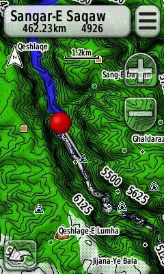
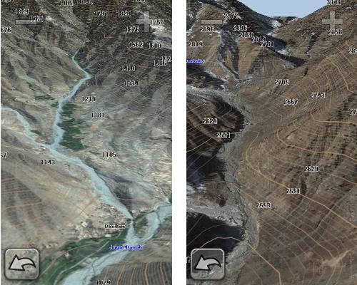
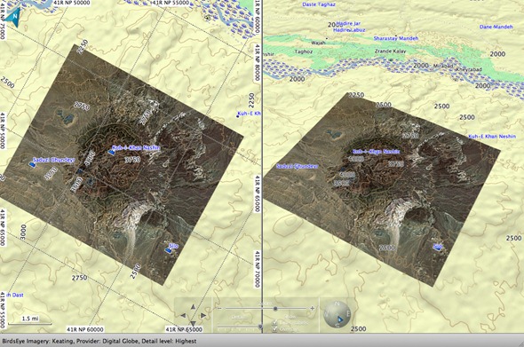
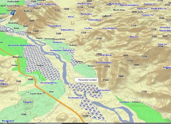
![]() is being announced today by North Hollywood Cartography, an authorized Garmin MPC developer. This is actually the third-generation of the product; the first was released through GPS File Depot. The next iteration included the entire country. The newest version adds a digital elevation model for 3D viewing in BaseCamp and compatible Garmin receivers. Geographic points of interest including wadi (arroyos/dry creek beds), summits, kariz and settlements.
is being announced today by North Hollywood Cartography, an authorized Garmin MPC developer. This is actually the third-generation of the product; the first was released through GPS File Depot. The next iteration included the entire country. The newest version adds a digital elevation model for 3D viewing in BaseCamp and compatible Garmin receivers. Geographic points of interest including wadi (arroyos/dry creek beds), summits, kariz and settlements.
Sales will be through government distributors and to individuals affiliated with the ISAF or other government users.
While there are military issue GPS receivers being used in Afghanistan, I’ve been impressed by the number of comments and questions I’ve heard over the years from troops using their own standard, commercially available handheld units in the field.
Like most specialized mapping software, Topo Afghanistan doesn’t come cheap. List price is $399.96 (USD) for the DVD or pre-programmed microSD card (with SD adapter), though I understand that there will be a 25% off introductory discount that brings it down to $299.97![]() . A $199.98 upgrade is available for registered GEN1 and GEN2 users.
. A $199.98 upgrade is available for registered GEN1 and GEN2 users.
More screenshots…
Provided Images © 2010 North Hollywood Cartography
![]()


I used this software extensively in Afghanistan in OEF IX. I found the maps accurate and reliable, better than the Army published Garmin compatible software. The Army’s version stopped giving detail at certain zoom levels, while TOPO Afhanistan was fine detail at all levels. I found the PC interface through Garmin Mapsource to be just as easy and accurate. A must have for any Infantryman, aviator, engineer, or contractor!
Thanks Brian. Good to hear such positive feedback!
If you move about ASTAN in convoys or troop movements this is a very useful product. Use the waypoints to assist in Nav and Force Pro. I have used this here often and it is a really useful tool.
I used this software in Afghanistan (Gen 2) while deployed with the US Air Force. This map was spot on both on and off base. Definitely an asset to have especially when not everyone can get access to the DoD maps/GPS units. The ability to use this map directly from MapSource and load it to your personal unit is a huge asset. Definitely a great assets; especially with the latest Garmin units that can show 3D on the screen.
GPSFileDepot was proud to host this map and very happy that North Hollywood Catography is able to take it to the next level.
Dan, good to see you here. Your site is awesome! What a great service to Garmin handheld owners.
My son is a young Infantry soldier in Afghanistan. Been there a week and asked me to send him a good handheld GPS w maps of Afghanistan. I’m looking at the Garmin 60CSx,but the maps here are more than the GPS! Not sure how many young soldiers can afford this.
There are free topos available at http://gpsfiledepot.com, but they won’t have all the features of Topo Afghanistan. If I’m not mistaken, Garmin slaps a $10,000 fee on MPC developers. This, and the limited market, is why most third-maps by authorized MPC developers carry such a high price.
I would pass on the 60CSx and get him an GPSMAP62S or newer Oregon model to be able to use all the features this map has to offer. I used a 60CSx with both the GEN1 &GEN2 versions, and it was fine. While on the waiting list for this map for over 6 months, I picked up a DeLorme to see if that would fill the bill, but it fell short with their 250K topo map, so I traded it in for an Oregon 550. Once the GEN3 was offered in presales, I jumped on it. The images provided here don’t do the product much justice, it really is amazing in basecamp with birdseye, you can forget mapsouce. If the price is too much, you can always order the sdcard version and sell it once you return, to recoup your investment. For me, this was money well spent- JD
I need your SD software here in Afgahnistan – Ihave a VISTA HCX – should I upgrade to a 62s
Is there a package deal for a GPS with AFGHAN topo
Larry, I sent a note to the map developer, asking him to respond here. He’ll probably post something later today.
Larry, at this time we only provide the map software. It will work quite well on your Vista HCx, but we recommend the GPSMAP 62s for it’s additional features. I think Rich can help you find a good deal on the GPSMAP 62s. If you get the microSD card, you can move the software to a new GPS yourself easily.
Larry, I’ve seen the 62s for as low as $319, but right now its running closer to $400. You can keep an eye on our deals site, http://bestgpsdeals.net, if you want. If I see anything real good, I’ll be positing it there.
Broke down and purchased the DVD for $300.
I’m heading over later this year, as part of a Provisional Reconstruction Team, and wanted to be prepared.
Overall I’m impressed with the detail of the maps and am looking forward to trying out the Birdseye images with my Garmin 62s. After seeing the maps it puts me more at ease for spending that amount of money. One of the other guys deploying with me is on the fence and now I’m sure this will put him over. He’s bummed that the maps are locked to a specific GPS unit so he’ll have to purchase his own license 🙁
Thanks James. Glad you’re happy with it. Good luck over there and thank you for serving.
I should add, if you get a chance… I’m sure our readers would love to hear about your experience with it from the field.
Thanks for the feedback James. This map is locked, as this feature has been requested by users in the field to secure the data from unauthorized users. If you’ve ever had to do an EMERGENCY ZEROIZE on a DAGR or PLGR, you will appreciate how quickly you can zeroize your Garmin when every second counts.
I am using the software on a 62S – here in Kabul – It rocks – highly recommended for those who travel outside the wire. Get it.
I need to do route planning on a PC and download tot he GARMIN – can the map on the MICROSD card be moved to the PC ?
I *think* you can view the map in BaseCamp with your GPS connected to the computer. No need to remove the microSD. It may take awhile for it to display the first time. I haven’t found a good info source on it, but this may help…
http://garminoregon.wikispaces.com/message/view/home/22369903
You will be able to use preprogrammed datacards with BaseCamp. We are going to email you the TTP we have developed for this. In the sprit of OPSEC, we don’t explain our propriety TTPs in an open forum, they are more advanced than the general public solution.
Lee, I am deploying to astan this year and would like a copy of that email as well if its not too much trouble.
Hi Robert, just contact our support page here as we don’t have an email address on file for you: http://nohogis.com/support
Good morning Larry, the procedure is in your email box. If you have any issues, just reply to that email.
Larry, thanks for the feedback. We’re always glad to hear from our users.
hi everyone, its possible to use this MAP in the Smart phones? if yes please let me have only for Kabul.
I don’t think so, but maybe Rex or Lee will chime in.
Not really sure what device you are referring to, such as a Garmin nüvifone? You should contact tech support here: http://nohogis.com/support
Hi…I’m a line medic deploying in a couple of weeks to Afghanistan and am looking to buy a GPS unit…any suggestions…around $200-$300 price range unit
Hi Walter, the Oregon 450 is a real nice GPS in that price range. Maybe Rich can give you a suggestion or a tip on where to get one.
That may be too short a time frame to get a good deal. I’ve been seeing them for $250 occasionally. The best deal I see right now if the Oregon 450t for $329.95 at GPS City:
http://www.gpscity.com/garmin-oregon-450t.html
OK – Guys, I got to tell you that your GPS map rocks – I recently used in Kabul to avoid a traffic jam caused by a Taliban attack. The software helped me reroute.
I really recommend your product and it is a vaery valuable tool for me to use here.
Larry
Thanks for spreading the word Larry. Stay safe.
About to deploy to northern Afg in the beginning of juli, I have the 62s and I love it. Was wondering if buying the maps will be worth it and if decide to buy them what will be easier; the sd card or the dvd?! And how does it work when its only for isaf troops, I am but do I need to do something special orso? and hoe long does the delivery takes (netherlands)
cheers
hope u guys help me out
Roger, the worth of licensing this software will depend on your use there. I know a helicopter mechanic that has done two tours and never left the base. This map was not for him, but if you plan on spending time off base, you would find it of more worth. We have users that use it everyday, some add it to E&E kits ‘Just in case…’ If you are taking a Windows or Macintosh laptop with you, you should order the DVD. You can verify you are a government end user by sending an email to sales@nohoigs.com from a government email address. If you don’t have a government email address, let us know that and we will provide you with alternative ways to authenticate. Once authenticated, we can have the software in your hands within 24 hours.
Ok after a few months in country with the Garmin 62s, Birds eye view and TOPO maps here is the updated review. It is worth every penny! As I said in an earlier post I’m part of a PRT so I get to go out constantly. The imagery of our AO is pretty detailed but there are some areas where it’s not even worth switching over to the birds eye view. For you other military types it’s almost like having a portable BFT in your hands when dismounted.
The TOPO maps are spot on! I can’t even count the number of times they have come in handy when giving an elevation, mapping a future project site, or looking at the terrain of a site during our planning. I purchased the DVD when I was back in the states so I have it loaded on my Mac. It’s nice to have when you want to check out the terrain around a site. It really brings it to a whole new level when you can see the 3D view and literally place yourself in that valley to see the ridge lines before you even get there.
Word of advice: if you’re going to use the Birds eye images, try to download them before you get in country. The internet connection here is pretty dismal. Purchase a screen protector for your 62s. I throw mine in a small utility pouch that holds my extra batteries, flashlight, and other gear which doesn’t play nice with my screen. And finally, purchase a wrist lanyard or tie it to your equipment! Between the rocky terrain and the quick fingers of the kids out here, you want to take every precaution of not having your GPS disappear.
Once again these TOPO maps are worth every penny if you’re going to leave the wire. If you have any specific questions feel free to ask and I will answer.
Deploying to Afg very soon and i have a 60CSx which I will be leaving the wire with. I need a map but dont need a dvd copy of it. How do I go about getting the map for my gps? Thanks for your help.
I don’t think they are setup for downloads, but I expect that Rex or Lee will chime in shortly.
Brandon, it sounds like you are wanting the datacard version for your GPSMAP 60CSx. You can order one from our webstore or contact us at sales@nohogis.com
Deploying this fall to Afghanistan to provide Medevac support. I’m looking at different handhelds as a backup to the aircraft system. Will your product work in a Garmin GPSMAP 296? This is a Garmin discontinued aviation unit that still works, but Garmin won’t fix if it malfunctions. It would be my first choice, I can’t tell if it accepts topo databases. Any ideas? Thanks.
Bill, the GPSMAP® 296 does accept TOPO maps such as TOPO Afghanistan or any of the GARMIN 100 or 24K series. But that unit takes proprietary datacards that are up to 512k that some would say are a little on the pricey side unlike the aera® series or GPSMAP® 695/6’s that take microSD or SD cards. Fell free to contact me offline to discuss uses/options: rex@nohogis.com
I have found the TOPO Afghanistan to be the most accurate and detailed product on sale. There is another map available that is backed up by lots badges of Gov/Mil units using it. For me the other software falls down as it is missing major roads inside Kabul, limited mapping and road structure beyond Kabul even in major cities. The same can’t be said for TOPA Afghanistan. Plus they do more than a once a year update and it is free unlike their competitor.
TOPO Afghanistan is the must have if you don’t have access to mil data for genuine country wide mapping as opposed to spits and spots here and there. Combined with Garmin Birds Eye on my Montana it is simply a must have for any Operator moving around Afghanistan.
Oh and the guys at NOHOGIS are super helpful and responsive, unlike their competitors.
I’m looking around for a handheld GPS to send to my husband who’s deployed in the Khost region of Afgh. I believe. He is a pilot, and they have all their maps and everything on iPads, but he’d like to have a handheld GPS to keep in his bag mainly for emergencies. Do you know which ones that are currently on the market are being used by soldiers over there? What kind of software would I need to look at getting when selecting one for international use? I was looking at the DeLorme Earthmate PN-60 but like all the GPS units on Amazon, there are 5-star glowing reviews and 1-star “don’t spend your money” reviews. I’d appreciate suggestions if you have a few minutes. Thanks
The DeLorme units won’t work with Topo Afghanistan. Perhaps Rex or Lee will chime in, but my choice would be the Garmin GPSMAP 62s, unless you want the more compact size and longer battery life offered by the eTrex 20 or 30. BTW – We’ll be highlighting some good sales here this week at http://gpstracklog.com/category/gps-deals/current-gps-deals.
Hi
I am deploying for my second time to theater in 2 month.
Which Garmin handheld should I go for at the moment, I am not sure if I should go for a Garmin etrex Vista Hcx, cost me used 50EUR, etrex 30 250 EUR or the Garmin 64St 400 EUR. Can the used Vista do the job, what will I miss using the TOPO Afghanistan with the old model.
I will do most of my job in the center of Kabul, so can the free map project (old version of maps) do the job.