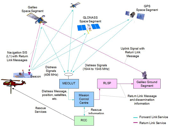
 For many years now, satellite-aided search and rescue notification has been available using personal locator beacons (PLBs). Cospas-Sarsat, as this service is officially known, utilizes geosynchronous and low earth orbit satellites. This results in a couple of limitations — the need to have a direct line of sight to a transmitter (for the former), and the possibility that multiple orbits may be required to independently establish a position (for the latter).
To overcome these issues, a new system is on the way. Medium-Earth Orbit Search-and-Rescue (MEOSAR) will add search and rescue transponders to newer GNSSsatellites, including GPS, GLONASS and Galileo.
GPS
The GPS version has been dubbed the Distress Alerting Satellite System (DASS). There are eleven GPS satellites currently carrying proof of concept DASS technology on GPS Block IIF and IIR satellites. The system is slated to go operational on at least some Block III satellites, which are expected to go into orbit starting in 2014.
Galileo
The first two European Galileo system satellites to test this technology are slated for launch in late summer of this year. Their system should allow a verification message to be sent back to the PLBs, basically letting the injured or lost party know that the distress signal has been received. As shown in the above graphic (source), Galileo appears to be the only system currently slated to offer this sort of capability.
GLONASS
The Russians have launched their first GLONASS-K (third-generation) satellite, which also carries a MEOSAR transponder for testing. Thanks to @PocketGPSWorld for sending me down this rabbit hole!


Very interested in the DASS technology. It sounds like something we could take advantage of.
I’ve got kind of a unique problem and wonder if you have any super cool solutions.
I’m part of a search and rescue outfit in AZ. We send a bunch of folks out into the field and we can’t check their tracks until they get back. Would love to have to a way to see where they are real time so we can ensure they are covering the right grid and be able to go get them in anything happens.
I have found few solutions that might work. Through a dog collar on them (may have minor objections), but besides that, I haven’t seen a good way to keep track of 4 or 5 teams in the field. Have you seen any REASONABLY priced systems that might allow me to do this?
Thanks,
Wolfman
To see them on one screen on a handheld, yes, the dog tracking systems may be best.
If you could get Internet access some way, you could track DeLorme inReach or SPOT units.
On about 90% of our searches we should be able to setup a hotspot through cellular, but not all.
These seem like reasonable solutions. I’ll have to look into them more. Big concern is the ongoing contracts for service.
Right now the dog collars might be winning out.
Thanks.
Matt, did you see this?…
http://garmin.blogs.com/softwareupdates/2012/08/garmin-basestation.html