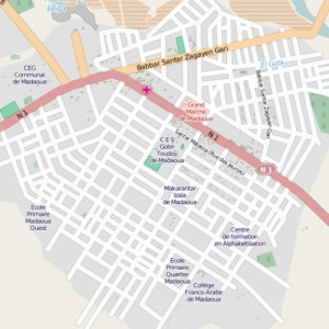
This map of Malamawa can be viewed on OpenStreetMaps thanks to the Mapping For Niger project
Sometimes I take for granted all of the maps available in the U.S. and many other countries. I just assume that if I am trying to find my way to Applebee’s in a new town, I can just punch it in and find the address and directions in seconds, but it isn’t like that everywhere. Places like Niger don’t have any reliable online maps and even the paper maps are sometimes outdated and many towns and roads simply don’t show up. For the last year, a handful of college students are working to change that using GPS tracking and mapping techniques.
As The Observers France reports, the “Mapping for Niger” program was launched by Orsolya Jenei last year. The program trains geography students to use GPS devices and understand digital mapping techniques and basic computer use. The result? Detailed maps that mark roads and important spots (like schools and hospitals) in remote locations in parts of the country. The program is partially funded through a grant from the Rising Voices Foundation.
With a combination of internet-savvy, time, dedication, and a lot of miles, they Mapping for Niger program is slowly helping bring Niger into the 21st century. I don’t know that I would be willing to walk down every single street in my small hometown in order to map it, so it really shows the kind of drive these students have, and the powers of GPS technology.
