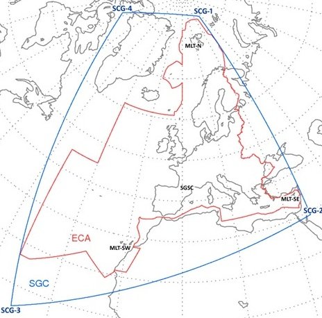
An example of the range of the Cospas-Sarsat coverage area and system. Photo from Inside GNSS
Inside GNSS reported earlier this week that the European Space Agency has completed the tests of their component of the GNSS satellite-aided search and rescue service known as Cospas-Sarsat. Now that the European portion of the system has been completed successfully, the whole system will be undergoing tests to determine accuracy and work out kinks before becoming available in 2016.
Created in 1979 as a collaboration between Canada, France, the USSR and the United States, Cospas-Sarsat is a global satellite system designed to detect distress signals and then send them to the nearest rescue stations for faster locating of those in need. It has helped rescue more than 35,000 people since its first launch.
This service utilizes four ground stations located in the Norwegian Arctic, the Canary Islands, Cyprus and France. Each of these stations has four antennas that are designed to detect distress calls relayed from GPS, Galileo and GLONASS satellites orbiting the Earth. The stations all work jointly to track the satellites together in order to provide better positioning.
This most recent upgrade of the Cospas-Sarsat not only allows the stations to receive calls from the medium orbit satellites (instead of low or high orbits) for better signal, but with Galileo satellites fully integrated, stations will be able to send a message to the distress beacon to let it know that the signal was picked up and help is on the way.
