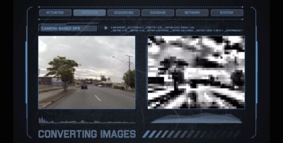
During the last couple of years, satellite GPS has become pretty commonplace and is used for everything from navigation to entertainment to shopping. As accuracy has increased and price has decreased, it’s not surprising that research has been pushed to continually improve this much-demanded technology. Recently, robotics researchers at Queensland University of Technology announced they are developing what is being called the first camera-based GPS device.
This device, as the name suggests, uses images in order to calculate location and help provide navigational assistance. It does not use any kind of satellite or signals, making it appealing to those trying to get accurate directions in urban canyons, underground tunnels or other places where GPS often fails. I first read about this new tech on Techly, and I can’t decide whether it’s genius or not.
But, so you can make your own opinion, here’s how the technology works: images of roadways and paths will be converted into contrast patterns which are then stored on the device. When you’re driving, the device would match up the pictures with the images gathered by a real-time camera and then determine from its databanks where you are and how to get where you want. Pretty nifty. Here’s a video for a better and more visual explanation:
As the video pointed out, the technology has been successfully tested in several different conditions including day, night and extreme weather. Unlike GPS, it isn’t constrained by locations that have a clear view of the sky but, like all technology, it has failings all its own.
The most obvious question I have is storage space. If I wanted to navigate from my home to visit a friend across the state (about a three hour drive) the amount of images that would be required in order to get me from point A to point B for a distance like that is staggering, and that’s assuming that there was only one road to take. I know images take up a pretty small space, but eventually it would add up, and I wonder how fast the computer would be able to calculate routes and location on that scale. As an actual navigation tool, I have some serious doubts. It isn’t an impossible hurdle by any means, but it is definitely an issue. And who is mapping out all of this anyway?
That being said, I could totally see such technology being used by robotics in the future to navigate through indoor locations and other similar scenarios (space station, anyone?). Not only are indoor locations less likely to change rapidly and require rerouting, but the amount of cross-reference images would likely be a bit smaller than mapping out every road in a state. Still, it’s a pretty cool idea, and I definitely applaud the researchers.
If you want to read more about this technology, check out this Techly article. In the meantime, let me know what you think: Is camera-based GPS is the navigational tool of the future? Let me know in the comments!

