Hands on with the Magellan Crossover GPS
UPDATE: This model has been discontinued. For current recommendations, please refer to our auto GPS buyers guide or check out our other Magellan auto GPS reviews.
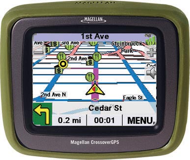
For the past few weeks I’ve been trying out the Magellan CrossoverGPS, which is billed as marrying auto navigation features with those of a ruggedized outdoor handheld. When first announced, this receiver was referred to as the Magellan RoadMate 2500T.
The Magellan CrossoverGPS is very similar to the model below it, the RoadMate 2200T, except that the Crossover GPS adds pre-loaded topo maps. Like the 2200T, The CrossoverGPS offers voice prompted turn-by-turn directions, a 3.5” color touch screen and pre-loaded highway maps of the U.S. and Canada. Additionally, both units feature the SiRFstar III chipset, an SD slot that allows you to load more detailed topo maps or marine charts, an MP3 player, photo viewer, and real-time traffic capabilities. I did not receive a traffic receiver and was not able to test that aspect of the unit.
According to the manual, the Magellan CrossoverGPS has 90 meter topographic maps included for the 48 contiguous United States, though the unit I tested had topo maps of all 50 states and all of the Americas. The manual also says that more detailed (30 meter) topographic maps can be added by purchasing one of the Magellan MapSend Topographic products from www.magellanGPS.com. The screen shows 20 foot contour intervals, but this is likely interpolated from 90 meter data, which can lead to inaccurate contours. The pre-loaded topo maps do not show trails or streams, giving you another incentive to buy detailed MapSend topo maps. Oh yeah, you can’t use your old copy of MapSend to load topos; you have to buy a new version on an SD card, but the U.S. version is not yet available.
Compare prices on the Magellan CrossoverGPS
It is wonderful to have a GPS that does double duty, and the unit has other good things going for it as well:
- As always, the SiRFstar III chipset gets great reception in challenging locations like urban canyons and under canopy.
- The CrossoverGPS has SmartDetour™, a feature that senses when traffic has slowed significantly under the speed limit, and offers to send you on an alternate route.
- An “Exit POI” button provides access to a list of the most common points of interest (POI) categories available at upcoming exits.
- Magellan’s QuickSpell feature grays out characters that can no longer be used as you input a name. This makes for faster and more accurate entry.
- The speaker quality is very good.
- The maps appear to be quite up to date. I was pleased to find a new highway near my in-laws’ house which had been missing on various GPS receivers last year.
- Multiple destinations can be entered as a route using the trip planner feature.
- The unit has text to speech functionality, so you hear “turn right onto Main Street” instead of just “turn right.”
- Enhanced POIs can be created using the Magellan CrossoverGPS PC Tools
application that is supposed to come with the product. This application
was not yet available for testing however. - Once you select a location to navigate to, you are given four options
— shortest time, shortest distance, least use of freeways and most use
of freeways. I found this quite helpful in selecting preferred routes.
For example, I know my nuvi will send me a different way to the nearest
large city than my preferred route. With the CrossoverGPS, I don’t have
to go to extreme lengths to solve this; I can simply choose “shortest
distance” and I get the route I want. Of course, this screen does
represent another step in the process each time you select a
destination.
Unfortunately, the implementation of a number of features is quite weak:
- While the unit has an MP3 player, you can’t play MP3s and navigate at the same time. You can’t play MP3s and look at any map screens, etc.
- I had to have the unit resting on the dashboard to avoid excessive vibration.
- The CrossoverGPS seems to have a small number of POI’s. I found numerous locations missing that I am able to find on GPS receivers that offer 6 million POIs.
- There is no option to show your estimated time of arrival, nor does it show time remaining to your final destination. Instead, the CrossoverGPS shows time remaining to your next maneuver.
- Planning a route ahead of time is a pain, partially because of the low number of POIs. And you can’t pan the map and search for a POI near the cursor location. You can search by City Center, but that’s as close as it gets. And every time I wanted to add a new POI to the trip list, I had to spell out the city name again.
- Nor can you set a point to navigate to (by car) on the map. You can however do this on the topo screen.
- While bright enough in the car, the screen was a little difficult to read outdoors.
- Once you arrive at a waypoint, your distance to that waypoint will no longer update, a flaw that will impact geocachers.
- I could not transfer waypoints to the unit, though I assume this can be done with the forthcoming Magellan CrossoverGPS PC Tools application.
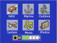
Here are a few screen shots:
The main menu screen allows you to choose what type of map to view, use the MP3 player or use the photo viewer. You can only use one of these modes at a time.

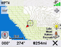
Here is a shot of the topo base map:

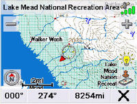
And here is a screen shot showing the CrossoverGPS with a detailed MapSend topo map loaded:
:

Conclusion: The Magellan CrossoverGPS is a great idea, but the implementation is weak.
More Magellan CrossoverGPS reviews
- GPS Magazine posts a Magellan CrossoverGPS review, dubbing it “versatile.”
- PC Magazine gives a 3.5 out of 5 star rating in their Magellan CrossoverGPS review.
- CNet gives a 6.3 out of 10 rating in their Magellan Crossover GPS review.
- Digital Hardware has posted their own Magellan CrossoverGPS review, giving it an 8 out of 10 rating.
- Personal Computer World gives a 3 out of 5 star rating in their Magellan CrossoverGPS review.
- Wired’s Gadget Lab gives an 8 out of 10 rating in their Magellan CrossoverGPS review.
- AudioHolics has posted a Magellan CrossoverGPS review.
- From Down Under, PC Authority gives a 4 out of 6 star rating in their Magellan CrossoverGPS review.
- Another Magellan CrossoverGPS review from Oz.
- And here is an Epinions review of the Magellan CrossoverGPS, AKA the Magellan RoadMate 2500T.
- Fishing Tip has also posted a Magellan CrossoverGPS review.
I’ll be posting more hands on GPS reviews as they appear, but in the meantime, here are some additional…
Magellan CrossoverGPS resources
- Comparing the Magellan CrossoverGPS to the Lowrance XOG.
- PDF versions of the Magellan CrossoverGPS owners manual.
- Tips on using the Magellan CrossoverGPS for geocaching.
- A Magellan GPS message forum on UseNet.
- The official Magellan CrossoverGPS web page.
Compare prices on the Magellan CrossoverGPS at these merchants:
- Check the current Magellan CrossoverGPS
price at Amazon.
- Buy the
Magellan CrossoverGPS
at REI.com.
- Get the
Magellan RoadMate 2500T Traveler CrossOver GPS System
at Tiger GPS.
- Fina the Magellan CrossoverGPS for an amazing price at eBay.


Can I use my Car GPS for Hiking and Geocaching?
A lot of readers have been writing in asking “Can I use my Mio C310X, Nuvi 350 or 660, StreetPilot 330, etc, for Geocaching? Or Hiking?” Well, the answer is not very well. There are some features that make…
I have a Crossover and you can pan the map and even route to a location you touch as long as you’re in 2D view. The Nuvi does a better job at this though.
Wonderful post! Thank you for the useful information! I have a GPS Laptop Receiver
and i have to say that it is very good device!