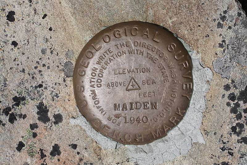
When you are out and about, there is a good chance you’ve stepped on, over or past a plain metal marker set in the ground, similar to the one above. Chances are, you didn’t think anything of it and neither do the hundreds or maybe even thousands of people who walked past it. But, that little mark is actually pretty special, and hunting them down can be just as much of an adventure as geocaching, albeit normally not done in as remote of locations.
These marks are commonly referred to as benchmarks (also spelled bench marks), and searching for them can be quite the challenge as many are placed in places that seem pretty insignificant. There is one located at the edge of the sidewalk near the newspaper office in one city I lived in, for example. But, that’s kind of part of the draw of these little disks. They are almost like hidden gems resting in plain sight.
Unlike Geocaching, benchmark hunting requires a bit more patience and less reliance on technology (sometimes). It’s almost like modern-day treasure hunting, except your treasure is a geographically significant point instead of a tangible item. In short, if you’re more interested in the act of searching than actually leaving behind anything, then benchmarking might be right up your alley.
What are benchmarks?
Placed by land surveyors, benchmarks can be disks, metal rods or even marks placed on the side of a building. Benchmarks represent a point whose position has been measured with a high degree of accuracy. They are used in mapmaking and as reference points and many are part of the geodetic control network (also known as the National Special Reference System or NSRS). Benchmarks are created and maintained by NOAA’s National Geodetic survey (NGS).
There are several different kinds of benchmarks including: Vertical Control Marks, Horizontal Control marks, Intersection Stations, Triangulation Stations, Reference marks or Cadastral marks (which denote boundaries). These marks are placed at established latitude, longitude, elevation or vertical control points. Learn more about different kinds of benchmarks here.
Why is finding benchmarks challenging?
There are roughly 700,000 benchmarks in the United States, but over time many have been lost or simply forgotten. The NGS has a database with information on benchmarks, and hunters can log benchmarks on the site to report conditions and more. Learn more about it here.
Unlike geocaching, benchmarking isn’t always as precise. In fact, depending on the kind of benchmark you’re hunting for, sometimes your GPS will be far less useful than a sharp eye and a written description, making this activity a great mash of technology and old-fashioned treasure hunting. The benchmarks with incorrect GPS locations are known as “location scaled” marks as opposed to “Location Adjusted.” Learn more about both types here.
What I think is so exciting about benchmarking is that these points represent significant points both from a surveyor/cartography perspective as well as historical. Many of the points are located in seemingly random locations and there is a good chance you’ve walked past at least one without realizing it.
What do I do once I’ve found one?
Log it, of course!! Benchmarks can be logged on Geocaching.com, Waymarking.com and the NGS page.
There is actually a competition going on right now hosted by the National Council of Examiners for Engineering and Surveying. Any geocachers who find, log and take a photo of themselves with the NCEES tracker will be automatically entered to win a trip to the last Geocaching Block Party at Groundspeak HQ in Seattle. Learn more about it here.
Happy Hunting!
