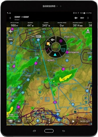
Garmin StreetPIlot onDemand goes social
Garmin is rolling out several new features for its StreetPilot onDemand app for iOS, including Facebook and foursquare check-in, a Wikipedia layer, and the ability to add new voices and custom vehicle icons. Also new is an update to the Garmin Tracker iOS app for the GTU-10, allowing continuous tracking and the option to share [...]
Garmin StreetPilot Onboard iPhone app gets traffic camera option
Tired of inaccurate traffic data? How about live traffic camera images instead? Well that’s a new option as of today’s update to the Garmin StreetPilot Onboard app for the iPhone. The update will also add live weather info and the ability to share points of interest via Facebook and SMS. While the update is free, [...]
Garmin Fit Apps and ANT+ adapter announced
UPDATE: Looks like the ANT+ adapter for iPhone will be available later this week. Garmin has announced the Garmin Fit app for iPhone and Android this morning, and an ANT+ adapter for the iPhone (that link wasn’t live when I posted this, but it probably will be later this morning). This is Garmin’s first fitness [...]
Enter traffic circle and keep left?
Okay, maybe it’s unfair to call out Google Maps Navigation for this error. After all, every GPS can give you faulty directions, no matter what database they are using for road data. But I’ve never seen this type of error on a unit using NAVTEQ or TeleAtlas maps. Fail!
Garmin StreetPilot onDemand for iPhone only 99 cents
Garmin has announced yet another version of their iPhone app – StreetPilot onDemand. Designed to attract help navigate impulse buyers, the price of admission is only $.99 which gets you 30 days worth of Garmin goodness. The company says that this is also… …the first iPhone navigation app to include multimodal pedestrian routing, with bus [...]
Garmin StreetPilot Onboard iPhone app
Recalculating! Garmin has done a course correction with their iPhone app, rolling out a version with onboard maps, eight months after the release of their original StreetPilot app that used offboard maps. Considering AT&T’s reception problems in many areas, it’s probably a smart move.
Google Maps Navigation to use onboard maps?
According to All About Phones, a Dutch website, Google Maps Navigation will soon have a full-blown offline mode. Late last year, with the introduction of Google Maps 5.0 for Android, GMN moved to vector graphics and improved route caching. But this new capability would allow you to plug in a destination while outside of cell [...]
Preserving cellphone battery life in the backcountry
I imagine that a lot of our readers are trying out their smartphones in the backcountry, using mapping applications for navigation. One of the problems with this (and there are several), is that few things will drain your battery faster than your phone searching for a signal where there is none, or where reception is [...]
SPOT Connect review
Hands on with the SPOT Connect The SPOT Connect allows you to communicate with loved ones and social media, or call out search and rescue, even from remote wilderness areas without a cell phone signal. Like the DeLorme PN-60w + SPOT Communicator, the Connect allows you to compose messages on the fly, but instead of [...]
New iPhone app pays you to help fix TomTom maps
That’s right. Why make all those Map Share corrections for free when you can get paid? That’s exactly what the new iPhone app Gigwalk does. It’s not a TomTom product; they’re just the company’s first beta customer. If you’re in one of their initial seven metro areas, you can get $3 for a few minutes [...]


