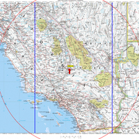
The U.S. Coast Guard has posted dates and times for GPS "service interruptions." The purpose is "to conduct GPS interference tests, exercises and training activities that involve jamming of GPS receivers." Affected locations are China Lake, CA, White Sands Missile Range, NM, Cape Canaveral, FL and the Nevada Test and Training Range.
Though the testing is brief (a few hours at a time), it is of multiple day duration. And don’t think it won’t affect you. Check out the map of the China Lake test area to the left. This is a massive area, defined by the red range ring (230 nautical mile radius) and blue lines (testing does not extend beyond longitude 115W and 120W). As shown, it includes all of L.A., Joshua Tree, Sequoia/Kings Canyon, Death Valley and Yosemite. I’m hoping the area really isn’t that large. Please, feel free to comment and tell me why it isn’t this extensive. There are some caveats in the test announcement; here is the full text:
"230 NM RADIUS OF THE NAWS CHINA LAKE/ARMIT AGE AIRPORT (NID) AT FL400, NOT EXTENDING BEYOND 120W AND 115W. THIS AREA DECREASES WITH ALTITUDE TO A CIRCLE OF 175 NM RADIUS FROM NID AT FL250 (BOUNDED BY 115W AND 120W), 120NM RADIUS AT FL100 (INSIDE BORDER OF
CALIFORNIA), AND 120NM RADIUS AT 4,000FT AGL."
A little research turned up the following definitions:
- FLIGHT LEVEL (FL) – A level of constant atmospheric pressure related to a reference datum of 29.92 inches of mercury. Each is stated in three digits that represent hundreds of feet — flight level 250 represents a barometric altimeter indication of 25,000′; flight level 255 an indication of 25,500′.
- AGL – Above Ground Level, as a measurement of altitude above a specific land mass, and differentiated from MSL.
EDIT: In addition to the comments below, discussion about this topic is also taking place on Groundspeak, Geocaching.com’s message board.
Thanks to Sam Wormley for posting links to the Coast Guard documents at alt.satellite.gps and sci.geo.satellite-nav.
Map Notes: Base map exported from National Geographic TOPO!. Range rings generated using OziExplorer.

“And don’t think it won’t affect you.”
I _know_ it won’t affect me. This kind of testing has been going on for years. I’ve been on the ground near some of them with a survey crew and never detected a problem.
Your alarmist map grossly overstates the effect. How often do you fly over one of the test areas? That’s right, never.
So are you saying there is no effect on the ground? It was unclear from the USCG information as to whether this was slight signal degradation or complete interruption of service.
March 13 thru today march 15 I have not been able to lock on a satellite in Sandiego thanks to the testing. I have 3 Garmins, so I know its the testing.
Hi Gary-
Thanks for commenting Gary. You would think that the government would find another way to test. How many times did you try and fail to get a lock? I’m just wondering if they jam all day long, or only for short intervals. This could really mess you up if you were relying on your GPS for backcountry navigation. As they say, always carry a map and compass, huh?
After you keep a women curious about you, they should gradually get increasingly more enthusiastic when they look at you.
Become familiar with learning to make the girl more and more serious
about you each time you communicate and you will then build up a great deal of
energy that she will ultimately start out running after you.
When you put on these techniques, text messaging you gets to be a thrilling venture for
her.
That is a great tip especially tto those new tto the blogosphere.
Simple but very precise information… Thanks for sharing this one.
A must read post!