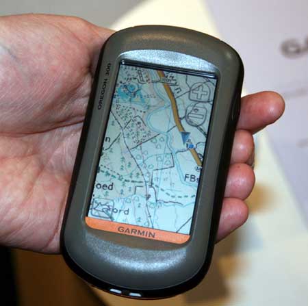
UPDATE: Garmin UK has a page up on the product, dubbed called Garmin GB ActiveTM.
Garmin Oregon owners in the UK will soon be able to view Ordnance Survey raster maps on their units. Raster aerial imagery has been available on marine units since the release of the Garmin Colorado and Oregon 400c/i models, yet we landlubbers have had to make do with vector maps.
The OS maps, due to be released early next month, will reportedly overlay vector data on top of raster imagery, allowing for turn-by-turn navigation.
Hopefully, we’ll see a similar Garmin product in the U.S. before too long, combining USGS topo maps and City Navigator highway routing, though it probably won’t show up before Garmin finishes rolling out their 1:24,000 scale vector topo maps.
For now, if you want USGS topos on your GPS, the best bet is DeLorme, which is getting ready to introduce their next generation handheld, the PN-40, later this month.
Via Groundspeak and OutdoorsMagic.


I’d be happier about this if:
– The maps weren’t so expensive: 129 pounds ($250) for just the National Parks in Great Britain. These cover about 14,000 square km, which sounds big, but is less than the size of Connecticut. Only two US states (DE and RI) are smaller than that. At this cost, covering USGS topos for a large state like CA or TX would be absurdly expensive.
– Like Garmins 1:24K vector maps, they’ll only be available on microSD cards. So you won’t be able to put maps on more than one unit at a time, or combine them with other mapsets.
For the list price of an Oregon unit, you’ll be able to get a PN-40 and a copy of xMap, which will let you upload any raster image (maps, aerials, satellite) to the GPS unit. I wish the display were larger, but other than that, it’s the better choice.
Has Garmin yet done anything about the appallingly dull Oregon screen?
The versions I’ve seen so far are almost unusable outdoors in bright light!
Thus, while it will be great to have UK OS maps on board (they’re simply superb maps), Its a little pointless if you have to go into some dingy moorland pub just to read the them.
@Leszek – Yep, it is pricey. Still, the full Garmin package is an out of the box solution that’s easier to use than the PN-40 + xMap. That would give it broader appeal even at a higher price point.
@Steve E – You are too funny!