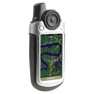
What makes aerial photos and USGS topo maps so different that we’ve been waiting years to get them on our GPS screens? A few companies have started offering these images in the past year. But so far, Garmin, the king of GPS receivers, has not had this capability (with the exception of limited aerial imagery of ports on some marine units).
To address this, we first need to define two types of imagery and the problems they can cause. I’ll close with what’s coming from Garmin and Magellan in this regard.
Raster and vector graphics
All those nice graphics that show roads in 3-D, POIs and street names on your auto GPS come from data files that are made up of lines and points. There are no images stored in system. The "images" you see on your screen are generated on the fly and are called vector graphics.
Aerial photos on the other hand are pictures rather than data files; these are known as raster graphics. USGS topo maps are also raster imagery. These true image files eat up a lot more storage space than vector files.
Barriers to successful implementation
So memory is one problem to be overcome. And you can’t just have one image for a given area. If you want to be able to zoom in with your unit, you’ll need a new image for each zoom level (or live with a slightly out of focus view). All of a sudden the memory storage needs have skyrocketed.
Processing power is another problem. Raster imagery means slower map redraws unless the hardware is beefy enough to handle it. This problem plagues the DeLorme PN-20 and the jury is still out on the Magellan Tritons just now arriving in consumers’ hands.
Useful in the backcountry, but in your car…?
There’s no doubt about it, aerial images can be very useful in the backcountry. Mountain bike in dense forests? It’s great to be able to see where logging roads go. And if the resolution is high enough, aerial photos can even help you find hiking trails you might otherwise miss. It’s also nice to have a topo map on the screen that actually looks like the one in your hand. (You do carry a hard copy map in the backcountry, don’t you?)
Yet in the car, I’m not so sure about usefulness. That is until we get birds-eye or street view imagery, and that’s going to really challenge the hardware!
New GPS receivers with this capability
The Magellan Triton, as mentioned before, is just hitting the market. It can accommodate raster imagery in the form of National Geographic TOPO! maps. And since Magellan has opened up to other providers, I hope we’ll soon see someone offering aerial photos for these units.
Word has recently leaked about the Garmin Colorado series of handhelds which appear to support raster imagery, as shown in the photo at the top of this post. But we probably won’t know the details until January. So stay tuned for the latest on the Magellan Triton and Garmin Colorado series. I’ll keep you updated as to their capabilities and performance.


I’ve used the PN-20 and don’t find the imagery slow when used for its intended purpose: slow speed activities like kayaking, hiking or geocaching. Indeed as you mention its quite useful, however I do agree that at car speeds its slow and of limited value. (Give me POIs and vectors in the car)