UPDATE 2: I’ve now posted my hands on review of the Garmin GPSMAP 78s. I also have a review/resource page up for the GPSMAP 78.
UPDATE: GPS City now has the 78s and 78sc in stock.
I’ve had my grubby little hands on the Garmin GPSMAP 78s for a few hours now and I wanted to give you a sneak peek at what you can expect from Garmin’s newest handheld platform, which seems to be a hybrid — taking the best features of the Oregon line and marrying them with the oh so popular 60/76C(S)x series. Before I go any farther, let me say that handheld units are complex beasts and can be very challenging to review. So I have a request; add your comments below and let me know what you want covered in my full review. Some things I’ll be able to answer right away in the comments here; other things might just be beyond my experience to be able to answer at all. But hey, please do chime in.
For today though, I’m going to give you tons of screenshots, a few photos and some first impressions. Bear in mind that this is likely the same platform and menu layout for the forthcoming (but as yet unannounced) 62 series.
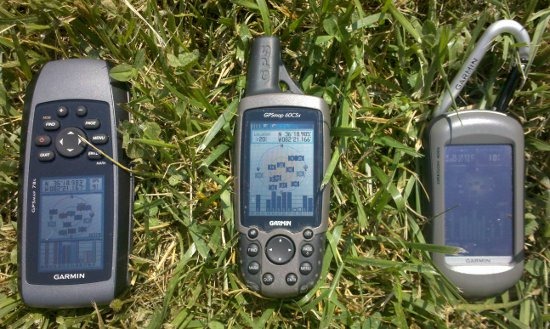
I was sitting inside when I noticed a reported accuracy of 13’. At that, I jumped up, grabbed my 60CSx and Oregon 400t and headed outside for a test. The results of this less than scientific test — the 78s (9’), 60CSx (20’) and Oregon 400t (10’). The 78s seemed to settle much more quickly than the Oregon, but I’ll need to do more testing to verify that.
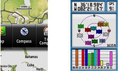
Screenshot capability is built-in, but they don’t seem to render in true color. When you press the Page button, a slider menu comes up on the screen (see the left image at the top of this post). The menu item that appears is the next screen in the sequence. After a second or two that screen will automatically open. Or you can press Enter to go there right away, or continue pressing Page to advance to other pages in the sequence; stop on one and it will open. The slider menu items and their order can be customized. I think I like it.
Here is the main menu: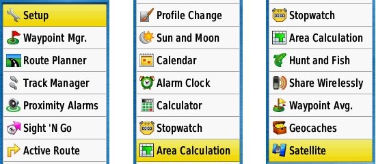
The compass screen and compass menu: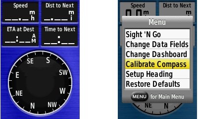
The left shot above is in night mode. You can change background and highlight color for day and night modes. Dashboards (and profiles) are present, just like on the Oregon and Dakota series. The screenshot at right below shows text entry.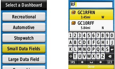
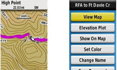
Geocaching options appear nearly identical to the Oregon and Dakota series (notice the dashboard in the screenshot at left, below). Unfortunately there is no way to filter geocaches, as we’ve seen in the Lowrance Endura series and more recently in the Magellan eXplorist GC.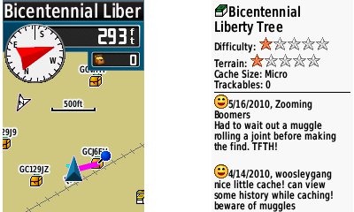 I was very glad to see the newest track navigation features included, as can be seen in the screenshot below at left. To the right is a track detail page.
Odds and ends
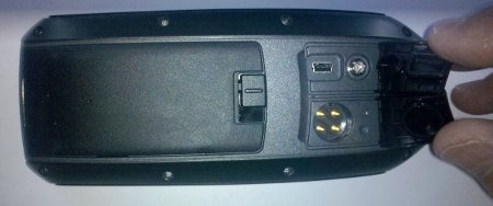
I’ll close for now after a few other notes. I haven’t tested this in a full range of conditions yet, but daylight visibility seems to be pretty close to my 60CSx. The software version is 2.10; there is no indication of chipset firmware. A wrist strap is included, which is threaded through just below the screen. When received, the unit showed 1.72 GB of 1.80 GB of memory available. You can tap the power button to show the date, time, battery level, GPS status and backlight adjustment. For more details (and in case you missed my tweet yesterday), the Garmin GPSMAP 78 series owners manual has been posted online. My initial impression is very positive. I can’t wait to give it the full testing treatment.
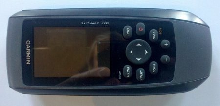
Check out the photos below and then fire away in the comments.


I am interested to see if the stopwatch can do laps by distance, like the 60Cx series.
THe Oregon doesnt support that.
…Brent…
Yes, the screen is identical to the 60CSX. Except when I press menu, I only see “Lap by Distance.” On my 60CSx, I also see a grayed out (unavailable) “Set Lap Distance.” Hope that helps.
Mine 60csx normally get <10' accuracy. What chipset is your 60csx using?
SiRFstar III. Which is yours? I’ve been wondering if my 60CSx’s performance is degrading. It started seeming a possibility a firmware upgrade or two back.
Mine is MTK. Can you tell what chipset is the 78s using?
No, there’s no indication of chipset or chipset firmware. GPS Fix believes it’s the STM Cartesio…
http://www.gpsfix.net/garmin-gpsmap-62/
1. How about the WAAS issue the Oregon has? Did they fix it? Does the 78 acquire WAAS and keep the lock?
2. I see GPS altitude on the satellite page (well I assume it is). Any other way to see GPS altitude only?
Thanks
Amir K9CHP
Not the best conditions right now (thunderstorm that I don’t want to stand out in), but a quick check shows D’s on my 60CSx, but not on the 78s or Oregon. Will check more ASAP.
I can’t find a setting on any of the units for GPS elevation vs barometric altimeter, but surely it’s there. Any idea where to find it on the Oregon or 60CSx?
It would be a data field on the map/compass/altimeter page. The OR/DK don’t support this so I’d be surprised to see it on the 78. Look for something like GPS Altitude I’m guessing when you change the custom data field.
Thanks Scott. Nope, I don’t see it.
Hi,
The GPS Elevation in GPSMap60CSx you can find in Satellite screen by pressing Menu button.
Elevation taken from barometric sensor is in Altimeter screen or Compass and Trip Computer’s data fields.
Definitely missing from the satellite screen menu. Too bad. That could be useful. Should be easy enough to add back via a firmware update though.
To clarify… The altitiude reported on the GPS screen does appear to differ from that shown in elevation data fields, so I think we can assume that the satellite screen reports GPS elevation.
Things i like to know:
-Can you change the menu layout to a “classic” Style?
-How is the Find Menu? Is it like the old ones or like Oregon (waypoint manager etc…)
-And most important: Is it possible to move the map-cursor diagonal like on the 60csx? This did not work on the Etrex series, thats why i am asking…
I forgot:
does the mechanism for locking the battery cover feel solid or weak?
Battery cover (and latch) feels very solid (IMHO).
also important: Can you set the speed and time for the magnetic compass to be enabled?
Oops. Looks like that one is missing.
Missing relative to the 60csx, the same as the OR/DK.
Ah, thanks for keeping me straight. Looking forward to reading your take on this thing, BTW.
If you mean back to the 60CSx style, I don’t see any way to do that.
The Find menu is a list, like the ones shown above. It includes Recent Finds, Waypoints, Photos, Tracks, Coordinates, All POIs, Cities, Tides, and Geographic Points. Looks like you can change the order of most lists by hitting the Menu key.
Yes, the map cursor works diagonally.
Re the “classic” style, I would like to see this too. On my Oregon, there are profiles that allow me to change the look and feel of the unit. On the main menu look for an option called “Profile Change”. Hopefully there will be a “Classic” style profile or something that. If they have this option on the 62, I think I might actually upgrade from my old faithful (60CSx)!!
I would guess it is a display settings option. Even from those few screenshots above you can see that Garmin has included the level of options from it’s older flagship GPSs! I have been holding out for Garmin to give us something like this! Hmm just like my old 60Csx, but better! Can’t wait to get one of these…or a 62!
Well I’ll be damned. There’s a classic profile option that gives you a classic looking main menu and gets rid of the slider menu!
I’m Sold!!! So is there a way to remove the slider menu from other profiles too?? Is there still a 1 to 2 second delay between pages if you don’t have the slider menu?
It should work like the Oregon, where you create a profile while in Classic mode and it picks up those settings for the new profile. And yes, it gets rid of the delay.
I’d hold out for the 62. I still grab this thing upside down half the time!
Do geocaches and waypoints load separately like in the Oregon?
How many caches can be loaded?
Do geocaching.com icons show up for the geocaches? From your screen shots, it doesn’t look like they all do. I see a garmin chest icon, and a GC.com multi-cache icon.
Can entire cache pages be loaded as POIs, like on a Nuvi or Oregon?
Bob, I think in one of the shots you can see the multi-cache icon.
yes, but the traditional icons are showing garmin’s icon, and not one from geocaching.com
Thanks Scott!
are geocaches and waypoints handled separately, like the Oregon?
In other words, do Caches take away from your 2000 waypoints?
Can you clarify your question about geocaches and waypoints loading separately?
Unsure about how many caches can be loaded.
I’m seeing symbols for multis and puzzle caches.
No idea on the last one. Sorry!
Rich,
I think the question is whether the geocaches show up under the geocaching menu, and waypoints under the waypoint manager. I’m guessing they must based on the cache description you’ve shown.
As Bob points out there is a bug/difference with how the 78 displays an icon for a traditional cache, it uses the treasure box waypoint symbol instead of the groundspeak icon.
I need to look into this some more. I’m seeing some nearby GC codes showing up in the waypoint list, but I think they got there through a .gpx waypoint file I transfered. They do not show up on the geocache list, though I do see a pocket query I loaded yesterday. Hope that makes sense.
That’s the problem I’m having. Only caches downloaded directly from geocaching.com show up as geocaches; anything transferred from a GPX file is a waypoint. It’s different from the 76CSx I’m used to, but I suppose it’s a matter of learning a new system. If I don’t like it, I can go back to the 76. I got the 78 for free, so no loss.
Any Rumors of a Etrex that has these functions?
Haven’t heard that but it sure would make sense for 2011.
Hi,
how thick is the device? Is it sigificantly less thick than the 76 series?
Is the sound louder than the 76 (or 60s) series?
Thanks
Andreas
And: Does the “beeps” sound as crippled as on the Dakota (i dont know if it is the same with oregon) but my 60csx sounded more “clear” and the Dakota beeps are somehow crippled.
I don’t have a Dakota. My Oregon doesn’t sound crippled but I do believe the 78 is a bit louder.
Specs say both are 1.2″
Seems a bit louder than my 60CSx.
Thanks. Maybe the unit i have is faulty…
Looking forward to get the 78, but i guess it will be june or july here.
i hope we will see a lot of high-res images comparing oregon and gpsmap 60/78 side by side in daylight (map view etc. Cause the sat-page is a bad example at the oregon. its all black)
For this sort of thing, it is nearly impossible to get a photo that mimics what the human eye sees. It will probably be easier to get photos comparing the 60 and 78 series, leaving the Oregon out.
Hi,
some words to the shown accuracy. The EPE (estimated positioning error) has absolutley no explanatary power. I tested over 3 weeks a 60CSx with Sirf3 and a 60CSx with MTK. Mostly the MTK shows the better EPE error, but verifiable the Sirf3 was more near the real position. I experienced that the MTK was also a little bit lying, showing position with good EPE but didnot receive any satellite.
Another time I also experienced an EPE of 5m but in reality I was more than 50m off position caused by assymetric multipath error.
Paul
I agree that is a very weak test for accuracy. At a second location yesterday afternoon, in light rain, the 78 didn’t perform as well. I’ll be testing the 78 against other units, under canopy, and post the tracklogs in my full review.
How does the display compare to the perfect 60CSx and Oregon in direct sun light
I’ll be doing more tests, but my initial take is that it’s roughly equivalent to the 60CSx and way superior to my Oregon 400t.
Well seems to be a carbon copy or the OR for WAAS, hum…
Ditto for GPS altitude, it cannot be set in the 60CSx, not OR so double hum…
So it looks for me, owning a OR400i that I would trade the touch screen (which I like) for a brighter but smaller non touch screen. Sort of an even trade but then I have to pay for the new GPS with little new features for me
Amir K9CHP
Yes, I think this one is going to primarily appeal to folks who want a brighter screen, fear potential touch-screen fragility, or have big, stubby fingers. It looks like it will be a pretty good unit, but I don’t see happy Oregon owners (especially those with the 450’s improved screen) deserting the platform for the 62/78 series.
Proximity Alarms!!!
Rich can you give us some details about this option in your screenshot? Can you set a distance/radius? Change sounds? Does it have any “menu” button options when your in this feature like older units?
This looks awesome.
You can enter the radius — units can be changed (miles, feet, etc.). You can set a proximity alarm, approaching proximity alarm, leaving proximity alarm and an upcoming speed alarm.
Wow, this is quite a powerful feature.
Great this sounds even better than the 60CSx – Does the GPS show the proximity alarm circles on the map?
Yes it does.
Is there an option for the page button to behave the same as in the old 60csx?
Yes, there is a classic profile option that removes the slider menu.
The WAAS news is a bit discouraging. Garmin has known about the WAAS issues with this chipset for years now – when will they get around to fixing them.
Your timing is impeccable Leszek. Half an hour later comes an Oregon beta that fixes WAAS! I’m betting this gets ported to the 62/78 before too long.
Woohoo! Now there’s nothing standing in my way of getting a 62, apart from Garmin actually announcing and then releasing it ;-). I assume they’re waiting for after Memorial Day, when the REI/Cabelas/Bass Pro 60CSx blowouts are done.
Yeah, I’m looking for an announcement next week — that’s just a semi-educated guess though. Then the next thing is, do you wait for the price to drop?!
Do you have a URL for that Oregon beta? THanks.
Oregon x00 software version 3.81 Beta http://www8.garmin.com/support/download_details.jsp?id=4741
Oregon x50 software version 3.51 Beta http://www8.garmin.com/support/download_details.jsp?id=4743
Thanks Rich. The good news is that the BirdsEye aerials have now three level settings and that the brighter of the three works fine outside on a sunny day with high clouds. The bad news is that WAAS is NOT, repeat NOT fixed, no “D”s, no lock on either 51 or 48 but when there is a bar, never a filled one, numerical precision seems to go down all the way to 11′ but never stabilizes there. So something must have been done but not enough. It will be interesting to see if the 62/78 will work better once the update is released for them.
I did not check the other fixes.
Amir,
3.51 sure fixed WAAS on mine (550). With update, it lost all the almanac and had to re acquire, completely one by one.
Was getting solid bar on 51 and Ds on all acquired sats even before all sats located.
Mine went to 3.51 and (4.46 FW also).
Well the fix did something to my Oregon 400i as while driving, going west in an relatively open area, I got GPS precision down to 10′ but no solid bar for WAAS sat, nor “D”s. When going the opposite direction my precision went back to “normal” no WAAS correction, which is logical as the car shielded the satellite.
While playing at home, I saw on D once, no solid WAAS bar though.
After update WAAS works for me.
Units: Oregon 450 and 400
All D’s stable and 8ft EPE
Remember after this update it will have to start up and reload all of the satellites and that takes a minute or two, but after that it is smooth sailing…
Do custom raster maps work?
Indeed they do! Thanks for nudging me to try it.
Rich – The Garmin specs say “No picture Viewer” but also say the 78S supports “Photo navigation”. How do you select a geo-coded photo to navigate to? By name only?
Find > Photos. It has three Garmin locations pre-loaded, and shows no other options for sorting the list. There’s no photo viewer as far as I can tell. I assume you just drag geotagged images to the directory via USB.
With Find > Photos do you see thumbnails or file names?
Thumbnails. Select one and then hit Menu > Review Point and you can see a slightly bigger version of the image.
OK, thanks, that would work for me. I really don’t see the point of a picture viewer on a GPS unless it has a built-in camera.
Can you check if the “Track Up” setting has an associated Zoom seeting like the 60CSx or if it’s Track Up at all zooms like the Nuvi. I like the former setting for motorcycle use as I prefer North Up (to tie in with my paper maps) but like Track Up to see upcoming turns when zoomed below the 200′ level (let’s me “see” around corners ….).
Possibly! Can you tell me exactly what setting you’re looking at on the 60CSx? I see map settings for North up, Track up and Auto, which appears to be just 3D mode. The map setup settings look more similar to the Oregon than the 60CSx.
The 60CSx seeting I use is “Map Setup – General / Orientation” (in the Map screen go “Menu / Setup Map / use the leftmost of the 6 icons”). The 2 choices for Orientation are North Up and Track Up. If you choose Track Up, then a new setting field appears called “Below” and I set that around 80metres. Most of the time I see the map in North Up as I’m generally at about 1.2Km zoom (the max zoom out that still shows backroads), but when I get on unfamiliar twisty roads I zoom in to 80m and I get a fast moving preview of the upcoming turns in Track Up mode. Works really well for me.
Thanks. I do not see an additional field when I choose track up. I’m not that familiar with how the Oregon (and 78?) series works in Automotive Mode. Perhaps it does something similar, but without the ability customize the zoom level.
The Dakota and Oregon don’t support this “switch at zoom level” feature like the 60csx.
What about the ability to list waypoints by name instead of just by nearest ?
Find > Waypoints > Menu gives me a Spell Search option.
Menu > Menu > Waypoint Manager > Menu gives Spell Search, Search near and Delete All options.
There is no simple sort by name option; just spell search.
The 78S User Manual says you can view saved AND archived Tracks. Does it now do archiving like the Nuvi 765T or is it still the 60CSx style of writing a daily GPX file to the mSD card?
If it allows you to view the GPX file on the mSD card, can you try loading a GPX file created in Mapsource with many track segments and greater than 10K points and see if it loads? It may be limited to tracks created by that GPS.
It should work like this…
http://garmin.blogs.com/softwareupdates/2010/03/getting-more-with-automatic-track-archiving.html
I’d be surprised if you can view tracks > 10K points, but I will try testing this feature for my review and should be able to answer your questions.
That’s unfortunate – I really like the 60CSx ability to record one fully detailed tracklog named yyyymmdd.gpx each day, rather than my Nuvi’s 1.gpx, 2.gpx, etc. When I geo-code my photos I just look at the jpg date(s) and then copy the same date gpx file(s) to that folder and GPicSync does it’s work. With my Nuvi tracklogs, I have to open the file and see what range of track dates are in that file (just the gpx file date isn’t enough).
With the Nuvi archiving, and now presumably the 78S, the archived file is never over 10K points so it’s not an issue. The 60CSx daily gpx track can exceed 10K points, so it wouldn’t be able to be fully displayed on the GPS if Garmin retained that “Track Points” setting of 3000 or 10,000 (which is the number of points to display and NOT the number of points to record – the User Manual has been misleading on this years).
However, it would still be interesting to know if a Mapsource-created tracklog can be uploaded to the Archive folder and then opened like the true archive files.
Remember that on the Oregon (550)3.26 beta there was the ability to do “Daily” archive. Then that ability disappeared when it changed to “released” version, BUT that fact(that it was dropped) was noted and “they” (Garmin) said it would be returned in a later full version after more testing.
I too like that feature and immediately chose it when it was first available.
Do roads render the same as on the Oregon, or like the 60csx?
I don’t have CN loaded, but they look more like the Oregon to me.
That\’s going to make things a lot esaier from here on out.
@Amir – First WAAS acquisition will take awhile. After that, ephemeris data should be cached. I left mine sitting out for about 10 minutes, came back and had WAAS. I’ve seen one other report of someone not getting WAAS with the update, but they were in Northern England.
After forgetting my OR 400i on my grill (grill was off) for well over an hour, WAAS was acquired! I tried it again in a different location with similar results, not in a few minutes for WAAS acquisition (seconds for the other sats).
So WAAS works now on the OR 400i!
Track log support compared to 60CX:
Can you display 2 or more saved tracks (on the map)?
Can their color be set individually?
Can the Active Log track color be set?
What recording resolution can the active track be set for (60cx can do 1 point/second or 0.01 miles). Does that dump to an “infinite” archive, like with the 60CX to memory card?
Great questions!
Can you display 2 or more saved tracks (on the map)? Yes
Can their color be set individually? Yes
Can the Active Log track color be set? Yes
What recording resolution can the active track be set for (60cx can do 1 point/second or 0.01 miles)? You can go as low as .01 miles.
Does that dump to an “infinite” archive, like with the 60CX to memory card?
I think so. I will be doing some micro-SD / track testing.
the 60CSx and OR 400i can do better than 0.01 miles. Set units to yards and you can set the logging to 1 yard, maybe even less than that, I have not tried less than 1 yard.
Just checked. You can set units to yards and interval to 0.01 yard.
I remember a discussion I had and it seems to me that the logging is set at the maximum of once per second. So depending on your speed, you may not get all the points in the log even when set to 0.01 yard. Now moving at 1/100th of a yard per second makes me wonder why you would ever need a GPS when your speed is 36 yards/hour?
I set it to 1 yard when working water recovery with my dog, where precision is really needed to narrow down the search area for the divers. On land I use 5 yards.
Is your unit a test-sample or your own? Can you open it and look if its cartesio or not?
It’s a review unit / loaner from Garmin. Either way, I wouldn’t be opening it up.
GpsPasSion seems to think the 62/78 series have SiRFstarIV chipset: http://www.gpspassion.com/forumsen/topic.asp?TOPIC_ID=135456
When doing field tests please keep in mind that 78 series has probably patch antenna which works better if it’s held flat and 60 series has quad helix antenna which works better in vertical position.
Thanks. I’m not 100% convinced it makes that much difference. Nor am I likely to be able to test them in different positions. Sorry!
I believe this GPSMap78s has the same antenna as the older 76 series. If that is the case, then the antenna is a quad helix, that starts where the Zoom buttons are, and is positioned vertically, to the top of the case.
I see the FCC has a hold on the GPS, and do you know what is up with that?
Watch the FCC Shots. You can clearly see its a patch
We will find out for sure when we find out for sure !
Think about this…..the 60/76 series had a Quad Helix antenna which worked best when held nearly vertical, …..and a 2 axis compass which required the unit to be held flat/level to work properly.
(DUH ! No wonder all the “my compass acts wierd” “problems”)
NOW, the 78 series come out with a “Patch”antenna ( maybe, No one knows for sure)and previous patch antennas work best “flat”, but the 78 has a 3 axis compass !
I would bet that the 62 will have the same “innards” (antenna also)
as the 78.
Ain’t life Grand….but wierd!
my guess is, that a patch antenna works better for GPS.
I had a 60csx with the new reciever. It took all the signal-reflections from housewalls. Everytime i passed a house the track was like magnetic to the house.
Got some field time today. Really liking the interface. It’s pretty easy to navigate, and I haven’t even customized a profile yet. I’m liking the slider menu. It may actually be faster than “classic” if you run many screens and are trying to get to one several pages away.
I would really like to see some track comparisons between the 60, Oregon, and the 78. Because the chipset is still unknown it would be a great “blind” test.
Another question that I have is: How does the 78 do at slow speeds? Can it reliably tell your speed under 1 Mph, just like the 60 does. This is my biggest grip with the Oregon series.
I’ll definitely be doing and posting tracklog tests. I’ll also add speed comparisons to my to-do list.
Sure looks like a patch…
http://www.gpsfix.net/garmin-gpsmap-62/
@grasscatcher – 62 series pics sure make it look like a quad helix though. I’m trying to recall breakdown pics of the 76. Did it really have a quad helix in there?
Yep, the 76 series has always had a Q H antenna. The “shape” has nothing to do with what type of antenna. I’ve always thought that the 60 “knob” was just something for the dog to chew on,and based on several forum posts, they have.
After Garmin said (in e-mail exchanges) that the WAAS problem was due to antenna design , I became a non-fan of the new Oregon “ceramic” antenna….HOWEVER, “they” have made several software changes ( it’s never been listed as “changes” in the list) that have resulted in noticeable changes. I now don’t consider the ceramic antenna to be a problem, especially after the latest beta version which “fixes” WAAS.
I haven’t compared my 76CSx and the Oregon 550 “under canopy” since the latest version “fix”.
I’ve just checked specs for 76 and 60 series and found that both have quad helix antennas. I am sorry for creating confusion.
Besides with sensitive chipsets now it is not so important.
First of all sorry for the long list below, pls dont feel obliged to answer all of them, just consider it as a menu for having fun later
1. Does 78s save the waypoints to the SD card, too, I mean as part of the gpx file or does it log it only into the internal memory as 60csx does?
2. Can the basemap(s), which is a part of the internal memory in case of 60csx, be removed from 78s? I mean without bothering the user in the Map setup menu where you can see the list of the maps.
3. What is the step size of the elevation data logged in the gpx file or in the internal memory (active log)? It is 0.4807129 meter in case of 60csx, I’d be happy if Garmin decreased it.
4. Is the barometric sensor of 78s sensitive to press the buttons? Again 60csx is. You can wasily check it pushing buttons hard while watching the Plot Over distance or Plot Over Time in the Elevation Page.
5. Did you experience that the elevation profile of the log of 78s is smoother that that of 60csx is they are more or less of the same quality?
6. Have you tried to check some gpx files logged by 78s with Mapsource? Could you experience any corrupt files or not? If yes, was the whole file corrupt or did 78s just forget to log for some seconds or could you experience the time jump phenomenon (it’s also called as “leap seconds” phenomenon in the jargon of some 60csx groups)
7. Can you use the accessories of 60/76 series for 78s, I mean the bike mount, car mount etc if you have any at all, of course?
8. Is it easy to set a distance in log setup menu even in case of wishing to set it to less than 10 meters? With 60csx you must change distance measure system to yard in unit setup than set it to eg 3 yard than switch back to metric system.
9. Are , and fields filled using the same logics as in case of 60csx?
10. Do you have only 24 custom waypoint symbols (=icons) or did Garmin decide to increase it? Actually with 60csx I found a bug when marking waypoints with an icon numbered as 023 (it is the last from the 24). Garmin admitted it, but never fixed it. Anyway it would be too cruel to ask whether 78s has the same malfunction or not
11. Do you have to live with the purple-like color of the proposed way when navigating or can you change it?
Whoa! Okay, I’ll try to answer some here, some in the review…
7. Doubt it. They are different sizes and shapes than the original series.
8. Same thing. Have to set units separately.
9. Can you restate? I don’t understand.
7. Got it
8. Maybe you misunderstood me here. In case of 60csx the minimum distance log is just 10 meter. You cant choose a number less than 10. But with the “yard trick” I described you can. Are you able to set it less than 10 meter in the metric system?
9. Sorry but because of using the triangle-like brackets, I mean less sign and greater sign, some part of my post disappeared. I wished to asked whether 78s fills the time, cmt and desc fields when marking a waypoint in the same way as 60csx does. The latter fills cmt and desc but 60csx doesnt use time field in case of wpt, just in case of a trackpoint. It fills cmt and desc with time (of course if you deal with waypoints in Mapsource these fields can change) and it is good to note that with your local time chosen not with the UMT (universal meantime, I guess always equal to GMT) time like in case of trackpoints.
8. You can definitely go down to .01 mile.
9. It does not appear to automatically fill any fields. When I open the .gpx file, the only thing extra that I see is a timestamp.
8. Mile is not meter. You mean 0.01 meter setting?
9. So it seems that waypoints are not logged in the gpx. See my questino no 1.
FYI you have to download the waypoints with Mapsource from your unit than save it as a gpx. Without manipulatiing the waypoints, of course. Then you can check the gpx with a text editor to see which fields are filled, which not.
It seems that you just checked a gpx with trackpoints only
OK…..Latest and greatest…..
I just got off the phone with Garmin CS and asked specifically what type antenna and chipset were in the new 78 series.
The Rep took a good while reading several documents and other information as well as talking to a supervisor once and then going back to a different group a second time.
Here’s the result: kinda surprising if true……
Antenna type- Patch- said to be determined by looking at actual assembly
drawings. First Supv contact said they hadn’t changed Antenna type from 76 series, but then later corrected after looking at drawings.
Chipset Brand- SIRF- didn’t determine model/version.
Yes, pretty big news if true. I’ve asked Garmin for chipset info, but I’m not holding my breath.
Note also, that the 62 is now on the Garmin site, and in the specs it says specifically “Quad Helix” antenna for that model….and those words are missing in the 78 specs.
Is the archived tracklog written to a daily GPX file on the mSD card as yyyymmdd.gpx or is it (will it be) in 1.gpx, 2.gpx, etc as the Active log gets quite full?
@Zoltan-
I just created a Waypoint named test. It wouldn’t download to mapSource, so I used Basecamp and then saved it as a .gpx file. Opening it with a text editor, in addition to lat/long/elev, I see this:
Edit: Aargh! WordPress doesn’t like the code, but basically, this is all I got…
TIME: 2010-06-02T13:21:00Z
NAME: TEST
SYM: Flag, Blue
Also, when I change the units to yards, it will let me set the track interval to 0.01 yards!
What “small increment distance” tracklog settings the unit is capable of is really totally unimportant, as long as the unit has an “Auto” setting and incremental setting of “Most Often”
Why?…..Because, at it’s highest frequency rate, the unit can only log a maximum of 1 trackpoint per second. So….., any distance setting and speed traveled combination that would require a higher frequency than that is ignored and immediately violated anyway.
With “Auto” and ” Most Often”, traveling a straight line the unit will record “fewer” points than when a change in direction is detected. With a change detected, more points will be logged to more accurately describe the path traveled, but still only “up to and including” 1 point per second….the max.
Even at a “distance ” setting of 10 ft, you don’t get going very fast at all before that distance setting is violated because of the “one per second rule.”
If you draw a map logging with a setting of 3-4 meters distance is strongly adviced. M?y only questino was about the stupid approach of Garmin that while you could set 0.01 yard, the same minimum is 10 meters when using the metric setting of 60csx.
Can you check if the 78S will support multiple IMG map files (like the newer Oregons) rather than just one gmapsupp.img (like the 60CSx), please?
It’s a pain to reload a 2GB gmapsupp.img just because you made a new 56KB trail .
Thanks
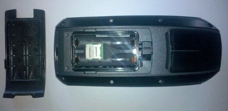
It does. I loaded one mapset and renamed it tn-topo.img, then loaded another and gave it a new name too.
GPS Fix has done a tear down and verified that the chip is an STM Cartesio: http://www.gpsfix.net/gpsmap78-internal-2/
Are the alert/warning beeps louder than the oregon series?
It seems slightly louder, but not much.
It seems like there is a significant difference between the 78 and 62 in terms of external power. The 78s uses a 4-pin round plug, like the 60/76, and seems to be able to be wired directly to a 12VDC supply, so I’m presuming the GPS has an internal regulator to accept the usual 8-36VDC input. The 62s uses a USB cable with an external regulator to also allow the cable to be connected to 8-36VDC. From previous experiences with Etrex that needed 3V, the external regulator was a source of repeated failures when used on off-road motorcycles.
Obviously of no consequence to geocachers, but the 60CSx was the GPS of choice for off-road bike use, and I’d guess many users would expect the 62s to use the same power supply arrangements. I was going for the 62s but may need to change to the 78s (even though I really prefer the look of the 62).
Can you check your 78s and confirm my assumptions, please?
I’d almost bet the 62 also has the 4 pin Garmin plug just like the 78 for serial connection / power and NMEA 0183 out.
Did the answer below tell you what you needed or is there something you want me to check on the 78s? If so, can you be specific about what you want?
I’m OK now, thanks. It seems safe to assume the 78s can have 12VDC applied direct to the 4-pin connector (i.e. there is no external regulator).
The same cable is listed as an accessory for both the 60CSx and the 78 series: https://buy.garmin.com/shop/shop.do?pID=527
I meant the 4-pin connector with the open leads. The 62 and 78 show different cables on their Accessory pages.
The cable with the cigarette lighter plug is harder to decypher as it may or may not have a voltage regulator inside.
Sorry, the 62 series does not have the 4 pin connector, only MCX and mini-USB.
I’m glad I said “ALMOST bet”…..
With the new Oregon (s), I know you have to use a special cable to get NMEA out and that hasn’t worked very well.
The 78 is considered to be a marine unit and needs the 4 pin plug to “drive” connected sounders and such, also radios for APRS applications.
I guess that’s the reason for the difference.
From reading the 78 (and 62) User Manual it looks like Garmin dropped another 60/76 feature that I’ve always used. In Route Setup, I always set my Guidance Method to “Prompted” and Follow Road Method to “Prompted”. This probably doesn’t apply to most users but off-road motorcycling requires to use all 3 different types of routing so “Prompted” makes it easier to use the right type on the fly. Needing to go back to System Setup will be a pain.
The Manual is very brief so I hope this is just an oversight.
Regarding to a screenshot on GPSFIX there IS a prompted-option
http://www.gpsfix.net/wp-content/uploads/2010/06/Prompted-Navigation.jpg
Thanks – that’s good news for me.
Custom waypoint symbol support (as in the Oregon 450/550 models)?
Unsure. How would I check that?
You have to mark a waypoint then go up to change the symbol.
I just tried it on mine (after transfering some custom symbols from my 550 to a newly created “Custom Symbols” folder under C\Garmin)like the instructions on an Oregon.
I don’t see any new “Custom” windows/pages of symbol choices available, so I “don’t believe” it supports custom symbols at this time.
http://garminoregon.wikispaces.com/Custom+Symbols
LP,
I have some custom symbols as described in your link above on my Oregon. However, when I copy some of them to the new 78s I do not see them. I duplicated the file placement on the 78s as on my Oregon, but no new symbols are visible.
That’s a disappointment – hope they fix that quickly.
Check out a long post over on GPS Review I made concerning track drift on the 78S
Where? Mine doesn’t drift so far. It makes the best tracks i have ever seen (Lock on road is off )
)
Thanks Grasscathcer. It’s at http://forums.gpsreview.net/viewtopic.php?t=19567. Feel free to drop relevant links anytime. They’re moderated but I will approve them.
How far was the drift? FWIW, I haven’t noticed anything like this.
Rich,
How can I attach a gpx file?
You can see all three tracks and use whatever software to analyze.
Contact me at my e-mail and I’ll attach it to a reply.
Okay, hopefully this will work. If successful, here are Grasscatcher’s tracklogs for download. I believe you’ll be able to separate them out if you open them in MapSource:
http://gpstracklog.com/gpx/Wedding%20Canyon%20Combo.gpx
http://gpstracklog.com/gpx/Wedding%20Canyon%20X3%20%20June14.gpx
And his comments:
“Attached are two files….one is my ongoing “master file” (16 tracks) just FYI, and the other is Wedding CanyonX3 June 14 and is the latest comparing the 76CSx, 550, and 78S. For someone that can’t separate or isolate individual tracks within the master file , that one would be kinda confusing. It also has in it an older 76CS, and an early 550t.
…but all on the same narrow trail, same direction. (Earliest trip shows some obvious path changes cutting from one leg to the other.)
The X3 file is more on subject. The drift areas are identified by 78S_1 or2 or3.”
Ok. The first drift is one that is not so nice. And for the other 2: Looks like there are very hard conditions for gps signals. And remember: Its release Firmware… It has so many errors… maybe this will be fixed soon.
If we are at the firmware-bugs. Has someone started to make a bug-list already? There are so many, i cant even remember all…
Does the AutoLocate work on your units (i mean, if GPS is set to “demonstration mode” and you press the menu-key on the sattelite-page)?
Georg,
I see that I have the bad areas labeled differently on the two files. Use the X3 file labeling.
Actually, 78S 1 & 78S 3 (most Northerly and most Southerly) are in non problem areas. Or at least haven’t been in the past . Spot 78S 2, I agree, is in a multipath error “problem” area.
Check out the contour lines and the proximity to cliff faces/canyon walls and you’ll see that there are multiple “Testy” places and understand why I use that narrow trail and area for testing.
Maybe it was due to the orientation of the GPS devices. You wrote: “Carried all three units with cases touching each other high on my right shoulder..”
Now, the Oregon and the 76CSX has a quad helix antenna orientated upwards and the Oregon series have a ceramic antenna, also orientated upwards. BUT the 78 series all have a PATCH antenna, orientated SIDEWARDS if you carry the device “high on”. So the 78 may have picked up a less accurate signal compared to the other units.
Maybe this is the reason for the “bad areas”.
Maybe you can retest this by carrying the 78 unit “face up”
FYI:
Oregon:
http://www.pouchx.com/garniak/screens/Oregon400t/Oregon400t_004.jpg
76 series:
http://i36.photobucket.com/albums/e8/KiwiGPS/Inside%2076CS/76CSInsideViews1Large.jpg
78 series:
http://www.gpsfix.net/wp-content/uploads/2010/06/GPSMAP78-Front.jpg
So, there is a big different in the received signal strenght for the 78 series of you carry them all “high on”.
I agree after seeing the results.
Next trip I’ll try carrying it “flat” and exposed as much as possible.
The first trip, was just that…..it’s first trip, and I didn’t want to start out having to “Baby” it any more than necessary. Maybe the next time after that (trip 3), try it with the X ant.
The Oregon with it’s ceramic antenna has proved to work best on that outside shoulder and “facing out” in it’s case.
The 76CSx, with it’s Quad helix antenna, works best (most repeatable tracklog) when an external antenna is used. The X ant (Garmin 25C/27C), which I believe, is a patch type and is usually placed high and flat on a cap brim or pack top. Seems to utilize the chip sensitivity but at the same time reduce multipath error influence vs without X ant. Without X ant, the Q helix is very susceptible to multipath errors.
Anyone notice that with 2.30 update we now have “D’s” on satellite bars when WAAS lock is obtained……
Question: MicroSD card – maximum capacity?
Were you able to try out 16Gb or 32Gb SDHC capacity with the device?
I found that having several maps were great, 60Csx were great, but had to carrry several chips around, which is a pain. Being able to stick 20Gb of maps onto one chip would be sweet.
I did not. I’ve seen reports of people using 16 and 32 GB cards on the Oregons though, so I would think they would work.
Hi…just in market for a GPS. What in your opinion do you consider the best model for kayaking? Thanks.
The 78s is awesome if you need a model that will float. The Montana series has a nice big screen. Both of these are pretty pricey though. I would definitely go with one of the newer Garmins that can use BirdsEye aerial imagery, which seems ideal for kayakers. If you want a good budget option, I’d hold out for the eTrex 20, due to be released in a couple of weeks. Hope that helps.
Will do. Thankyou very much as it does help.
hello gpsmap 78 I dont spend a lot of time with it butt… how do i delete waypoints. delete portions of tracks stop tracback
I’m going off my 62s, but it should be pretty similar…
To delete a waypoint, go into the waypoint manager, select a waypoint, press Menu then Delete
You can’t delete a portion of a track using the 62s. You would have to load the track to a desktop program like Garmin BaseCamp and edit it there.
If you are actively navigating a tracback, pres Find and then Stop Navigation.