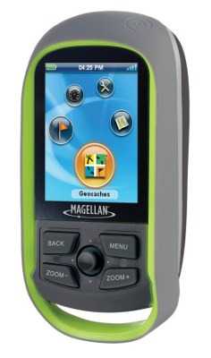
Hands on with the Magellan eXplorist GC
The Magellan eXplorist GC is a new introduction designed to do one thing well – geocache! It has a 2.2” color (non-touch) screen, 18 hour (rated) battery life and a highly detailed worldwide basemap. And while it isn’t designed for backcountry navigation, it can accommodate 500 waypoints and a 5,000 point tracklog. Really though, the eXplorist GC is a one-trick pony aimed at geocachers, with a low and sure to be discounted MSRP of $199.99.
Quick links
More Magellan eXplorist GC reviews
Magellan eXplorist GC resources
How much does it cost?
Related model
- The eXplorist 310 adds more backcountry navigation features
UPDATES
I’ve got several updates to add:
- “Send to (Magellan) GPS” functionality is live
should be live on geocaching.com the week of April 5 - As noted in the comments, it’s a lot easier to get to geocache descriptions, hints, etc., than I said
- I’ve also been told that Magellan is working on a lighter colored background that should improve legibility in bright sunlight
Paperless geocaching
The eXplorist GC is set up for paperless caching, allowing you to have all the relevant information (difficulty, terrain, description, hint, recent logs, etc.) in your hand without needing to print out reams of information from geocaching.com. That’s a common feature in the Garmin Colorado, Dakota and Oregon series, but this unit goes even further. The eXplorist GC lets you filter caches, similar to the way the Lowrance Endura series does, as shown below:
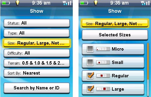
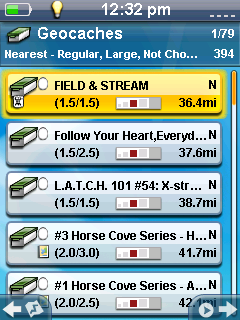
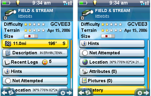
Perhaps the best way to show the extensive geocaching features of this unit is with screenshots, so I’m including quite a few. A filtered list of caches is shown at left. Below, you’ll see the detail screen for an individual cache.
Loading caches
A 30 day premium geocaching.com membership is offered with purchase of the eXplorist GC. It appears that geocaching.com will soon have a Magellan option for sending individual caches directly to the GC, though that is not currently available. I was able to drag pocket queries to the eXplorist GC using Windows Explorer without any problem.
Pre-loaded caches
Promotional literature says that the eXplorist GC is “pre-loaded with the most popular geocaches in the world.” The unit I tested had 1,000 worldwide caches on it. And they really do seem to be the most popular — there were no caches for the 500,000 population metro area I currently work out of, but there were several caches for a theme park 70 miles away! The pre-loaded caches here are a minor attraction. This is not a Geomate.jr type unit.
Navigating with the eXplorist GC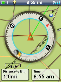
The map can be viewed with or without a compass superimposed on it. The former is shown at right. To access this feature go to Map > Menu. The third choice toggles between Map and Map + Compass.
The compass can be set for smart or standard mode (Tools > Settings > Map Options > Current Location Icon > Smart Arrow). In Smart mode, the compass arrow will change colors – green means on course, yellow means off course and red means that you are moving away from the destination.
One downside here is the use of a standard rather than electronic compass, meaning that you need to start walking before the compass can accurately register the direction to the waypoint.
Accuracy was comparable to other high-sensitivity units. I tested the eXplorist GC side-by-side several times with the Garmin Oregon 450. Generally, at the cache, the units reported within one foot of each other.
Other navigation capabilities
The Magellan eXplorist GC supports waypoints and navigation to them. A record of your track can be displayed and downloaded. There is no provision for routes (multi-destination routing) or track navigation. Waypoint projection is supported (manual bearing entry required; no sight n’ go). I’ll also note that when I dropped a GPX file into the waypoints folder, the waypoints showed up on the GC but their names did not!
I asked Magellan about other capabilities and was told that the GC “does not support topo maps or turn-by-turn at this time.” It wouldn’t surprise me for those capabilities to be added in the future, to the GC or perhaps a forthcoming eXplorist model. There is no slot in the GC for an expansion card, although according to the specs, approximately 500 MB of onboard memory is available for user data (the unit I tested showed 720 MB).
Magellan eXplorist GC interface
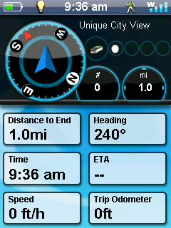 The interface seems relatively intuitive and shouldn’t take too long to get used to. The face of the unit has a click stick surrounded by four buttons – menu, back, zoom in and zoom out. There are five icons on the start screen – geocaches, map, tools, dashboard (shown at right) and waypoints. The number of data fields and their content can be modified for the map and dashboard screens. Input response time was fast in most cases. I noticed a delay occasionally, but not that often.
In some of the geocaching screenshots above and below, you’ll notice icons in the lower left and lower right corners of the screen. The one on the left displays the map, showing your current location, the selected geocache, and a route line connecting them. The one to the right begins navigation.
I’d like to see Magellan clean up the geocaching work flow a bit. Unless I’m missing something, while navigating to a cache, it takes five steps to get back to the description or logs. On the Garmin Oregon I can get to the description in one step and the logs in two.
Magellan eXplorist GC basemap
While there are no topo maps on the eXplorist GC, it appears to have an incredibly detailed basemap. A spot check of locations around the globe indicates that it probably has the entire NAVTEQ road network pre-loaded. Very nice!
Magellan eXplorist GC hardware and build quality
The unit is nice and compact, weighing in at 5.2 ounces with batteries. It’s rated IPX-7 in terms of waterproofness. The battery compartment and USB port seem well sealed. It uses a standard (non-proprietary) mini-USB cable. There is no memory card slot. The eXplorist GC feels solid and is easy to operate with one hand; the buttons all seem quite responsive. Perhaps the biggest surprise on the hardware front is the inclusion of the time-tested SiRFstar III chipset, which manufacturers have recently been avoiding like the plague, due to patent issues.
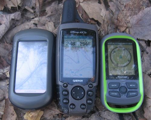
The image below compares the size of the Garmin Oregon 450, Garmin GPSMAP 60CSx and the eXplorist GC. It is not intended to compare brightness, which is very hard to do on film. A discussion of that subject follows.
Magellan eXplorist GC display
I was expecting a very bright display since this isn’t a touchscreen model. But touchscreen units like the Garmin Oregon series suffer more due to their high-resolution display than from the touch screen layer.
The GC’s specs state that it has a 240 x 320 pixel resolution display. They don’t give screen dimensions other than diagonal, but my measurements (34 mm x 45 mm) gave me a count of 50 pixels/square millimeter. I checked this because the more I used it, the more questions I had about the display. This is quite high BTW; the Garmin Oregon comes in at 40 pixels/sq. mm.
While brightness isn’t the only issue at play in legibility, I will say that it is comparable to my Garmin Oregon 400t and 60CSx in the shade. The GC is at its weakest in full sun, likely due to the high-resolution screen resulting in less reflected light. Like the Oregon, it’s fine if you get it at the proper angle, which shouldn’t be too hard for geocachers since they hold it in hand. Users will soon find that they intuitively tilt the unit for optimum display.
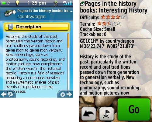
What’s worse is legibility. Magellan has simply used too small of a font (to compensate for the small screen size) for my aging eyes. While the display is fine in shade or indoors, text is too difficult to read in bright sun. To give you some idea of this, the image below shows a cache description from the eXplorist GC on the left and Garmin Oregon 450 on the right.
Pricing and availability
The Magellan eXplorist GC carries an MRSP of $199.99 and is expected to be available in April 2010.
Magellan eXplorist GC pros
- Paperless geocaching
- Geocache filters
- Intuitive interface
- Focuses on doing one thing (geocaching) well
- Awesome preloaded worldwide basemap (roads)
- USB (non-proprietary) interface
- Innovative compass features
Magellan eXplorist GC cons
- Difficult to read in bright sun, especially so for text
Too many steps to reach geocache details while navigating- Occasional lags in menu response
- Not very suitable for backcountry, non-geocaching use
- Lacks advanced features (electronic compass, Wherigo, touchscreen, topo maps, ability to load aerial imagery)
Recommendation and conclusion
At $199.99 MSRP, the Magellan eXplorist is the lowest cost paperless geocaching GPS receiver on the market. I have no problem recommending it as an entry level unit in that arena, though folks over 40 may want to think twice and check it out under bright sun before taking the plunge. This is the best handheld introduction Magellan has offered in years. My biggest issues with this device, font size and work flow, can both be fixed with firmware updates and I’m hoping Magellan will do so. They could have a real winner on their hands if they do. And if my suspicions are correct, we may soon see new eXplorist models with expandable memory, topo maps and turn-by-turn routing.
UPDATE: A reader points out that there have been significant firmware and interface improvements since this review was posted.
More Magellan eXplorist GC reviews
- This Magellan eXplorist GC review shows more screen shots and has a section on file structure
- Geocaching Podcast has posted a “first looks” Magellan eXplorist GC review
- A “first impressions” review of the eXplorist GC has been posted at Groundspeak, the geocaching.com forum
- CNet gives a 3-1/2 out of 5 star rating in their eXplorist GC review
- Darren Osborne reviews the eXplorist GC
- Northeast Hunting has posted a review of the Magellan eXplorist GC
- Geek.com reviews the eXplorist GC
- Tom’s Hardware reviews this dedicated geocaching model
- Larry Fire has posted his own Magellan eXplorist GC review
- Geocacher-authored eXplorist GC reviews at geocaching.com
- The eXplorist GC gets reviewed by the Huffington Post
- FindYourGeocache.com reviews the eXplorist GC
- Pocket GPS World gives a 7 out of 10 rating in their eXplorist GC review
- 2Wired2Tired reviews it too
- A review by Susan’s Disney Family
- Our Kid’s Mom tries out the GC
I’ll be posting more hands on GPS reviews as they appear, but in the meantime, here are some…
Other Magellan eXplorist GC resources
- A new Magellan eXplorist message forum has already been set up for the GC
- The official Magellan eXplorist GC web page
- A Magellan eXplorist GC FAQ
Compare prices on the Magellan eXplorist GC at these merchants:
- Check the current Magellan eXplorist GC
price at Amazon
- Get the Magellan eXplorist GC GPS
at REI.com, where satisfaction is guaranteed and members get 10% back on eligible purchases
- Find a great deal on the Explorist GC
at BoatersWorld.com


This was an excellent, informative, honest and accurate review! Thanks.
Great review, you hit on a lot of good points. I can, however, save you 4 of those five steps to get you to the cache description. From the map screen, it’s as simple as hitting the menu key. From there you will see Description, Recent Logs, and Hints, as options.
I’m equally as impressed about the communication Magellan has had with their end users, as I am with the product. It feels pretty polished right out of the box!
Doh! Thanks Craig. I’ve updated the review.
Don’t mention it. I happened upon it while torture testing the unit myself 🙂
Could you please post a zoom in to a residential area on the map,I’d like to see if ALL streets are included in the basemap.
I haven’t found a single street on http://mapreporter.navteq.com/ that isn’t included.
I just checked navteq’s mapreporter and their coverage of Hong Kong is very complete and impressive. Having had to make maps for my Explorsit 500, I know how time consuming it can be. However, there is no interactive map for China. Can you comment on the coverage of streets in, say, the city of Guangzhou (as compared to Google map)? Also, mapreporter does not list Japan. Does it have street map of Japan? Thanks.
I checked and it appears that coverage of China and Japan is limited to major highways only.
Thanks for checking. Even though it does not contain street maps of China and Japan, if it contains all the maps available in mapreporter, it is almost worth buying just for the maps, and think of geocaching as a bonus.
Clement
Fantastic device, good review. Thanks!
Quick question… does anyone know how well Magellan GPSrs work with a Mac? Will I be able to just drag and drop pocket queries onto the device once connected via USB, or does this require that I run a software program to access the storage?
You will be able to grag and drop right into the geocaches folder. No additional software needed.
Thanks Craig. It’s always nice to have knowledgeable folks help out answering questions.
Regarding Mac compatibility, has anyone checked if the Magellan unit is sensitive to the hidden files that OS X leaves on the mounted volume? When I connect my Garmin 60Cx as a mounted volume, I have to delete via Terminal the hidden files from my memory card or the unit doesn’t function properly (shuts off randomly, etc.). This is Garmin’s problem, really, but they won’t admit it. Has anyone encountered difficulties with this in the OS X interface?
That’s a good question; I had a similar problem with a sandisk MP3 player. It worked fine if I cleaned things up via terminal, but it was pretty much unusable otherwise.
Ok, you have convinced me, now…
Is there a store where I can walk in and get one today (April 15, 2010)?
You can try Target stores if you have any near you. SOME stores are now carrying it.
Ok, you have convinced me now….
is there a store that I can walk into today (April 15) and buy one?
Thanks Craig,
I was calling all over town and nobody had any. Luckily I got your post before Target closed for the night. The store less than 5 miles away had two in stock!
You rock Man!!!!!!
Let us know what you think!
Well, I went caching with it this weekend and so far so good. The maps are FANTASTIC! We were in a cemetary and the roads inside were on it!!!!!!
No getting lost now. The ten logs per cache do come in handy sometimes too.
The font is a bit small for my eyes, but I can live with that. The accuracy is very good. I need to learn all the little nuances and that will take awhile.
One question, I was caching with friends and one of them tried to download her list to my unit and they loaded as waypoints and not geocaches so that none of the descriptions or hints were available. Any ideas as to what we did wrong?
If I decide to take this back to Target, they will charge a 15% restocking fee, so me the cheapskate will probably keep it. I do think it has a lot of potential and should be the unit for me once I get more familiar with it.
Was it a pocket query / .gpx file?
Oh Rich, you would ask me a tough one! I am a dinosaur when it comes to the geek stuff. Up until a few weeks ago I was using an eTrex Legend and inputting caches manually one at a time! I am working on it, though.
I think it was a .gpx file. She had it in her computer and downloaded it directly into the unit.
I think it was probably my fault in some way and not the unit or my friend.
Basically, I am very pleased with the Explorist GC and intend to keep it. I do also like the downloadable user’s manual. There has a lot of detailed information that I can use to become more familiar with my unit.
Sorry, not meaning to throw you! Pocket queries are available to premium members of geocaching.com, and allow you to download up to 500 caches at a time. It generates two .gpx files; the larger will have all the hints, etc. If it was the smaller of the two, or an .loc file, you would only get waypoints. I highly recommend the premium membership BTW. It’s only $3 / month or $30/year.
You also get a month free premium membership with the GPS. Try it out, it is well worth the 30/year.
I have to admit, with all the great talk about this unit I was really expecting a better unit, I’m a little disappointed. I thought something that was made specifically for geocaching would have a built in compass at the least.
While wondering through the woods if there was any cover at all I would lose my satellite signal completely and once out of tree cover would have to turn off the unit and turn it back on and wait about 5 minutes.
Also the menu navigation is a bit clumsy. I should be able to hit back from the map screen to go back to the description (which is where I came from) instead of having to hit the menus, instead it takes me all the way back to the main menu.
Most of the issues like the reviewer said could be fixed easily with a firmware update which I hope will come soon. In the mean time, I’m hoping I was just in a bad spot when I kept losing my signal, even though my old iphone was able to get a signal just fine in the same location. I’ll try it again this weekend in a different spot and see how it goes, but for a 200 dollar dedicated unit, I would expect it to work a LOT better than my iphone.
– Missing Linke
That doesn’t sound right. Has it fully acquired almanac data?
Hello rich,
I will be honest.. No idea what that means. I didn’t see anything in the manual that said I had to download or calibrate anything.
Missing_Linke
Sorry. When you first turn on a new unit, it will often take quite a while to lock onto satellites. It may help to let it sit undisturbed, under open sky, for 20 to 30 minutes. This will allow it to acquire information about where satellites should be located in the near future. This should speed lock any time the unit has been turned off or loses satellites. If your unit sits unused for a couple of weeks, and you are having performance issues, this is one of the first things to try.
Now if you’ve used it for say, an hour continuously at some point since receiving it, without issue, this probably isn’t the problem.
Howdy Rich,
I have been reading the on-line owners manual to learn how to use my Ex-GC.
I have a question. I should be able to delete geocaches and the manual shows that there should be a DELETE GEOCACHE option just above the DELETE ALL option. But on my unit that DELETE option is not there, just the DELETE ALL one. What’s up, can you help?
Sorry, but I’ve sent my review unit back to Magellan. You might want to ask at http://forums.groundspeak.com/GC/index.php?showtopic=244725 or http://www.exploristforum.com/index.php?option=com_kunena&Itemid=62
how do load my devices softmware 1200 roadmate magellagan with amaps
Are you trying to update the software or the maps?
I need help.
I cant figure out how to backtrack my path when in the wilderness.
I heard its called “bread crums” but I dont see anything about it in the manuals….
thanks
steve
There’s no backtrack feature. This is not a good backcountry device; it is designed for geocaching.
From Magellan support…
The eXplorist GC has a track feature that allows you to record and view an area you traveled on your PC. However, it does not have a backtrack feature that can automatically create a backtrack route.
NOTE: The Display Track setting is off by default. To allow track to be displayed select Tools then Settings then Track. Under Track there will be a Display Track option.
I bougth this one, in USA was great, but in China or Central or South America there’s no maps, so there’s is an useless, heavy piece of s…
Hi,
I’d like to ask about two features.
1) On Magellan webpage there is information that this device supports NMEA protocol through usb. Does someone test it? I know that it is made to geocaching but I’d like to use it on boat sometimes
2) Can I choose nautical miles and knots in settings to display?
best regads,
Camel
If nobody here answers, you might want to ask at http://www.exploristforum.com/index.php?option=com_kunena&Itemid=62&func=showcat&catid=13
Thanks for suggestions 🙂
I am considering the Magellan eXplorist GC or the Garmin eTrex Venture HC
for Geocaching with my 4,6,and 8 year olds. Any advice as to which one is the way to go?
I’d say the Magellan, since its designed specifically for geocaching and offers paperless caching features.
Can my Magellan eXplorist show me as I’m walking through the woods the coordinates?
I need it for hunting. How do I do it?
The eXplorist GC doesn’t have much in the way of navigation capabilities. It is a geocaching unit, a one trick pony. Better choices in the series would be the eXplorist 510, 610 or 710.
I did just purchase this unit and I am trying to dl caches to my gps using my mac. Is it compatible? I have been trying for two hours now. I have downloaded the “magellan commuincator for macs” but it keeps saying additional plugins are required. I have tried everything I can think of. If I can’t get the caches onto the unit it is useless to me since what I have is a mac.
If you are a premium member of geocaching.com, you can run a pocket query or download single caches as a .gpx file. Then just drag and drop the .gpx file to the unit while in mass storage mode. A 30 day premium membership is complimentary with the purchase of this unit….
“Magellan: A free trial insert should have been included with your GPS device. Log into your account and visit http://geocaching.com/freetrial.”
I have an iphone4 and have been using it as my primary Geocache unit. If I buy the magellan eXplorist will I achieve better accuracy? Is it worth the hundreds of dollars?
What kind of accuracy are you getting on your iPhone? You can probably find the eXplorist GC for around $150 BTW.
Hi, I live in Spain on the costa Blanca and alot of the Geocache’s are up on trails and short hikes up mountains, will this effect the efficiency or would it be fine to deal with these type cache.
Thanks.
I’m not sure what you mean by efficiency. Do you mean accuracy?
Have the two items you mention as needing a fix via firmware ever been corrected?
No idea. Maybe someone else will chime in or you could ask at http://www.exploristforum.com/
I returned the Magellan eXplorist GC after a weekend of failure to get Magellan’s own Mac plugin to work. The groundspeak forums concluded that it doesn’t work and that Magellan has no plans to support the Mac, ever. As I was standing in the return line, I finally saw the 4-point print on the box (not visible before purchase) saying that Windows was required. Fortunately, Best Buy gave me a full refund, with no restocking fee. The returns clerk was as bemused as I at the failure of Magellan to support the Mac.
My question is, since the Magellan is out, what’s the best entry-level GPS to buy for geocaching? A compass that doesn’t require significant forward motion would be a plus in chasing down caches in underbrush.
Ouch!
Well, there isn’t a good alternative with paperless caching support. There’s the Geomate.jr (unsure of their Mac support), and the new Garmin eTrex series coming out next month. Otherwise, things get pricey quick or they don’t support paperless.
Your best bet may still be the GC, but with a premium membership to geocaching.com, so you can do pocket queries and not rely on their plugin.
You mention the new etrex line do you have a release date? I had just bought this unit and I hate to say that my iphone has better accuracy.
Right now I’m seeing September 15.
I’m disapointed with this unit. (Magellan explorist GC) It worked fine the first 2 times I used it. However, on the third outing it failed to get a satilite signal. I mean it won’t get a signal at all. The unit keeps prompring “signal lost, continue looking” but will not find a signal.
At the same time and location my buddies phone gets a GPS signal with 4 bars. So the signal is there. I should have downloaded a free app for my phone instead of wasting money on this unit.
How long of a time lapsed between the second and third uses? If it was more than a few days, try leaving it on, motionless, under open sky for half an hour.
A smartphone uses assisted-GPS, getting satellite almanac data from cell towers, while a handheld will take some time to rebuild satellite almanac data if it hasn’t been used in a while.
Thanks for the information. I tried leaving it on as you suggested and it worked. However, If I have to wait 30 minutes every time I want to use it, thats kind of a drag.
Without dragging out the conversation, my job schedule demands that the GPS will be off a few days at a time between every use. Any ideas about that?
I allready downloaded the 1.7 software
Good deal. A few days really shouldn’t matter. If it’s been weeks, expect it to take awhile.
I find that it’s harder to get a satellite lock when moving, so if it’s been awhile, that will make it worse.
Usually, even if it has been awhile, a few minutes on at the trailhead, or in the window at home before departing, is all that is needed.
ok great. Thanks for the information and help
Hi there,
I started geocaching (hunting) using an iPhone 4, and mainly suffer of 2 problems that make me think at buying a true GPSr :
– too short battery life
– accuracy
I guess the Explorist GC will solve my battery life problem.
On the other hand, I do not have any idea if accuracy will be better than with my iPhone.
Moreover, I also plan to place my own caches, and I wonder whether this GPSr will help me in that. Does it allow to view/save/read back coordinates? Does it feature any kind of waypoint averaging option? Does it have any specific mode made for geocaches hiding?
Thanks for your feedback,
oliantoine
I don’t know if it will be more accurate or not. Generally you can expect accuracy of 10-30′ from a handheld GPS, depending upon conditions.
According to the manual, it has a waypoint averaging function.
You might also look at the new Garmin eTrex 20.
Can tell you how excited my dauther was on her birthday. We open the package together and went to set it up….and it would not turn on. We had to wait 3 day to call tech support and they determined that it needed to be replaced.
That sucks. I’d be interested in hearing what your experience is from here on out with it.
I received this unit from a friend but didn’t have the book with it or the usb cable. Any idea where I can get an instruction book and a cable?
http://support.magellangps.com/support/index.php?_m=downloads&_a=viewdownload&downloaditemid=125&nav=0,18,24,62 for the manual. Reading the review above might be helpful too.
It uses a standard mini-USB cable, which you can find online or at Radio Shack.
Love this unit and recommend it to any new geocacher. As I mentioned in the review, which you’ve kindly linked to above, “it is excellent value for money and should appeal to most newish geocachers, particularly those wanting to jump into the paperless geocaching realm.”
I bought this unit recently and just tried it out today alongside my iPhone running Groundspeak’s geocaching app. I have to say I much prefer the iPhone. I was hoping for less “bounce” but found it to be about the same. Accuracy about the same also. What pushed my favor to the iPhone app was the ability to search “on the go”. I found out that I really, really dislike having to download caches.
Thanks for taking the time to post a review and rating. FWIW, using pocket queries (requires a premium membership at geocaching.com) reduces the painfulness of downloading caches.
I REALLY loved this GPS. I would highly reccomend it for anyone. EXCEPT, today – the middle button that is used to move around and select, etc just randomly stopped working. OF COURSE all my warranties expired [ 🙁 ] and so being the stubborn person I am I decided to take this gps apart [even though the magellan person told me, once the center thing is broke – it’s definitely broke]. After taking at least 15 screws out to get to the center part, YEP – he was right. Once its broke, its broke. So, sad to say, but I guess I will be purchasing a NEW Magellan GC to replace my broken one; hopefully it will not have the same problem as it is only 15 months old…
Ouch! Maybe it’s worth getting an extended warranty on the next one.
Hi, I would like to pint that they have recently updated the firmware of this device to version 2.15.
The menus are a LOT easier to read and the UI had improved a lot. If possible, you might want to update this review as a lot of the negative comments seems to be corrected. It seems that they listened to the users!
Thanks JB. I’ve linked to your comment in the Conclusion section of the review.
Hi. You should update your review. With new firmware ver 2.15 eXplorist GC can work with detailed vector maps and with raster maps (scanned topo maps, satellite imagery etc.) You can also install “hacked” firmware from 310 model to enable more map and track features.