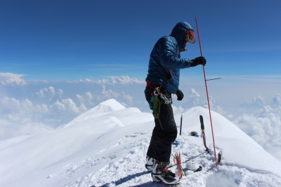
Blaine Horner of CompassData probing the snow pack at the highest point in North America along with setting up Global Position System equipment for precise summit elevation data. (Photo: Blaine Horner, CompassData)
It’s easy to forget that GPS technology is still fairly new, all things considered. Before this technology became as accurate and simple as it is now, surveyors had various other methods for measuring things like distances and heights. While it’s tempting to tout our newfangled tech and say that it’s the best, it turns out that the 1950s era technology that originally measured the highest mountain peak in North America was actually only off by 10 feet.
Mount Denali (formerly known as Mount. McKinley) was measured by surveyors late last month and the results are officially in. The official height is measured at 20,310 feet which is still pretty big and definitively the highest point in all of North America.
The Alaskan peak has been a point of controversy not only for its height but also the name. Formerly named Mount McKinley for the shortest american president (who coincidentally never visited Alaska) current President Barack Obama recently officially sanctioned the name change back to Denali, the name taken from the native Alaskan population.
Mount Denali has actually been measured several times since the original 1950s measurement was taken, including most recently in 2013 when the height was found to be 20,237 feet. That measurement was taken by airborne radar measurements but was under suspect as the equipment is not generally very good at elevations. The most recent technology was done using precise GPS surveying equipment. You can read all about the journey on the US Geological Survey website.
Of course, while Denali losing 10 feet is a little saddening to some, at least the majestic mountain didn’t suffer the same indignity as Snowdonia did earlier this year in South Wales. The former mountain was remeasured using more accurate modern technology and discovered to be 23 mm too short to be considered a mountain. Much to the dismay of locals, it was downgraded to a hill. A really, really big hill. Maybe that will
