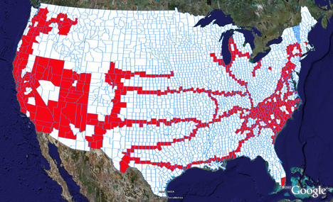
Years ago, long before I got my first GPS, I came across a map of U.S. counties, and I started using it to record my travels. Over the years, that map became tattered and torn — "loved to death" as it were. Paper versions are still available, but it really needed to be replaced by the digital variety. So I was thrilled when Free Geography Tools recently wrote about Color Your Map, which allows you to color countries of the world, U.S. states, or counties within a state, and view them in Google Earth. So I assembled 50 files; you can see the results of 48 of them below.

A map like this can tell us so much about our lives. The image above speaks to my youth in NC, a decade old move to the west coast, some Interstate road trips, a love of the southwest, and an unforgettable trip to Big Bend where I fell in love with the woman who would become my wife.
I learned some geography in putting this together too. I discovered that Louisiana’s St. Martin Parish is split in two, due to an 1868 surveying error. What I didn’t learn is why Color My Maps makes it look like Vermont has 249 counties when the Census Bureau says it only has 14!
Granted, this may all be a little obsessive, but I had fun doing it. And that’s what counts.

Ok, now I must find time to do this.
Good to hear from you again Zack! It didn’t really take all that long. Of course, I had a paper map to go by that laid out most of the counties I had visited. That helped.
Seems cool but it might take a while. I track everything I blog about on a map on my website ( http://seanhenri.com/map.html ). I’m thinking about adding this on there. Thanks for pointing it out!
Paint by Counties
tags:
The 295 counties Ive found a geocache in so far. 2007-07-29
Ive always loved traveling. Growing up in a family of educators meant that I did quite a few of the color the states youve been to type activities wh…