Sunday, March 18, 2012

Open Source Tracker Blazes Past Kickstarter Goal

hidnseek

In writing for this blog for nearly a year, I have covered all kinds of Kickstarter projects, some of which have funded and successfully launched to pretty decent reviews, like Trax. Others completely flopped, as is the danger with crowdfunding anything, especially anything involving technology. As a general rule, I tend to wait until projects are completely or nearly completely funded before even bothering to write about it. And, as it turns out, HidnSeek is one such project. With five full weeks left, this tracker has blasted through it’s modest goal and continues to receive funding.

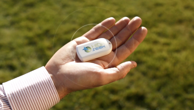
At the surface, HidnSeek really isn’t all that different from, well, any other GPS tracker. The device is small and designed to be slipped into a pocket, bag or clipped on a zipper or keychain. It can record and transmit location once every five minutes (longer periods of time are allowed) and supposedly has some pretty good battery life if you don’t mind less frequent pings. HidnSeek also supports motion sensing and geofencing, as you would expect with a tracker.

However, HidnSeek does have a couple of things going for it that are slightly unusual. read more

US Government To Test eLoran as Backup

FP_Satellite_icon

GPS jamming threats have increased in recent years, so much so that the United States Government has been looking into alternative methods of ensuring that navigational technology can’t be competely disrupted. The most common solution to the GPS jamming threat has been to simply develop a backup system. And that backup system would be eLoran.

We’ve talked about eLoran a few times before, and the United States Department of Transportation recently put out a call for citizens to comment on the possible use of it as a backup system (or to offer suggestions for other backups). The commenting period has concluded and it seems that there must have been some pretty positive responses because the United States Deapartment of Homeland Security and the US Coast Guard recently entered into a cooperative research and development agreement (CRADA) with Exelis and UrsaNav to test out the viability of eLoran as a backup. read more

System Allows Drones to Fly Without GPS

GPS drone (UAS) with GoPro camera

GPS drone (UAS) with GoPro camera; Creative Commons image courtesy Don McCullough

Drones are absolutely taking off in popularity and public appeal (pardon the pun). In the wake of the FAA finally releasing rules and regulations for drone use, it seems like the whole world has suddenly become drone-crazy. But, with companies like Amazon promising that drone deliveries are just around the corner, researchers are looking fore newer and better ways for drones to get around in cities where GPS isn’t always super reliable. read more

Supermarket Uses LEDs for Indoor GPS

indoor location

I’m not really 100% sure why, but for some reason or other everyone seems to be rather obsessed with indoor location technology, specifically for commercial use. I can’t say that I’m not interested in anything that avoids me having to walk up and down every aisle looking for black olives (which are always placed somewhere strange), but the indoor location technologies most places pitch just seem far fetched and less than helpful. Many of them involve Bluetooth as well, which is not only costly but requires Bluetooth to be on which sucks down my smartphone battery. There just isn’t really an elegant fix for indoor location technology right now.

Well, Philips, a company that focuses on innovation in various lifestyle areas, thinks it might have come up with a solution. Using advanced LED lights which transmit not only illumination but also codes that provide location information. Then, using the same basic ideas that spawned the GPS system, Philips has designed a navigation system that could help customers find their way around a supermarket or other indoor location. read more

Amazon Files Drone Patent, Gets FAA Permission

Amazon GPS drone delivery

In December of 2013, Amazon announced that it was working on allowing drone deliveries to Prime customers within an half hour of order. It caused quite a stir on the internet and most customers were as excited as the Federal Aviation Administration (FAA) was condemning. However, after much debate and posturing on both sides, apparently the FAA has decided that letting Amazon test drones in the US wasn’t really going to hurt anything.

FAA Exemption

The date on the exemption is actually listed as early April, so this is slightly old news. However, as the FAA has spent many public meetings stating that it wasn’t a huge fan of this idea, it’s definitely a step in the right direction. Amazon, however, can’t be 100% happy as the exemption did come with a few restrictions; at least one of which is extremely problematic. The FAA is allowing Amazon to test out its drones as long as: read more

Affordable Centimeter-Accurate GPS Developed

wedsacx

GPS technologies are constantly improving and expanding. When first launched, GPS provided accuracy within several hundred feet. Then, when Selective Availability ended, accuracy skyrocketed literally overnight to a few meters. Now, a research team at the Cockrel School of Engineering at the University of Texas at Austin has found a way to increase that accuracy to a few centimeters without increasing the cost. The catch is that this new technology was funded by Samsung and therefore is designed specifically for smartphones.

I know what you’re probably thinking. Centimeter-accurate devices are already available right now. IN fact, centimeter-accurate positioning devices are commonly used in several different fields including geology, mapping and surveying. However, these survey-grade antennas are a too large to use with a mobile device, and the antennas and equipment is pretty expensive. The researchers wanted to create a super accurate system that was affordable so that everyone could use it. read more

The Geotagger’s World Atlas

London map

Every city has something unique about it, whether it’s a memorial statue, a cool coffee shop, a world-renowned museum or a local pizza parlor. These places are visited by hundreds or maybe even thousands of people a year, which translates to dozens of photos, many of which are geotagged to show the location of these popular and special places.

So, what would happen if you took all of those photos and created a map, linking the photos to show individual journeys and locations? Well, you would end up a neat sketch-like image of the location, filled with individual travels and popular locations. You’d get the Geotagger’s World Atlas. read more

Poll: What Kind of GPS Do You Prefer?

FP_Satellite_icon

Next week, on April 27 to be exact, the United States GPS system will be celebrating it’s 20th anniversary of Full Operational Capability. During those 20 years of service, the system has been made widely available to the public via the end of Selective Availability and has been improved with new satellites. As more and more technology has begun to rely on GPS, the numbers and kinds of devices that use this constellation has increased almost exponentially.

Here at GPS Tracklog, I try and cover as many of the different segments of GPS as I can, from automotive to tracking to fitness and even marine on occasion. But, as the industry continues to expand it made me start to wonder: what kind of GPS do most people actually use on a regular basis? With smartphones offering surprisingly accurate maps, are automotive GPS devices really on their way down like the statistics predict? Does anyone actually use trackers on things? Do you even care about fitness GPS devices? I know I don’t really like them much.

So, today I thought I’d put it to you, fellow GPS enthusiasts. What kind of device do you prefer? Is there a particular kind of GPS you use on a regular basis, or many? Cast your vote in the poll and see where you stand! read more

Galileo Approves new Search and Rescue System

Search and rescue helicopter

Search and Rescue is one of the less obvious uses of GPS


When most people think about satellite navigation uses, the first things that come to mind are probably location tracking and navigational directions and instructions for traveling. But, what you probably aren’t even thinking about is one of the more important uses of these satellite systems—search and rescue (SAR) operations.

According to a UPI article, a Honeywell Global Tracking system recently passed the final acceptance test for use with Galileo’s SAR program. The system, which was not named in the article, supposedly can reduce the time it takes to detect and process an emergency signal from several hours to a few minutes. read more

GPS May Be To Blame for Accident

photo by John J. Watkins, The Times

photo by John J. Watkins, The Times

On Saturday, a woman was killed and her husband injured after driving off the ramp of a partially demolished bridge in East Chicago. According to NWI, who covered the incident, the bridge had been closed since 2009 and had orange road closed signs and concrete barriers to indicate that the bridge was no longer in service. read more