and Magellan Meridian Platinum
side-by-side to check for accuracy in a canyon. Canyons, both natural and urban are notorious for the phenomenon known as multipath — the reflection of signals off canyon walls. GPS receivers work by calculating the time it takes for signals to be received from GPS satellites, so signals bouncing off canyon walls are delayed slightly, thereby introducing error.
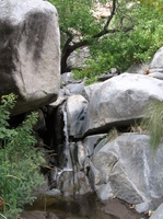
The test was conducted in Sheep Canyon (picture at right), in Anza Borrego Desert State Park. Sheep Canyon is not a tight slot canyon, but it is a canyon nonetheless. I must have had good satellite coverage, because I never lost the signal lock the entire day.
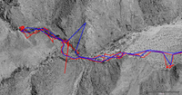
 To see visual evidence of the difference between reception in the two units, check out the tracks on the aerial photo to the left. The Garmin track is in red, the Magellan in blue. I have one caveat here…It appears that the Garmin collected much more detail, but the Magellan is my wife’s GPSr, and I’m not as familiar with it. Once I saw this image, I checked and discovered that the Magellan was not set to acquire as detailed of a tracklog as possible. Apart from that, the most interesting thing I see is that both units recorded at least one stray track point, far away from our position. On the basis of this, I’d rate their performance as comparable.
This canyon wasn’t tight enough to reduce reception much, but the topography did contribute to the stray track points. You can visit my other website to see the entire tracklog and geocoded photos, and this page on GPS Tracklog provides more information on geocoding photos with TopoFusion. Finally, stay tuned; over the next week or so I’ll have some more posts related to our GPS vacation.
