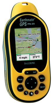
Hands on with the DeLorme Earthmate PN-20
UPDATE: There are now two newer models in this series, the DeLorme PN-30 and PN-40.
Finally, a GPS that displays aerial photos. The DeLorme Earthmate GPS PN-20 does just that, and displays USGS topo maps too. It is incredibly cool to be carrying a GPS that shows your position on an aerial photo. Having said that, DeLorme clearly has some improvements they need to make, and I hope they do, because this is one nifty device. Before we get into the details, let’s get up to speed on aerial photos, and why other GPS receivers lack this capability.
Aerial photos on the DeLorme Earthmate PN-20
Most GPS receivers utilize vector files — basically data files consisting of lines and points. The DeLorme PN-20 differs in that it can also accommodate images, such as aerial photos and USGS topo maps. The technical term is raster imagery, and they eat up much more memory than vector files. For a more detailed explanation of raster versus vector imagery, see What kind of maps can I put on my GPS (and what do you mean by raster and vector)?
Vector lines are redrawn, and therefore appear sharp, at every zoom
level. Aerial photos and USGS topo maps, on the other hand, will only
appear clear at one zoom level. DeLorme probably uses aerial photos
supplied by USGS which are available at multiple resolutions – 1
meter/pixel, 4 meters/pixel, 16 meters/pixel and 64 meters/pixel.
DeLorme appears to be utilizing the one meter/pixel imagery.
Compare prices on the DeLorme Earthmate GPS PN-20
Below to the left is an aerial photo screenshot, showing a logging road / trail in dense redwoods. Beside it, to the right is a screenshot showing a 1:24,000 scale USGS topo map.
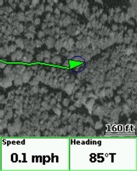
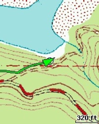
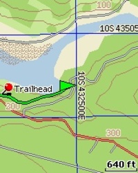
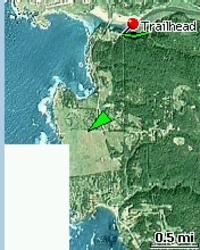
To the left is a screenshot that utilizes vector files generated from Topo USA 6.0. Further down this page are additional screenshots, including one showing color Sat 10 imagery (the section missing is an area that I did not download for transfer to the PN-20).
Unfortunately, the aerial imagery comes at quite a cost. You download it from DeLorme at $0.25 per square kilometer. That may not sound like much, but let’s do the math. The average USGS 7.5′ topo quad covers around 155 sq. km., so the cost would be $38.75 per quad! Holy mother of bankruptcies; I can’t afford to be a map junky at that rate!
The good news is, they’ve dropped the price — it used to be $1 per square kilometer — and, they give you $100 worth for free (400 sq. km.). C’mon guys, gives us some options here. I bet you’d make more money with an annual subscription model like Bushnell.
Finally, before we leave the subject of aerial photos, check out this post showcasing the amazing level of detail that can be seen on aerial photos on the PN-20.
PN-20 pros and cons
First, let’s talk about what’s to like. Did I mention aerial photos? As far as handheld GPS receivers go, that’s close to being a killer app. Beyond that, the DeLorme Earthmate GPS PN-20 has a nice form factor. It fits your hand well and the button and menu layouts seem fairly intuitive. Nice job for a company that is new at all this.
The PN-20 seems to be quite accurate. Compare the tracks in the image at right below. The red track was collected with a Garmin 60CSx with the SiRFstarIII chipset, while the blue is the PN-20. As you can see, they are virtually indistinguishable; the PN-20 did wander a bit once, in the upper left portion of the image, but overall, I was pretty impressed.
You can route along 4-WD roads, even though you are viewing a topo map. That way, you get an accurate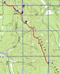 estimate of the mileage to your destination, instead of an “as the crow flies” estimate. The PN-20 comes bundled with DeLorme TOPO USA 6.0, and the company has good, detailed help files to assist you in transferring maps, imagery and data to the PN-20.
The downside
Those help files are a good thing, because DeLorme’s TOPO USA is one of the most convoluted and painful pieces of mapping software I’ve ever seen. Non-intuitive is an understatement. Part of the problem is that they’ve ventured away from the familiar Windows-type program interface and gone off on their own. The learning curve is steep. Despite that (thanks to the extensive help files) the pain is lessened a little. Having said all that, Topo USA does have some advantages, like the ability to create your own routable roads and trails where they are missing from the map– clearly a plus.
There are a few negatives on the hardware side too. The screen is small – 2.2” compared to 2.6” on a Garmin 60CSx, and the processor can be slow, causing frustrating delays of a few seconds in navigating menus (EDIT: I should add that the PN-20’s newest firmware has reportedly improved redraw, scroll and find speeds). I also noticed occasional condensation on the screen of my review unit,
but I haven’t seen this reported in the DeLorme forums, and I’m
assuming it is an aberration. Finally, the estimated time of arrival on the PN-20 wasn’t as accurate as on my Garmin 60CSx.
DeLorme support
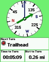
DeLorme had a few hiccups with the initial release. The most significant is that the compass pointed the wrong way during the final leg of a route (or if you simply told it to lead you to a waypoint). DeLorme responded with a fix via a firmware update within days of the bug report though. Many units shipped with battery compartment screws that were barely long enough to function, and a pain in the rear.
More DeLorme EarthMate GPS PN-20 reviews
- Consumer-authored DeLorme PN-20 reviews are being posted at Amazon.
- GPS Review has posted a very thorough DeLorme Earthmate PN-20 review, including a few disappointments.
- Backpack Gear Test has posted a Delorme PN-20 review.
- A lengthy thread / DeLorme Earthmate GPS PN-20 review has been posted at Groundspeak, geocaching.com’s message board.
- The Washington Post has published their own DeLorme Earthmate GPS PN-20 review.
- PC World gives a rating of 84 — very good — in their DeLorme Earthmate PN-20 review.
- Here are a couple of consumer-authored DeLorme PN-20 reviews.
- A DeLorme PN-20 review from a GIS professional’s perspective.
- A geocacher reviews the DeLorme PN-20.
- Another personal DeLorme PN-20 review.
- A marine take on the PN-20.
- About.com reviews the DeLorme PN-20, giving it a 4 out of 5 star rating.
- A brief but negative DeLorme PN-20 review.
- Stonekettle Station reviews the PN20.
- Peterson’s 4 Wheel & Off-Road Magazine reviews the DeLorme PN-20
- TheGeocacher.com has posted a DeLorme PN-20 review.
- A DeLorme PN-20 pros and cons list.
I’ll be posting additional information ASAP. In the meantime, here are some additional…
DeLorme Earthmate GPS PN-20 resources
- The official DeLorme Earthmate GPS PN-20 web page.
- A PDF version of the DeLorme Earthmate GPS PN-20 owners manual.
- A PDF DeLorme Earthmate PN-20 FAQ.
- A DeLorme Earthmate GPS PN-20 message forum.
- Over at GpsPasSion, they are discussing the DeLorme PN-20 firmware version 1.2.
- Hidden features of the PN-20, just one of the posts you’ll find at the DeLorme blog.
- Geocaching tips for the PN-20.
- And a tip for finding caches along a route.
- DeLorme has posted a YouTube video on how to use the PN-20.
Compare prices on the DeLorme Earthmate GPS PN-20 at these merchants:
- Check the current DeLorme Earthmate GPS PN-20 price at Amazon.
- Buy the
DeLorme Earthmate PN-20 GPS Bundle with Card and Reader
at REI, where satisfaction is guaranteed and members get 10% back on eligible purchases. - Get the DeLorme PN-20 for an amazing price on eBay.


I purchased this unit via their net offer. I was impressed with the unit but had some problems with the software. I also had ordering problems that took several phone calls to correct.
I was going to keep the unit but after speaking to others who had experiences with DeLorme I shipped it back.
The problem wasn’t with the unit it was with their arrogant attitudes. Regardles of who I spoke to or emailed I got the impression that they were doing me a favor by assisting me. This was confirmed by others who actually stopped at their retail store on the east coast.
Bought a Garmin, spent more, but I don’t need to be treated like I’m bothering somebody when I’m spending my monies!
It never ceases to amaze me just how bad companies can be at customer service. I’ve been impressed that DeLorme has their own support forum, but it sounds like they are just downright rude otherwise.
Although I am familiar with the DeLorme Topo software, getting 7 ½ minute maps up and running on the PN-20 was a day-long project. Don’t read the manual because the information you need isn’t in there. Use the on-screen help. If you want to use both the 7 ½ minute and the Topo 6.0 map displays simultaneously, there are some software problems that make route planning extremely frustrating. And don’t even think about using PN-20 without an SD card. You will also need an SD card reader.
Unfortunately, I expected more than the tiny Earthmate display can deliver. The screen is just too small to see much. Zooming in and out is so slow and the display so sluggish that the map feature isn’t of much value except as a novelty. If you are hiking an unfamiliar area you need a paper map as backup anyway and the paper map is more useful.
Comparing it to my old Garmin eTrex, signal acquisition speed is about the same, and the PN-20 is not noticeably heaver, but it’s larger and more awkward to use. The Garmin is designed for one-handed operation. You can keep hiking. The PN-20 requires two hands. You have to stop. And wait.
I wish I liked the PN-20 better, but the hardware needs to be faster and the software easier. The tiny display might be ok if zooming and scrolling were quick, but they aren’t, and the maps are expensive. I’m sticking with the old eTrex.
It’s steve barron again… I was very pleased with how Delorme treated my case. I was charged a very fair price for the repair. I also got it back very fast. I am very pleased!
http://www.gps-tracker.com.ar
[email protected]
Equipos de GPS y Rastreo Satelital – Argentina
Beware! Delorme is openly defrauding consumers on rebate promotions for its products, promising ‘competitive’ rebates to owners of competitors’ products. I was defrauded by CPG, their rebate vendor. When informed, three contacts at Delorme defended the fraud, even though CPG admitted to Delorme National Account Manager Ellen Shaw that the rejections were bogus, and CPG failed to pay. Also, MS Streets & Trips is far more useful to 80% of users, while Delorme charges $$$$ on top of initial retail for ‘maps’.
I’d be interested in seeing what kind of feedback you get if you post this to the DeLorme forums.
The review doesn’t say anything about battery life. I’m just curious for some sort of benchmark relative to the upcoming PN-40
The PN-20 is rated at 14 hours. Here’s what Chip Noble of DeLorme said recently about the PN-40…
http://forums.groundspeak.com/GC/index.php?s=&showtopic=197213&view=findpost&p=3626299