We’ll start this series off with CD (or DVD) -based mapping software to use with (not on) your GPS. In this category, you typically buy a package that has all the topo maps for an entire state, usually for around $100 retail. This is a great deal for your home state, but could get expensive for those with a serious case of wanderlust! Most of these programs are relatively simple to learn, and most produce great printed maps for field use as well.
National Geographic TOPO!
My favorite software in this category is National Geographic TOPO! (Amazon). It is fairly straightforward and easy to learn, and a number of common features are well designed. One example is that you can construct routes from existing waypoint names. You would think that would be a no brainer for the designers of these programs, but sadly, too many software packages lack this feature.
 Other small advantages that end up being very helpful include the ability to split tracks, and the fact that you are automatically taken to the name field when you click to place a waypoint. These are just a few examples from this user-friendly program.
Of course there are downsides to any program; none are perfect. There is no free demo to try, and you can’t view aerial photos in National Geographic TOPO!. Oh, and did I mention poor support?
The worst flaw though, in my mind, is the program’s treatment of tracks. It’s easy enough to get tracks in, but getting them out has been a royal pain. Fortunately, GPS Babel now converts tracks from TOPO!’s .tpo file format.
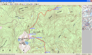
Despite its flaws, National Geographic TOPO! is, IMHO, the best of it’s class. I’ve included a screenshot (above right) of an upcoming trip that I have planned.
Let’s look briefly at a few highlights and lowlights of some other CD- and DVD-based mapping programs:
- DeLorme 3-D TopoQuads suffers from a difficult to learn and cumbersome interface.
- DeLorme TOPO USA gets you all 50 states for the price of one, but they are vector maps that do not resemble your standard USGS quad. It also suffers from the infamous DeLorme interface cited above. Aerial photos are available at a whopping average price of $155 per quad! We’ll look at a much more economical way to use aerial photos in the next post in this series.
- Maptech’s Terrain Navigator produces the nicest printed maps of any program in it’s class. But it is weak on a number of basic features, such as its inability to split tracks and the fact that you cannot start a route or track on an existing waypoint (both of which you can do with TOPO!).
- Terrain Navigator Pro adds aerial photos, but bumps the price to $300 — plus, after a year you need a $100 annual subscription to access aerial photos. And it’s one of the buggiest programs I’ve used, managing to crash multiple computers. I’m going to wipe my hard drive soon and do a fresh install of the newest version, and will report back then.
There are full chapters on each of these programs in my book, GPS Mapping – Make Your Own Maps. Finally, all of the above programs are available at a discounted price at GPSNow.com.
In the next few installments in this series, we’ll look at Internet-based applications that give access to aerial maps, and more comprehensive programs for you power mappers out there with unique needs.
Other posts in this series:
