UPDATE: The nuvi Essential series is already shipping.
UPDATE 2: Read my hands on review of the Garmin nuvi 40.
UPDATE 3: The Garmin nuvi Advanced series is now shipping.
UPDATE 4: Read my First Looks – Garmin nuvi Advanced series post.
UPDATE 5: Read my hands on Garmin nuvi 2495LMT review.
UPDATE 6: Read my hands on Garmin nuvi 2555LT review.
UPDATE 7: Read my hands on Garmin nuvi 3490LMT review.
Thanks to the FCC, we’ve gotten access to the Garmin nuvi Advanced and Prestige series owners manuals, and have been going through them with a fine-toothed comb, looking for new and returning features. Here’s what we’ve learned:
Advanced and Prestige series features
According to the manuals and information released by Garmin, the features listed below are common to the 24×5, 25×5 and 34xx series.
Powered mount- Shortcuts – The Where To? menu can contain up to 36 shortcuts; these can be to locations, categories or search tools
- Report closed or missing locations – This edit option allows you to send feedback on closed or missing locations the next time you connect to MyGarmin
- Edit location info – You can change the address or phone number for a location
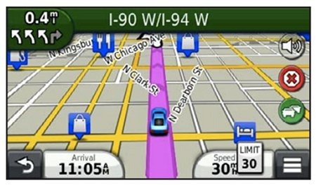
- Customizing map layers – You can customize which data appear on the map, such as icons for points of interest (as shown above) and road conditions
- Changing the tools on the map (also shown above) – “Map tools appear as buttons on the map, which provide quick access to device functions. For example, you can add a button to take a detour, adjust the brightness, or view exit services. You can select up to three tools to display on the map.”
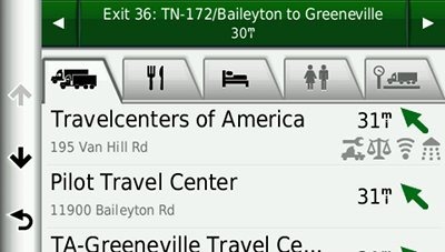
- Exit Services – Similar to similar to Magellan’s Exit POIs, this feature shows you points of interest (POIs) for upcoming exits (screenshot below from Garmin dezl); a very useful feature
- Map dashboard – I’m not sure what this looks like, but it’s a term used in Garmin handhelds for changing the types of information that is displayed
- Apps – Where Am I? is now termed an “app,” as is ecoRoute; here’s a strange statement from the manual regarding the 34xx – “In some areas, an ecoRoute HD accessory is required to use ecoRoute features”
- Last Spot – A new name for an app showing where you last parked
- Where I’ve Been – Also an app, this is different from the Trip Log; “you can view your previous routes and places you have stopped on the map”
- Custom avoidances and Advanced detours – These appear to have made it to all three series (24×5, 25×5 and 34xx)
- Orientation – Screen automatically rotates between landscape and portrait
- Privacy settings – A Position Reporting option says it “allows Garmin to share your speed, direction, and location with other service providers anonymously with your consent”
- Audiobooks – This feature returns, though there is no standalone MP3 player on the 24×5 and 25×5 series
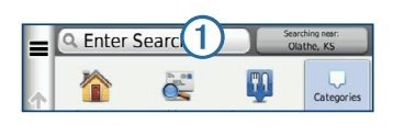
- Search bar – I don’t have a full screen shot, but the image below from the manual shows a redesigned search bar, found on the Where To? menu; you can also see it in the video below
In the following case, the feature is not found on all models in each series:
- Automatic volume adjustment – Based on the background noise in the vehicle. Not available on all 24×5/24×5 models; is found on all 34xx models
You can see many of these features in the following video:
Garmin nuvi Prestige (34xx) series only
- Ability to update speed limits – Hopefully this is a mistake and it’s found on the Advanced series too
- Suggested routes – “Before you can use this feature, you must save at least one location and enable the travel history feature. Using the trafficTrends™ feature, your device predicts your destination based on your travel history, the day of the week, and the time of day. After you have driven to a saved location several times, the location may appear in the navigation bar on the map, along with the estimated time of travel, and traffic information. Select the navigation bar to view a suggested route to the location.”
- Media player –The MP3 player is back, but… “The media player may not be available on all models”
Via the FCC. Follow the links below to read them for yourself, but expect to see a scary security certificate warning:


You would think the privacy settings wouldn’t mean too much unless these were ‘connected units’ which none are.
I think they collect the information when the units are connected to the computer (ie., when you are receiving a map/firmware update). That’s my theory, but I think that’s how they gather their information for Traffic Trends, HD traffic, Updated Speed Limit Info, etc.
Which brings me to my next point. I am glad they are giving the ability to update speed limit info to the 3490, along with customized dashboards and map layouts.
Now, if we can have a true HD traffic coverage map just we can get an idea of how extensive the traffic broadcasts are, then we’d be in shape. The live traffic map on Garmin’s website doesn’t do enough, in my opinion.
That aside, I am seriously tempted to just bite the bullet and order it from Amazon.
That’s a possibility but all the current units collect info for traffic trends and I don’t remember any privacy settings on my 1695.
The BTC stations reach 188 million people with analog broadcasts and 183 million with digital broadcasts so the coverage is slightly less but pretty close.
The 1695 definitely does have a privacy setting, can’t remember which menu it’s under, but it’s there. I remember finding this when Warren (aka Gatorguy) loaned his to me. If you choose not to agree however, IIRC you will not have access to any of the connected services, so it’s not terribly helpful.
Garmin has been harvesting tracklog data ever since they rolled out trafficTrends, they admitted as much when they first first announced the new system. If you read their privacy and applications statement you will find that this is one of the things you “agree” to when installing their software… nobody ever really READS that stuff, do they? 😉
It’s a good read. I especially like the part that says they can basically do whatever they like with your private data to protect their own interests. http://www.garmin.com/garmin/cms/site/products/home/products-and-applications-privacy-statement
I have been wondering lately how all these “live” traffic data are gathered, and had an “Aha!” moment when reading reports about the Android/iPhone tracking privacy “scandal” (yeah, right – get over it if you agreed at setup time – applies to WinMobile 6.x, too). Lots of live data points there to extrapolate current traffic conditions from – i.e. several 100 phones sitting in same general area per GPS coordinates/cell tower triangulations should be good indicator of a traffic jam vs many new ones zipping through an area showing up only briefly. Makes sense to me, and I can go along with that as long as those data points are just being aggregated for near realtime patterns (and not saved as Apple seemed to get dinged for).
Unless you have a Navteq download on a smartphone or use Bing maps or get one of the new Blackberrys or a Garmin connected device you aren’t contributing to the Garmin traffic feed.
“Exit Services” sounds similar to a Garmin feature that was included in the old classic Garmin’s such as the StreetPilot 2610 and Garmin V. (Was called Find-Exits then.) It was a feature I missed up to now on the nuvi’s.
I agree about the Exit Services feature. That’s definitely something helpful for roads that I am completely unfamiliar with. The blue signs on the roadside can only carry me so far.
Since it’s a shortcut icon I can add to the map screen, I will definitely add on to it.
If the HD traffic is more surface street based, then we’re in business.
When Navteq updates their traffic feed – we have to assume that will happen before this is released here the coverage will be better. Navteq says arterial coverage coming soon. That’s it but they have significant new sources including 9 million Trapster users and all new Blackberry users then when the Nokia W7’s start to hit they will add to the data.
You’re right Boyd I probably went right by the privacy thing when I first got it. In the end any privacy issues are minor versus improvements in routing imo.
That 3490 LMT really is looking good considering the improved features and traffic plus the lifetime maps.
I was looking at the screenshot posted at the top of this article just now: http://gpstracklog.com/wp-content/uploads/2011/09/nuvi-2012-map-screen.jpg
Notice all the diagonal street labels: for example, N. Clark St. What street does that refer to? It could be any one of 4 different roads that it touches. What a confusing mess – have never seen this on a nuvi before. I hope they aren’t really this bad.
We can only hope!
That picture is strange because if you look at the images on the Garmin site the street names are displayed just fine.
https://buy.garmin.com/shop/alt-image.do?pID=97509&img=ImageScreen2Large
Yeah, and I wish I could tell you where it came from, but I’m not sure. I think the only sources I pulled images from were Garmin and Amazon, but I can’t find it on their sites now.